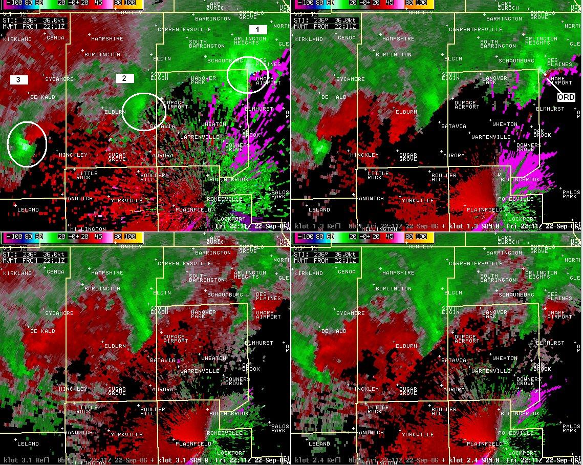 RADAR IMAGES FROM NORTHERN ILLINOIS SHOWING THE ROTATING STORMS ON FRIDAY AFTERNOON
STATE OF EMERGENCY DECLARED
| NewsEmergency.com Local Storms prompt State of Emergency in areas of Kentucky |
|
|
|
ILLINOIS SEVERE THUNDERSTORMS AND TORNADOES - FROM THE NWS IN CHICAGO
Selected Radar Images from September 22, 2006 Severe Weather
Over Northeast Illinois
RADAR IMAGES FROM THE CHICAGO NWS OFFICE
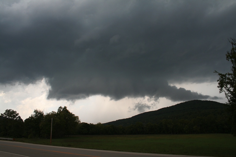
The image above was taken about 5 miles south of Dekalb by Thomas Zerebny.
STRONGEST TORNADO EVER RECORDED DURING THE MONTH OF SEPTEMBER
FOR THE PADUCAH FORECAST AREA

http://www.crh.noaa.gov/crnews/display_story.php?wfo=pah&storyid=3793&source=0
Damage surveys revealed the long-track tornado across Perry County, Missouri into Jackson County, Illinois on Sept. 22 reached F-4 intensity. Preliminary data indicates the tornado was a low-end F-4 with peak winds of 210 MPH in Perry County. The F-4 classification ranges from 207 to 260 MPH. The tornado damage in the Jackson County portion of the path was rated F-2.
Click on map below for larger version of preliminary tornado path map. Additional tornado paths will likely be plotted. Tornado damage was recently confirmed by a survey in Crittenden and Webster Counties of Kentucky. Other possible tornado damage is in eastern Ballard County near Oscar and in Pope County, IL.
TRACK THROUGH JACKSON COUNTY ILLINOIS
THE JACKSON COUNTY TORNADO WARNING
WFUS53 KPAH 222059
TORPAH
ILC077-199-222200-
/O.NEW.KPAH.TO.W.0089.060922T2059Z-060922T2200Z/

BULLETIN - EAS ACTIVATION REQUESTED
TORNADO WARNING
NATIONAL WEATHER SERVICE PADUCAH KY
359 PM CDT FRI SEP 22 2006

THE NATIONAL WEATHER SERVICE IN PADUCAH KENTUCKY HAS ISSUED A

* TORNADO WARNING FOR...
  JACKSON COUNTY IN SOUTHERN ILLINOIS.
  WILLIAMSON COUNTY IN SOUTHERN ILLINOIS.

* UNTIL 500 PM CDT.

* AT 355 PM CDT...WEATHER SERVICE DOPPLER RADAR DETECTED A SEVERE
  THUNDERSTORM WITH STRONG ROTATION 6 MILES SOUTHEAST OF GRAND
  TOWER...OR ABOUT 13 MILES NORTHWEST OF ANNA....MOVING NORTHEAST AT
  45 MPH.

* THE TORNADO IS EXPECTED TO BE...
  NEAR MAKANDA BY 410 PM CDT.
  NEAR CARBONDALE BY 415 PM CDT.
  NEAR CARTERVILLE...CAMBRIA AND CRAINVILLE BY 425 PM CDT.
  NEAR HERRIN...ENERGY AND COLP BY 430 PM CDT.
  NEAR WHITEASH AND SPILLERTOWN BY 435 PM CDT.

TAKE COVER NOW. MOVE INDOORS...AND TAKE SHELTER IN A BASEMENT OR
SMALL INTERIOR ROOM ON THE LOWEST FLOOR. STAY AWAY FROM WINDOWS.
EVACUATE MOBILE HOMES AND VEHICLES. IF CAUGHT IN THE OPEN...SEEK
SHELTER IN A DITCH OR LOW SPOT.

LAT...LON 3762 8956 3759 8931 3775 8887 3787 8903

$$

RP/MY
-----------------------------
NATIONAL WEATHER SERVICE - LITTLE ROCK INFORMATION
http://www.srh.weather.gov/lzk/html/svr0906a.htm
SEPTEMBER 21 START OF EVENT
A strong storm system headed from the Rockies into the Plains on September 21st. The system dragged a cold front toward Arkansas, with the front pushing through on the 23rd. Ahead of the front, warmth and moisture increased markedly...with several rounds of strong to severe thunderstorms.In the picture: A storm system ("L") was in northern Kansas late on 09/21/2006, with winds aloft (30,000 feet shown) increasing around the system and moisture drawn toward the system from the Gulf of Mexico (dewpoints climbing from the 50s into the 60s/lower 70s).
In the picture: By the evening of 09/22/2006, the system headed toward the Dakotas...with lots of wind energy aloft and copious moisture in place (dewpoints in the 60s/70s). Storms began firing during the evening of the 21st. Dewpoints (a measure of moisture in the air) increased from the 50s into the 60s/lower 70s...especially in western Arkansas. There was also a lot of shear, with a southeast wind at ground level and a strong southwest wind aloft. As the wind turned with height, storms showed signs of rotation.
| In the picture: The satellite showed swirling clouds in southeast Nebraska at 10 pm CDT on 09/21/2006, with the clouds associated with a storm system aloft. South of the system, severe thunderstorms were in western Arkansas.
One storm in particular tracked from Polk County into Montgomery County, with Tornado Warnings issued by the National Weather Service. In the picture: The WSR-88D (Doppler Weather Radar) showed a severe storm just south of Mena (Polk County) at 1030 pm CDT on 09/21/2006.
Trees were downed around Grannis (Polk County) and Welsh (Montgomery County), with tin off of a chicken house at Bogg Springs (Polk County) In the picture: The storm just south of Mena (Polk County) was rotating, with a Tornado Warning issued.
Farther east, storms that popped up during the early morning hours of the 22nd were not as potent...but were still severe. Penny size hail was produced at Haskell (Saline County), with power lines downed at Batesville (Independence County). Later on the 22nd, strong shear was displaced into northern Arkansas and areas farther north (such as Missouri and Illinois) as the system in Kansas headed for the Dakotas. Tornadoes were most likely in these areas, and less of a concern farther southwest.In the picture: A severe (and potentially tornadic) storm was seen in Newton County from Eureka Springs (Carroll County) around 630 pm CDT on 09/22/2006. SEPTEMBER 22-23 EVENT True to form, scattered to numerous thunderstorms erupted near the Arkansas/Missouri border...with strong rotation in many of the storms.
In the picture: The satellite showed storms erupting in northern Arkansas during the afternoon of 09/22/2006. In fact, 31 Tornado Warnings were issued for 10 counties in the Little Rock County Warning Area from 137 pm CDT to 1045 pm CDT on the 22nd.
Severe weather reports from the SPC
At least two tornadoes have been confirmed in eastern Izard and western Sharp Counties. Funnel clouds were spotted near Mountain Home (Baxter County), just north of Harrison (Boone County) and near Sidney (Sharp County).
There was also very large hail, with baseball size hail or larger just south of Franklin (Izard County), near Brockwell (Izard County) and Ash Flat (Sharp County).
In the pictures: Twenty four hour rainfall as of 7 am CDT
on 09/23/2006.
Thunderstorms continued forming over the same areas into the early morning hours of the 23rd. This led to excessive rainfall in some spots, with amounts over 6 inches reported. Hardy (Sharp County) received 8.20 inches of rain (twenty four hour amount as of 7 am CDT on the 23rd), with 6.75 inches at Corning (Clay County) and 5.10 inches at Salem (Fulton County).
Flash flooding occurred, with water rescues near Hardy (Sharp County). Some people in this area were in trees to avoid the high water. One person reportedly drowned. At Salem (Fulton County), water covered most of the main roads around town...with major flooding at area campgrounds. A creek also overflowed near Williford (Sharp County), with water over U.S. Highway 63.
Water will make its way into area rivers, with flooding along portions of the Black, Cache, Spring and White Rivers.
Severe weather/heavy rain continued into the afternoon of the 23rd, with a front advancing across the state. The wind did not turn so much with height, with less shear overall (i.e. not as much concern for tornadoes). Even so, strong winds aloft over Arkansas created a fast storm movement...with spotty wind damage mainly in the southern and eastern counties.
In the picture: Widespread showers and thunderstorms pushed to the east across Arkansas with a front on 09/23/2006.
Damage Survey Information

A weak (F1) tornado was spawned from near Franklin to near Myron (both in Izard County). Another weak (F1) tornado was mostly in Sharp County, with
damage to at least a dozen homes about 5 miles south of Ash Flat (Sharp County). The tornadoes occurred on September 22nd.


Arkansas damage
DAMAGE PHOTOS FROM THOSE COUNTIES IN ARKANSAS

http://www.srh.weather.gov/lzk/html/svr0906a2.htm
FROM THE LITTLE ROCK NATIONAL WEATHER SERVICE
In the picture: A weak (F1) tornado overturned a recreational vehicle about 5
miles south-southwest of Ash Flat (Sharp County) on 09/22/2006.


In the picture: In the same area, a pole barn was destroyed.


In the picture: About a half mile to the southwest, a mobile home was demolished.


In the picture: The tornado heavily damaged a barn roughly 5 miles south
of Ash Flat (Sharp County).


FLASH FLOODING ALSO HIT ARKANSAS


In the picture: The Spring River at Imboden (Lawrence County) was out of its banks and
up to the level of this house as noted by the debris at the top of the stairs and under the railing.
-------------------------
David Schuttler - storm chaser photos
Tornado warning celled east of Harrison Arkansas.
Brian Emfinger - storm chaser took this photo of a tornadic supercell near St Paul, Oklahoma
Cloud 9 Tour photos from Arkansas...
More chaser photos
http://www.sky-chaser.com/mwcl06c.htm
Chris Collura Photographs - Storm Chaser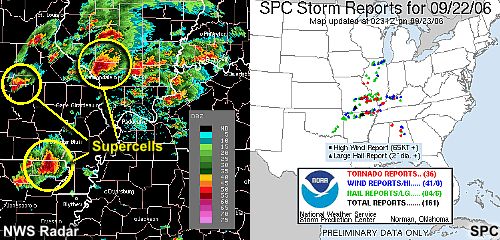
Near Rolla, Missouri
Missouri Severe Thunderstorms - September 22nd
Hillsboro, Missouri - Tornadic Supercell


Wall Cloud near Hillsboro, Missouri - Tornadic Supercell
Also Tornadoes hit on September 21st - the day before the big outbreak
Chaser Photographs
http://www.stormgasm.com/9-21-06/9-21-06.htm
Simon Brewer documented a tornado outbreak in North-Central Kansas. Simon documented one tornado,
which passed through the west-side of Russell, KS causing damage in the town.
Simon Brewer documented a tornado outbreak in North-Central Kansas. Simon documented one tornado,
which passed through the west-side of Russell, KS causing damage in the town.


Simon Brewer documented a tornado outbreak in North-Central Kansas. Simon documented one tornado,
which passed through the west-side of Russell, KS causing damage in the town.
MORE ON THE TORNADO OUTBREAK CLICK HERE
HOME PAGE
------------------------------------------------------

------------------------------------------------------

LIVE: VIEW
FROM DOWNTOWN PADUCAH

...VIA WEB CAM FROM WPSD NEWS CHANNEL  6

------------------------------------------------------
------------------------------------------------------
MAILING ADDRESS
BEAU DODSON
465 Ashcreek Road
Paducah, Kentucky
42001
-
Phone Number
Home 270-554-6715
Cell 270-970-1202
Email beaudodson@hotmail.com