July 4, 2005
HAPPY FOURTH OF JULY EVERYONE!
Great fourth of July down here in
Florida. We are all watching the tropical depressions (yes that is two
now) in the Gulf of Mexico. Could be an interesting few days ahead of us
down here!
TON of fireworks on the beach
tonight. I had a blast watching the show with Kristy and everyone
else. There were hundreds of fireworks up and down the beach. It
seemed like everyone and their brother were setting them off! It was fun.
Mother Nature gave us a beautiful show as
well. An incredible sunset and an amazing RAINBOW! All at the same
time! A sunset rainbow!
Here are a few photographs from this
afternoon and evening :)

Kristy and Beau on Destin Beach

Kristy and friends :)

The Peanuts Gang on the beach

Lucy strutting her stuff

Beau...Kristy...Joey
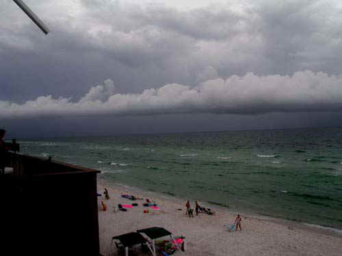
Tropical Depression Three Moving In...

An AMAZING SUNSET
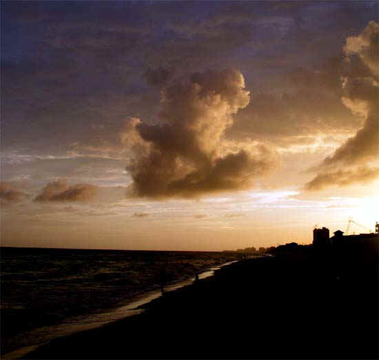
Sunset Photos...

Destin Beach...Sunset - July 4th

And the rainbow behind us :)


Destin at Sunset :)

Bright RAINBOW!!!!

Sunset Rainbow in Destin

Destin about to lose their sun...

Beau and Kristy
TROPICAL WEATHER
TROPICAL DEPRESSION THREE AND FOUR ARE
MOVING INTO THE GULF OF MEXICO. TROPICAL STORM WATCHES HAVE BEEN
ISSUED TO THE WEST OF THIS AREA. IT APPEARS THAT WE SHOULD GET SOME HEAVY
RAIN AND HIGH WINDS OVER THE NEXT TWO DAYS.
UPDATED EVENING FORECAST MAP FOR THE
TRACK OF THIS SYSTEM
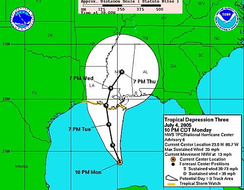
FORECAST TRACK FOR TROPICAL DEPRESSION 3
DEPRESSION FOUR HAS ALSO NOW FORMED -
ACTIVE SEASON ALREADY
FORECAST TRACK FOR DEPRESSION NUMBER FOUR HAS NOW
BEEN ISSUED AS WELL
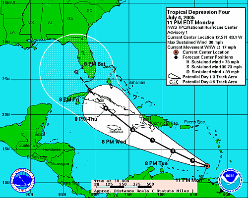
TROPICAL DEPRESSION NUMBER FOUR - FORECAST TRACK
TUESDAY MORNING...
TROPICAL STORM WATCH NOW FOR DESTIN, FLORIDA.
TROPICAL STORM WARNINGS TO OUR WEST. RAINING HERE THIS MORNING ALREADY.
BULLETIN TROPICAL STORM CINDY INTERMEDIATE ADVISORY
NUMBER 7A
NWS TPC/NATIONAL HURRICANE CENTER
MIAMI FL 7 AM CDT TUE JUL 05 2005 ...
CINDY HEADING NORTHWARD TOWARD THE NORTH-CENTRAL GULF
COAST...
A TROPICAL STORM WARNING IS IN EFFECT FOR THE NORTHERN
GULF COAST FROM INTRACOASTAL CITY LOUISIANA TO PASCAGOULA MISSISSIPPI INCLUDING
THE CITY OF NEW ORLEANS AND LAKE PONTCHARTRAIN... AND A TROPICAL STORM WATCH IS
IN EFFECT FROM EAST OF PASCAGOULA TO DESTIN FLORIDA.
A TROPICAL STORM WARNING MEANS THAT TROPICAL STORM
CONDITIONS ARE EXPECTED WITHIN THE WARNING AREA WITHIN THE NEXT 24 HOURS. FOR
STORM INFORMATION SPECIFIC TO YOUR AREA...INCLUDING POSSIBLE INLAND WATCHES AND
WARNINGS...PLEASE MONITOR PRODUCTS ISSUED BY YOUR LOCAL WEATHER OFFICE.
T 7 AM CDT...1200Z...THE CENTER OF TROPICAL STORM CINDY
WAS LOCATED NEAR LATITUDE 26.4 NORTH...LONGITUDE 90.4 WEST OR ABOUT 200 MILES
SOUTH-SOUTHWEST OF THE MOUTH OF THE MISSISSIPPI RIVER. CINDY IS MOVING TOWARD
THE NORTH NEAR 14 MPH...AND THIS GENERAL MOTION IS EXPECTED TO CONTINUE FOR THE
NEXT 24 HOURS. THIS TRACK WOULD BRING CINDY NEAR THE LOUISIANA COAST LATE NIGHT
OR EARLY ON WEDNESDAY.
MAXIMUM SUSTAINED WINDS HAVE INCREASED TO NEAR 45
MPH...WITH HIGHER GUSTS IN SQUALLS...TO THE EAST OF THE CENTER. SOME ADDITIONAL
STRENGTHENING IS POSSIBLE BEFORE LANDFALL. TROPICAL STORM FORCE WINDS EXTEND
OUTWARD UP TO 85 MILES TO THE NORTH AND EAST OF THE CENTER. LATEST MINIMUM
CENTRAL PRESSURE JUST REPORTED BY AN AIR FORCE RECONNAISSANCE PLANE WAS 1002
MB...29.59 INCHES.
STORM SURGE FLOODING OF 4 TO 7 FEET ABOVE NORMAL TIDE
LEVELS IS POSSIBLE NEAR AND TO THE EAST OF WHERE THE CENTER CROSSES THE COAST.
TOTAL RAINFALL ACCUMULATIONS OF 4 TO 6 INCHES ARE POSSIBLE OVER THE CENTRAL GULF
COAST..WITH ISOLATED MAXIMUM AMOUNTS TO 10 INCHES.
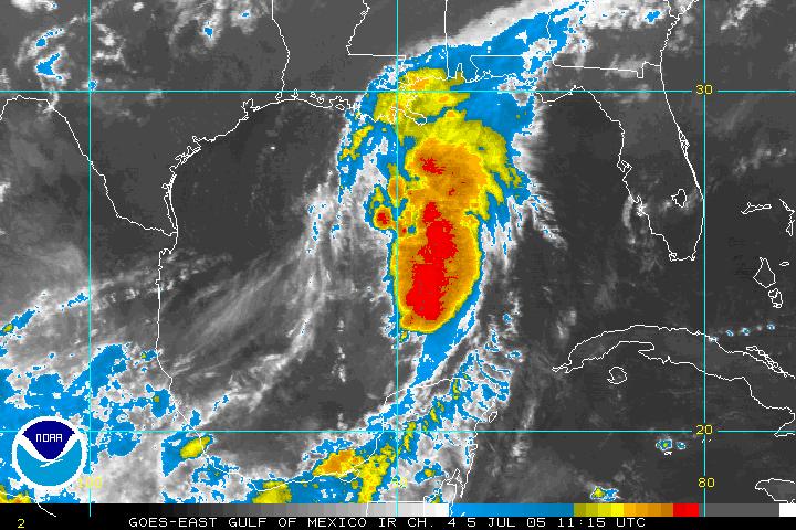
CINDY HAS FORMED IN THE GULF OF MEXICO
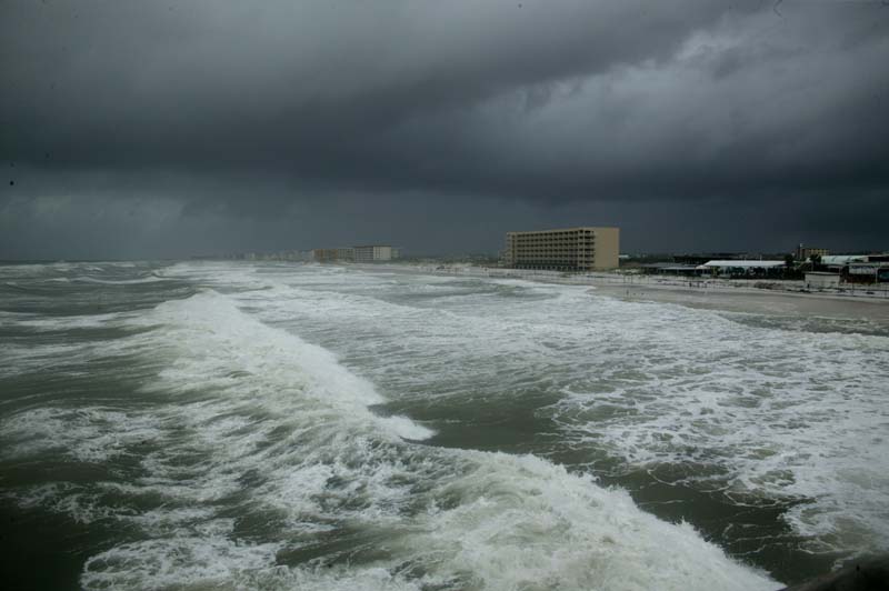
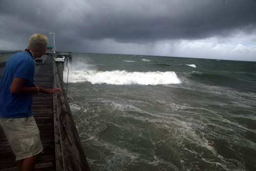
THE SURF IS ROUGH DOWN BELOW THIS MORNING
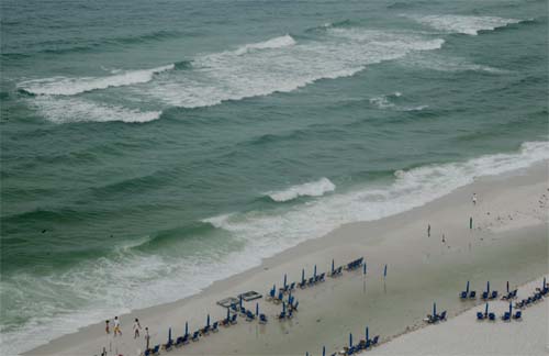
Waves are pounding the shoreline.
NOW DENNIS
HAS FORMED IN THE CARIBBEAN. THIS IS A RECORD NUMBER OF STORMS TO FORM SO
EARLY.
WTNT34 KNHC 051439
TCPAT4
BULLETIN
TROPICAL STORM DENNIS ADVISORY NUMBER 3
NWS TPC/NATIONAL HURRICANE CENTER MIAMI FL
11 AM EDT TUE JUL 05 2005
...CARIBBEAN DEPRESSION BECOMES TROPICAL STORM DENNIS...
AT 11 AM EDT...1500Z...THE GOVERNMENT OF THE DOMINICAN REPUBLIC HAS
ISSUED A TROPICAL STORM WATCH FOR THE SOUTH COAST
OF THE DOMINICAN
REPUBLIC FROM BARAHONA WESTWARD AND THE GOVERNMENT OF HAITI HAS
ISSUED A TROPICAL STORM WATCH FOR THE SOUTHWEST PENINSULA OF HAITI
FROM THE DOMINICAN REPUBLIC BORDER AND PORT-AU-PRINCE WESTWARD.
INTERESTS IN THE CENTRAL AND WESTERN CARIBBEAN SEA SHOULD MONITOR
THE PROGRESS OF THIS SYSTEM.
FOR STORM INFORMATION SPECIFIC TO YOUR AREA...INCLUDING POSSIBLE
INLAND WATCHES AND WARNINGS...PLEASE MONITOR PRODUCTS ISSUED
BY YOUR LOCAL WEATHER OFFICE.
SATELLITE IMAGES INDICATE THAT TROPICAL DEPRESSION FOUR HAS
STRENGTHENED INTO A TROPICAL STORM. JULY 5 IS THE EARLIEST DATE ON
RECORD FOR 4 NAMED STORMS TO HAVE FORMED IN THE ATLANTIC BASIN.
AT 11 AM EDT...1500Z...THE CENTER OF TROPICAL STORM DENNIS WAS
LOCATED NEAR LATITUDE 13.3 NORTH... LONGITUDE 66.6 WEST OR ABOUT
355 MILES... 570 KM... SOUTH OF SAN JUAN PUERTO RICO.
DENNIS IS MOVING TOWARD THE WEST-NORTHWEST NEAR 18 MPH ...30
KM/HR...AND THIS GENERAL MOTION IS EXPECTED TO CONTINUE FOR THE
NEXT 24 HOURS.
MAXIMUM SUSTAINED WINDS ARE NEAR 40 MPH... 65 KM/HR...WITH HIGHER
GUSTS. SOME STRENGTHENING IS FORECAST DURING THE NEXT 24 HOURS.
--------------------------
TROPICAL STORM WARNING NOW FOR DESTIN,
FLORIDA. CINDY IS GETTING STRONGER. WINDS ARE UP TO 50 MILES PER
HOUR NEAR THE CENTER.
CINDY NEARING HURRICANE STRENGTH TONIGHT...WINDS ARE
70 MILES PER HOUR. GUSTS HAVE BEEN REPORTED AS HIGH AS 100 MILES PER HOUR
ON ONE OF THE OFF-SHORE OIL RIGS.
VERY HIGH SURF HERE IN DESTIN. WAVES ARE PROB
AROUND 10 FEET HIGH ON THE SAND BAR IN FRONT OF THE CONDO. THE ROAR OF THE
SURF SOUNDS LIKE JET ENGINES. IT IS A SOUND I HAVE NEVER HEARD FROM THE
OCEAN.
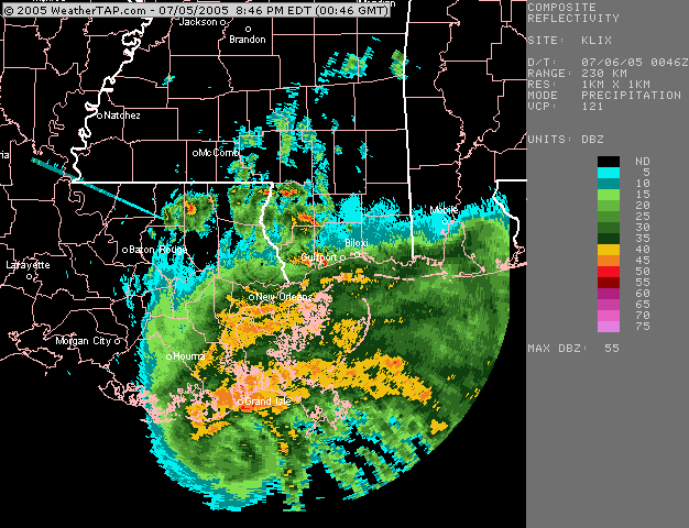
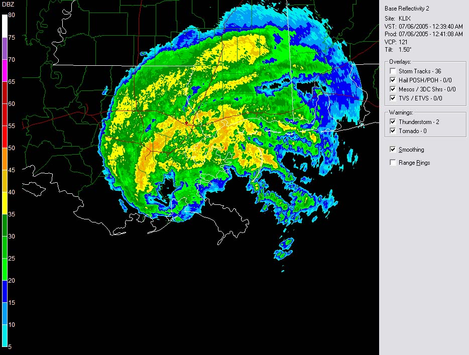
8:30 p.m. NATIONAL WEATHER SERVICE RADAR - THERE SHE
SPINS JUST SOUTH OF
LOUISIANA COASTLINE.
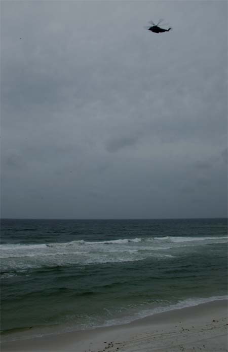
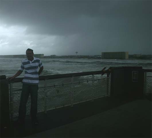
Helicopter patrolling the shoreline

We made this sign to Welcome her ashore :)

Beau and Joey Welcome Cindy to the Gulf of Mexico :)

Destin, Florida
So the tropical storm is moving ashore
tonight. Another storm is popping in the Caribbean. Dennis.
Dennia could become a strong hurricane. That one will have to be
watched. Dennis won't hit until later in the weekend.
WTNT63 KNHC
060345 TCUAT3
TROPICAL STORM CINDY
TROPICAL CYCLONE UPDATE
NWS TPC/NATIONAL HURRICANE CENTER MIAMI FL 1045 PM CDT TUE JUL 05 2005
DATA FROM AN AIR FORCE RESERVE HURRICANE HUNTER AIRCRAFT AND DOPPLER RADAR DATA
FROM SLIDELL LOUISIANA INDICATE THAT THE CENTER OF TROPICAL STORM CINDY CROSSED
THE LOUISIANA COAST LINE AROUND 1030 PM CDT...OR 0330 UTC...ABOUT 14 MILES
SOUTHWEST OF GRAND ISLE LOUISIANA. CINDY IS EXPECTED TO CONTINUE MOVING FARTHER
INLAND AND SLOWLY WEAKEN.
FORECASTER STEWART $$
Wednesday
TROPICAL STORM CINDY - MOVING THROUGH
EXTREMELY windy here this morning.
Bands from the tropical storm are moving through Destin. You can hardly
open the door. The winds are gusting very high up here on the 16th floor
of this building. The waves and swells are pouring up on the
beach.
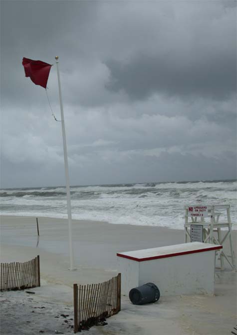
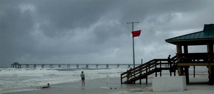
THE BEACH BELOW
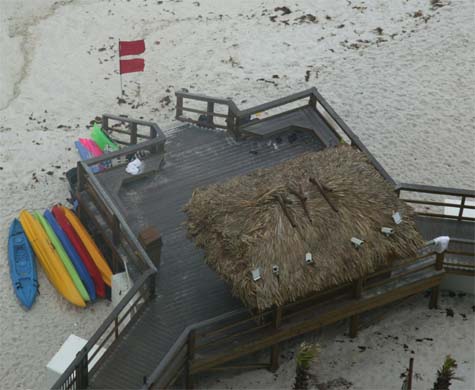
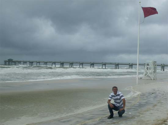
Double Red Flag this morning
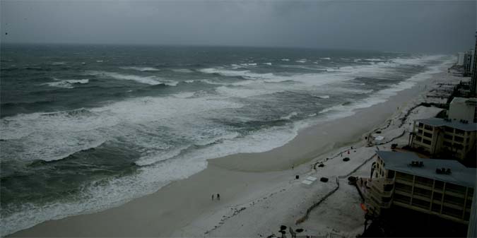
VERY HIGH SURF
Just got back in from Fort Walton Beach. This beach is about 5-8 miles to the west of Destin. The surf there is insane. The wind is sustained at around 30 miles per hour and occasionally there are gusts to around 50 mph. The sea foam is really kewl. The wind is blowing the water way up on the beach as the waves pound the shore.
There were about 50-60 people up and down the beach. Most of them were up on the docks taking pictures. A few people were actually in the rough seas.
About every 10 minutes a small rain band passes overhead. The rain and sand beats on you like small BBs'. The wind grows much stronger when the bands pass overhead. We had to hide underneath a pier from time to time...as the rain got pretty heavy.
I defin won't forget this experience. The sustained winds is prob the most impressive thing about tropical weather. We don't get sustained winds like this back home :) We get high winds from time to time but not the sustained force. Pretty impressive. I can't even imagine what a hurricane would be like. It must be pretty scary.
Here are a few more photographs -
Fort Walton Beach - Cindy
Sea Foam
Fort Walton Beach Pier
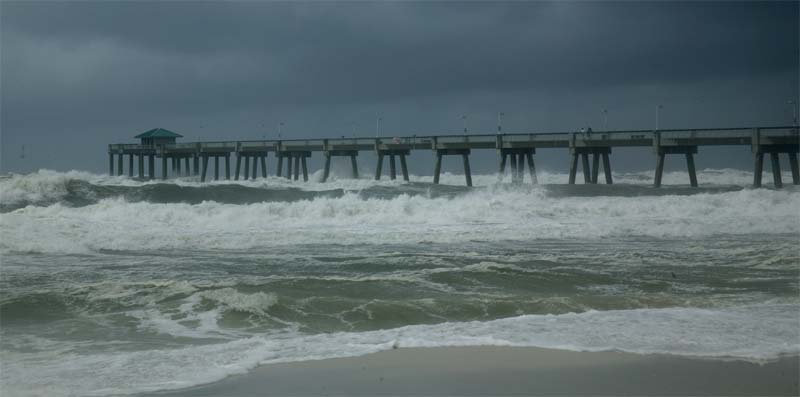
ROUGH SEAS AT FORT WALTON BEACH
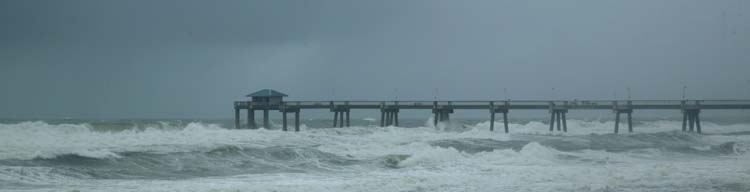
Fort Walton Beach - huge waves
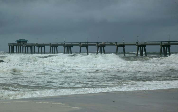
Pier on the beach being beaten by the waves
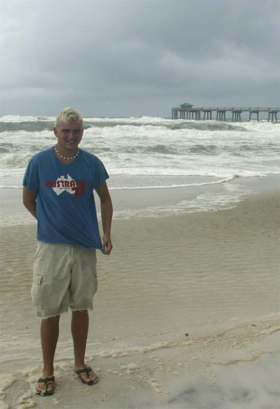
Joey on the beach

Fort Walton Beach Pier
Beau on Fort Walton beach :)
Looking towards the city from the Pier
Joey on the pier
Me blowing around on the pier :) squall is right upon us now
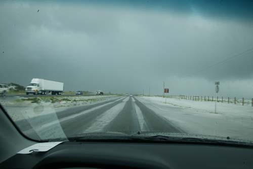
Sand blowing across the road to Destin
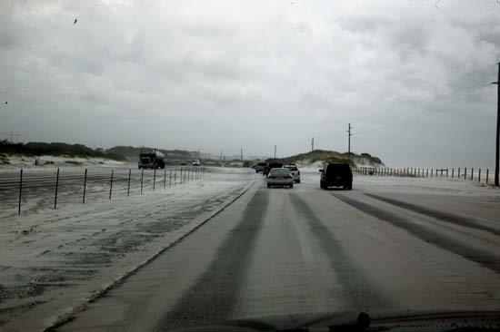
Sand drifting across the road to Destin - SNOWSTORM!
DESTIN WINTER STORM :)
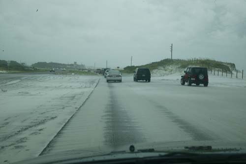
Sand blowing
WEDNESDAY EVENING
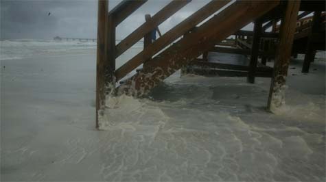
CINDY DAMAGE PICTURES FROM THE BEACH HERE IN DESTIN

Below the condo...everything is being torn apart
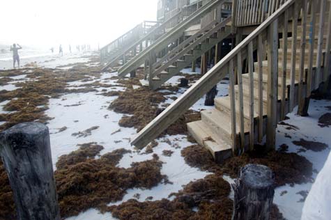
Stairs are torn apart in front of the condo
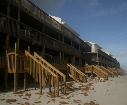
Damage at the condos
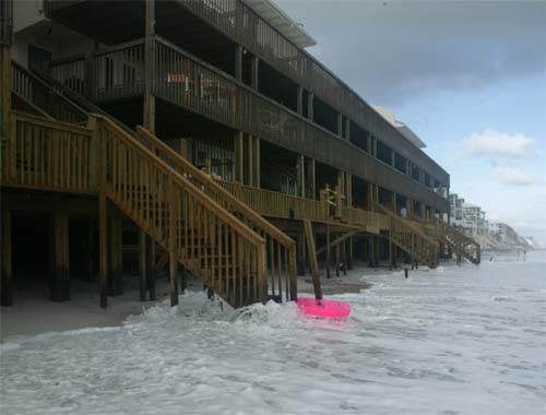
Water splashing up to the condos. Normally the water would
be way below this area.
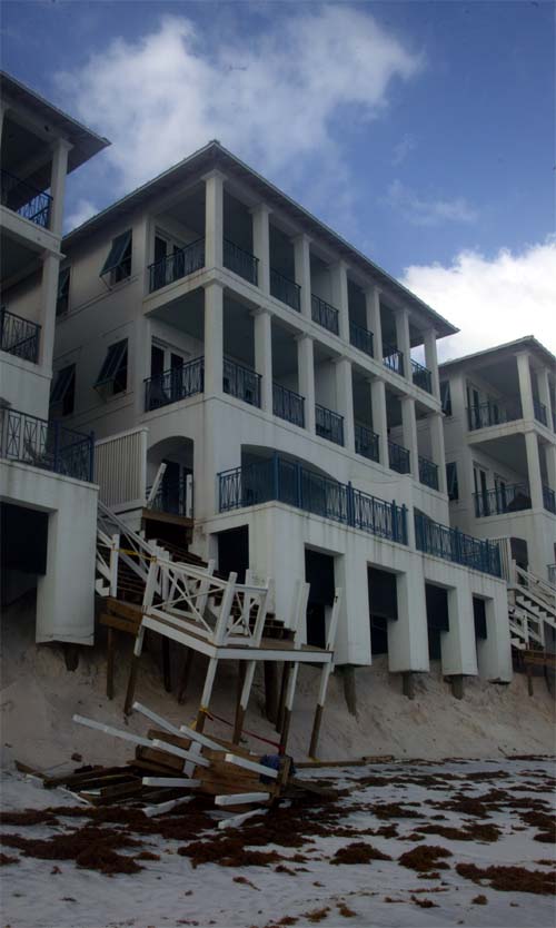
Damage down on the beach
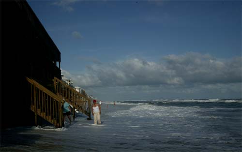
Waves pounding still during the late afternoon hours
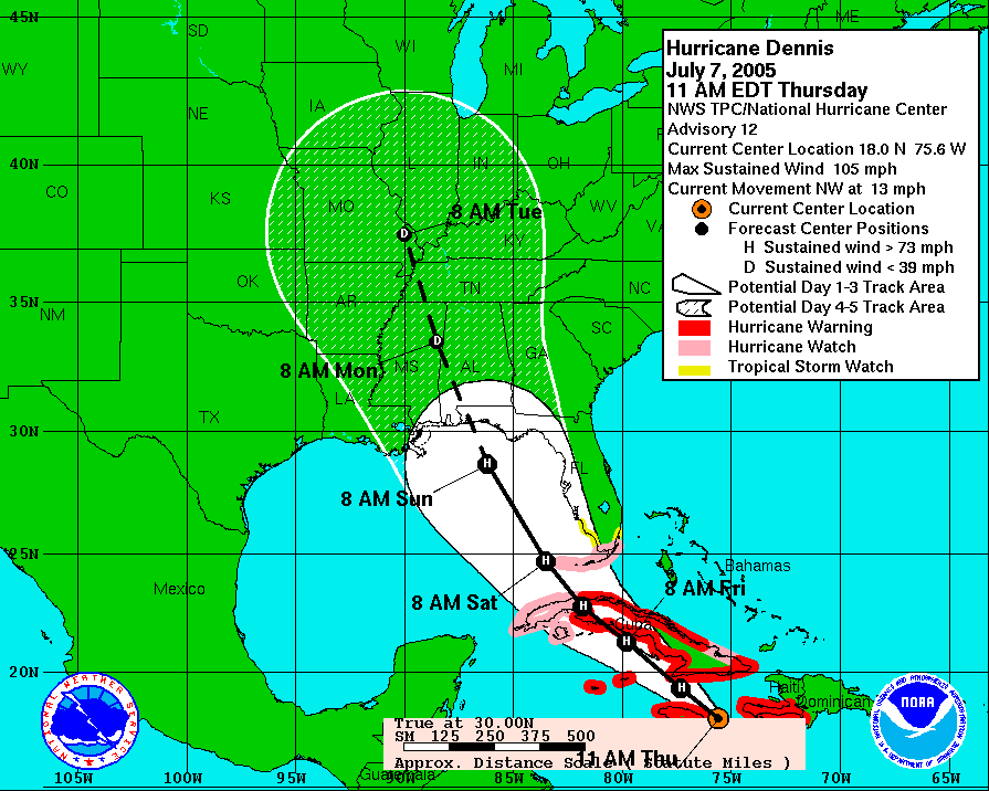
HURRICANE DENNIS
HURRICANE DENNIS IS GAINING STRENGTH IN
THE CARIBBEAN. DENNIS COULD BECOME A CATEGORY THREE HURRICANE BY EARLY
THIS WEEKEND. RIGHT NOW IT APPEARS THAT IT WILL HIT SOMEWHERE ALONG THE
NORTHERN GULF COAST.
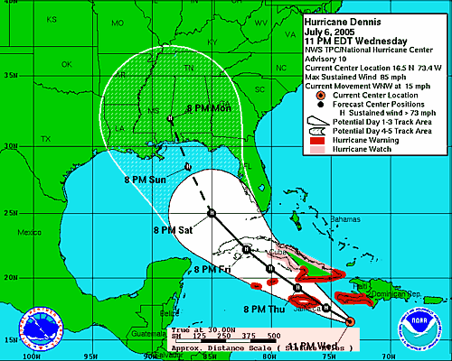
WEDNESDAY - DENNIS FORECAST TRACK FOR THIS WEEKEND
THURSDAY - 7/7/05
CITY OF LONDON UNDER ATTACK THIS MORNING
TERRORISTS' ATTACKING LONDON
DOZENS DEAD FROM AN ORGANIZED ATTACK ON
THE TRANSIT SYSTEM.
1000+ INJURED IN THE ATTACKS
AL QUAIDA HAS CLAIMED RESPONSIBILITY FOR
THE ATTACK.
Scotland Yard Says...
Edgeware Road, Kings Cross, Liverpool
Street, Russell Square, Aldergate East, and Moorgate. Plus the bus, toen apart.
Four to Seven explosions in all.
Bomb attacks in the subway system and
bus systems.
-----------
HURRICANE DENNIS BECOMES A DANGEROUS SYSTEM
WINDS ARE NOW AT 105 MILES PER HOUR.
THE SYSTEM IS MOVING THROUGH THE CARIBBEAN AT THIS TIME. IT APPEARS THAT
FLORIDA TO LOUISIANA COULD BE HIT HEAD ON BY DENNIS. DENNIS IS EXPECTED TO
MAINTAIN ITS STRENGTH AS HE MOVES NORTH/NORTHWEST.
BULLETIN HURRICANE DENNIS INTERMEDIATE
ADVISORY NUMBER 11A
NWS TPC/NATIONAL HURRICANE CENTER MIAMI FL
8 AM EDT THU JUL 07 2005 ...
DENNIS STRENGTHENS TO 105 MPH...
AT 8 AM EDT...1200Z
THE CENTER OF HURRICANE DENNIS WAS LOCATED NEAR LATITUDE 17.5 NORTH...LONGITUDE
74.9 WEST OR ABOUT 130 MILES...205 KM...EAST-SOUTHEAST OF KINGSTON JAMAICA AND
ABOUT 165 MILES... 265 KM...SOUTH OF GUANTANAMO CUBA.
DENNIS WOBBLED TOWARD THE NORTHWEST AROUND 10 MPH...16 KM/HR...OVER THE PAST FEW
HOURS...BUT A GENERALLY WEST-NORTHWESTWARD MOTION NEAR 13 MPH...20 KM/HR...IS
EXPECTED DURING THE NEXT 24 HOURS. ON THIS TRACK...DENNIS IS EXPECTED TO BE OVER
OR VERY NEAR JAMAICA LATER TODAY.
REPORTS FROM AN AIR FORCE HURRICANE HUNTER PLANE INDICATE THAT THE MAXIMUM
SUSTAINED WINDS HAVE INCREASED TO NEAR 105 MPH...165 KM/HR...WITH HIGHER
GUSTS.
DENNIS IS NOW A CATEGORY TWO HURRICANE ON THE SAFFIR-SIMPSON SCALE. ADDITIONAL
STRENGTHENING IS FORECAST DURING THE NEXT 24 HOURS.
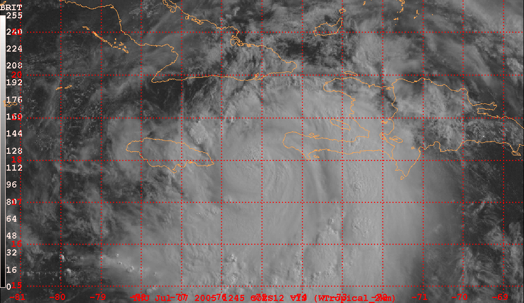
MORNING SATELLITE GRAB FROM RaleighWx.
DENNIS CHURNS THROUGH THE CARIBBEAN.
UPDATED FORECAST TRACK - THURSDAY MORNING
LONDON ATTACKS...NEWS WIRE
"Barbaric
attacks"
A coordinated series of suspected
terrorist hits on London's transportation system sends capital into chaos.
-
- - - - - - - - - - -
By Sarah Left and Mark Oliver
July
7, 2005 | LONDON
--
A series of explosions ripped through
London's transport system today as suspected terrorist attacks on tube trains
and a bus plunged the capital into chaos. At least two people are known to have
been killed, and hundreds of wounded are being treated in London hospitals.
[Update: A U.S. official put the death toll at about 40.]
Officials shut down the whole of the London
Underground system and the Docklands Light Railway, and also cancelled all
central London bus services as they tried to comprehend the scale of the
disaster. The prime minister, Tony Blair, said it was "reasonably
clear" that the blasts were the work of terrorists, and added that it was
"particularly barbaric" that attacks had been timed to coincide with
the start of the G8 summit. He said he would leave Gleneagles, in Scotland, to
return to London.
With the leaders of the G8 nations lined up
behind him, Blair said: "We condemn utterly these barbaric attacks.
11 a.m.
DENNIS MOVING TOWARDS JAMAICA - CHECK OUT
THE EYE
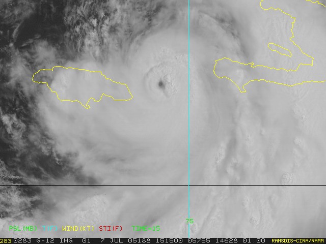
THURSDAY MORNING LATE...
Looks like this hurricane is gaining
strength. I would imagine it is even stronger now than 105 miles per
hour. I believe we might be helping out friends board up their condo today
or tomorrow. Appears that Dennis might be heading for the Panhandle
area. Still time to watch it though.
HURRICANE DIARY TURN THE
PAGE CLICK HERE
RETURN TO HOME PAGE
See PADUCAH Live View Web-Cam Below
------------------------------------------------------
------------------------------------------------------
LIVE: VIEW
FROM DOWNTOWN PADUCAH
...VIA WEB CAM FROM WPSD NEWS CHANNEL 6

------------------------------------------------------
------------------------------------------------------
MAILING ADDRESS
BEAU DODSON
465 Ashcreek Road
Paducah, Kentucky
42001
Phone Number
Home 270-554-6715
Cell 270-970-1202
Email beaudodson@hotmail.com