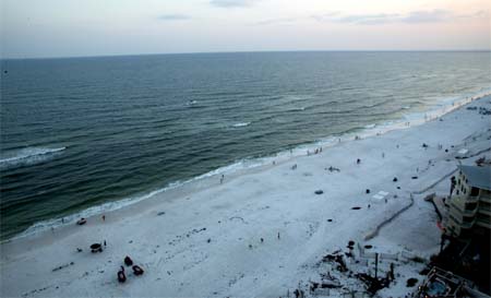
Destin this evening. The calm before the storm. People are out and
about on the beaches below. They are singing down below the hotel
here at an outdoor Karaoke event.
HURRICANE DENNIS DIARY
Staying for Dennis. This will be the first hurricane I have ever been in. I have always wanted to experience one. I guess I will have my chance now.
At 8 p.m. Hurricane Dennis continues to strengthen. The National Hurricane Center is now reporting winds of 130 miles per hour with gusts to 150 miles per hour. Dennis will soon be a category four hurricane. This is on a scale of 1 to 5. Dennis is a very dangerous and large hurricane this evening. He will approach Cuba tonight and tomorrow morning.
There are no current evacuation orders for the Destin area. Hurricane watches have been issued for the Florida Keys.
The surf here in Destin is pretty calm. It was rough yesterday because of Tropical Storm Cindy. Much better today though. There are long lines at the gas stations and the grocery stores are a nightmare. People are stocking up on everything. Local people are worried. Tourists are paying attention to The Weather Channel. Most people are just enjoying their day and trying not to worry too much about what is coming. There is still hope among the local people that this storm won't make a direct hit. This area has still NOT recoverd totally from Ivan.
People here at the condo-resort are pretty calm. Right now people are out walking along the beach and enjoying the warm evening air. The sunset is a beautiful orange and red. There are a few scattered cumulus clouds to the south and southwest. Nothing major though. There are lots of people down below at the Karaoke Bar singing and dancing. Everyone is having a good time. :)
Destin this evening. The calm before the
storm. People are out and
about on the beaches below. They are singing down below the hotel
here at an outdoor Karaoke event.
The current plan is to stay here as long as possible. I am fairly certain they will eventually make us leave with mandatory evacuations of this "island" area. If that happens then we will likely go to Pensacola to ride the hurricane out.
We have bought bottled water, battery radio, flashlights, and food. Other emergency supplies as well. My biggest concern is when they have a mandatory evacuation is where we will go. Checking on hotels in Pensacola for Sunday and Monday.
Noted thetrump is a local down here at the air force base and is posting on Wright-Weather. Will be watch for his reports as well. He is not far from where I am staying.
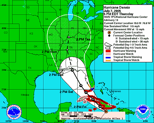
The
National Hurricane Center is tracking this storm into the Florida Panhandle on
Sunday. They are forecasting it to be a powerful hurricane at that
time. The local National Weather Service in Mobile, Alabama says the
following:
THERE IS A POTENTIAL FOR SEEING DENNIS MAKE LANDFALL AS A CATEGORY 3
HURRICANE ALONG THE CENTRAL GULF COAST ON SUNDAY. CONDITIONS COULD BE SIMILAR TO
HURRICANE IVAN.
LATEST 4 PM NHC TRACK TAKES THE CENTER OF DENNIS TO NEAR DESTIN FLORIDA AROUND
MIDDAY SUNDAY.
THE GLOBAL MODEL CONSENSUS HAS DEFINITELY SEEN A SHIFT EASTWARD WITH THE TRACK
TO AROUND THE APALACHICOLA AREA. NHC TRACKS HAVE ALSO SHIFTED SLIGHTLY MORE
EASTWARD SINCE YESTERDAY. WE WOULD CAUTION FOLKS TO NOT GET TOO HUNG UP ON THE
CENTER OF THE FORECAST CONE...AS ERROR DOES PLAY A ROLE IN THE 72-120 HR
FORECAST TRACKS. THE FAVORED MODELS (GFDL/GFS) HAVE TRENDED FURTHER EAST OVER
THE PAST 24 HOURS DUE TO WEAKENING THE WESTERN EXTENT OF THE SUBTROPICAL
ATLANTIC RIDGE AXIS. SHOULD THIS RIDGE PLAY OUT TO BE A LITTLE STRONGER THAN
WHAT WE ARE CURRENTLY SEEING...THE TRACK COULD BE SHIFTED A LITTLE BACK TO THE
WEST AGAIN ON LATER FORECASTS.
RESIDENTS IN COASTAL ALABAMA SHOULD NOT LET THEIR GUARD DOWN YET. THE 4 PM
FORECAST PACKAGE IS BASED ON DENNIS MOVING INLAND OVER THE FLORIDA PANHANDLE
SUNDAY (THIS COULD CHANGE)...THEN INLAND ACROSS SOUTH ALABAMA LATE SUNDAY INTO
EARLY MONDAY. WE ARE TRENDING BACK TO A DIURNAL POP/MORE TYPICAL FORECAST IN THE
LATER PARTS OF THE MEDIUM RANGE PERIODS.
THIS IS THE TRACK FORECAST AT THIS TIME:
HURRICANE FORECAST THIS EVENING
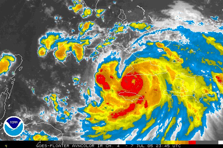
LATEST SATELLITE PHOTO OF DENNIS.
GEMPAK IMAGE FROM RALEIGH-WX- DENNIS THIS EVENING
CURRENT WATCHES AND WARNINGS
Hurricane Warning
in Effect for the lower Florida Keys from the Seven Mile Bridge westward to the
Dry Tortugas...Tropical Storm Warning Issed for the Remainder of the Florida
Keys East of the Seven Mile Bridge to Ocean Reef and Florida Bay...Tropical
Storm Watch in Effect for all of the Southern Florida Peninsula
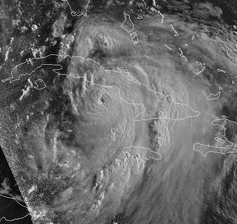
LATE EVENING SATELLITE IMAGE - DENNIS HITTING PORTIONS OF CUBA
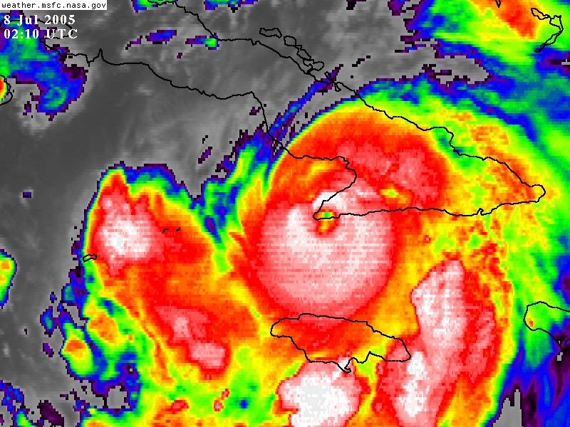
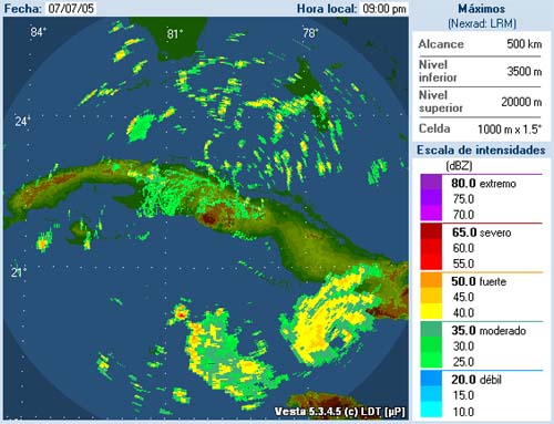
Radar from Cuba this evening shows the eye of the storm
9:00 p.m.
DENNIS IS NOW A CATEGORY FOUR HURRICANE WITH WINDS OF 135 MILES PER HOUR. HE IS NOW HITTING CUBA.
BULLETIN HURRICANE DENNIS
ADVISORY NUMBER 14 NWS TPC/NATIONAL HURRICANE CENTER MIAMI FL
11 PM EDT THU JUL 07 2005
AT 11 PM EDT...0300Z...THE CENTER OF
HURRICANE DENNIS WAS LOCATED NEAR LATITUDE 19.9 NORTH...LONGITUDE 77.6 WEST OR
NEAR CABO CRUZ CUBA AND ABOUT 105 MILES... 170 KM...SOUTH OF CAMAGUEY
CUBA.
DENNIS IS MOVING TOWARD THE NORTHWEST NEAR 15 MPH ...24 KM/HR...AND THIS GENERAL
MOTION IS EXPECTED TO CONTINUE FOR THE NEXT 24 HOURS. THIS MOTION SHOULD BRING
THE CENTER OF DENNIS NEAR OR OVER SOUTHEASTERN CUBA TONIGHT AND CENTRAL CUBA ON
FRIDAY.
MAXIMUM SUSTAINED WINDS ARE NEAR 135 MPH...215 KM/HR...WITH HIGHER GUSTS. DENNIS
IS A CATEGORY FOUR HURRICANE ON THE SAFFIR-SIMPSON SCALE. SOME ADDITIONAL
STRENGTHENING IS POSSIBLE WHILE THE CENTER OF DENNIS REMAINS OVER WATER.
HURRICANE FORCE WINDS EXTEND OUTWARD UP TO 50 MILES... 85 KM... FROM THE
CENTER...AND TROPICAL STORM FORCE WINDS EXTEND OUTWARD UP TO 140 MILES...220
KM.
AMATEUR RADIO REPORTS FROM THE AFFECTED AREA INDICATE WIDESPREAD POWER OUTAGES
AND STRUCTURAL DAMAGE.
ESTIMATED MINIMUM CENTRAL PRESSURE IS 950 MB...28.05 INCHES.
Friday, July 8, 2005
HURRICANE DENNIS CHURNS JUST SOUTH
OF CUBA...
News media says this will be the
strongest hurricane to ever hit Cuba during the month of July.
Pressure down to 935 millibars and winds are now up to at least 140 miles per hour SUSTAINED. Gusts would be nearing 180-190 miles per hour. This is nearing CATEGORY FIVE STRENGTH.
There are a few clouds here in Destin this morning. Plenty of sun
though. It is pretty hazy as well. Warm outside...about like most
days down here. The ocean is calm this morning. The local
forecasters are all watching Dennis now. The hurricane remains a category
four this morning and is tearing up Cuba. Winds are gusting over 160 miles
per hour and seas are in excess of 20 feet. Dennis is a monster
hurricane. There has NEVER in recorded history been a hurricane this
strong so early in the season across this portion of the Atlantic Ocean.
Dennis is breaking some records.
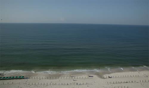
Photo this morning...CALM
There is a little debate as to where Dennis is going to move. Some forecasters are saying Louisiana while other forecasters are saying the Florida Panhandle. The National Hurricane Center is saying Florida is the best bet. It appears that the Panhandle is the target. This could change and hurricanes rarely do what you think they are going to. The Weather Channel has Jim Cantore in Pensacola. This is just a little bit west of Destin.
Right now we are just watching and waiting.
Heading out snorkeling later this morning. Better take advantage of the
good weather while it lasts. The official forecast is for tropical storm
force winds to move into Destin on Saturday and hurricane force winds by Sunday.
Mobile, Alabama, National Weather Service says the following
BASED ON THE LATEST OFFICIAL FORECAST
TRACK...TROPICAL STORM FORCE WINDS...IN ADVANCE OF DENNIS...COULD BEGIN
AFFECTING THE OFFSHORE GULF WATERS AS SOON AS SATURDAY AFTERNOON. THE BEACHES OF
SOUTHWEST ALABAMA AND NORTHWEST FLORIDA COULD SEE TROPICAL STORM FORCE WINDS
MOVING ONSHORE AS EARLY AS 4 AM SUNDAY. HURRICANE CONDITIONS ARE POSSIBLE OVER
THE OUTLOOK AREA ON SUNDAY. HEAVY RAINFALL WILL LIKELY ACCOMPANY HURRICANE
DENNIS...AND RESULT IN EXCEPTIONAL RUNOFF AS THE GROUND REMAINS NEARLY SATURATED
FROM TROPICAL STORM CINDY.
IF THE FORECAST TRACK REMAINS CONSISTENT...EVACUATIONS MAY BE NEEDED BY EARLY
THIS WEEKEND. PRELIMINARY PREPARATIONS SHOULD BE UNDERWAY AT THIS TIME...AND
EMERGENCY ACTION PLANS SHOULD BE INITIATED.
ALSO
DANGEROUS HURRICANE DENNIS (CATEGORY FOUR) JUST OFF
THE SOUTHERN COAST OF CUBA. OUR ENTIRE AREA REMAINS WITHIN THE CONE OF
UNCERTAINTY WITH REGARD TO THE PROJECTED PATH OF THIS DANGEROUS HURRICANE...WITH
THE 4 AM CDT NHC FORECAST TRACK SHIFTED SLIGHTLY WESTWARD. THIS TAKES THE CENTER
OF DENNIS BACK TO NEAR PENSACOLA... BUT STILL MAKING LANDFALL AROUND 7 PM
SUNDAY. WE WOULD CONTINUE TO CAUTION FOLKS TO NOT FOCUS ON THE ACTUAL PROJECTED
PATH...BUT RATHER ON THE FORECAST CONE DUE TO THE UNCERTAINTY. PEOPLE ALONG THE
ENTIRE ALABAMA AND WESTERN FLORIDA PANHANDLE COASTLINE SHOULD BE MAKING THE
EARLY PREPARATIONS FOR THE POTENTIAL OF A MAJOR HURRICANE LANDFALL SOMEWHERE IN
THE REGION BY LATE SUNDAY. THIS TRACK REMAINS CLOSE TO SEVERAL MODEL FORECAST
TRACKS. STRANGELY ENOUGH...THE NAM MODEL AT 06Z IS NOW FURTHER WEST COMPARED TO
THE GFS.
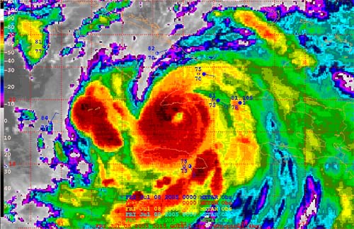
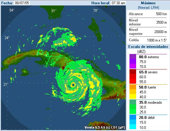
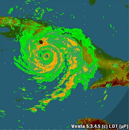
Morning Radar from Cuba
DENNIS CHURNS
ACROSS THE CARIBBEAN...CUBA BEING BATTERED
BY A CATEGORY FOUR HURRICANE.
The 8 a.m. National Hurricane Information
BULLETIN HURRICANE DENNIS INTERMEDIATE ADVISORY NUMBER 15A
NWS TPC/NATIONAL HURRICANE CENTER MIAMI FL
8 AM EDT FRI JUL 08 2005
...DANGEROUS CATEGORY 4 HURRICANE DENNIS CONTINUES TO BECOME BETTER ORGANIZED
SOUTH OF CENTRAL CUBA
AT 8 AM EDT...1200Z...THE EYE OF HURRICANE DENNIS WAS LOCATED NEAR LATITUDE 20.9
NORTH...LONGITUDE 79.5 WEST OR ABOUT 230 MILES... 370 KM...SOUTHEAST OF HAVANA
CUBA AND ABOUT 285 MILES...460 KM... SOUTH-SOUTHEAST OF KEY WEST FLORIDA.
DENNIS IS MOVING TOWARD THE NORTHWEST NEAR 12 MPH ...19 KM/HR. DENNIS HAS MADE A SLIGHT WOBBLE AND HAS SLOWED DOWN SLIGHTLY DURING THE PAST 6 HOURS. HOWEVER...A GENERAL MOTION TO THE NORTHWEST... ALONG WITH A GRADUAL INCREASE FORWARD SPEED...IS EXPECTED TO RESUME LATER TODAY AND CONTINUE DURING THE NEXT 24 HOURS. ON THIS TRACK...THE EYE OF DENNIS WILL REACH THE SOUTH-CENTRAL COAST OF CUBA LATER TODAY.
MAXIMUM SUSTAINED WINDS REMAIN NEAR 135 MPH...215 KM/HR...WITH HIGHER GUSTS. DENNIS IS A CATEGORY FOUR HURRICANE ON THE SAFFIR-SIMPSON SCALE. SOME ADDITIONAL STRENGTHENING IS POSSIBLE BEFORE LANDFALL IN CUBA.
THE ESTIMATED MINIMUM CENTRAL PRESSURE IS 950 MB...28.05 INCHES.
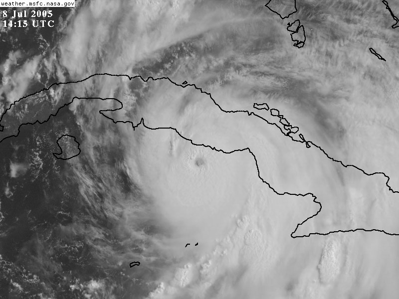
EARLY MORNING SATELLITE PHOTOGRAPH OF
DENNIS
So we watch and wait. I expect evacuation orders to be issued later today
or tonight. I have a place to stay a bit further down on the beach here in
Destin. I can stay at that location through Saturday Night and Sunday
Morning. The next location would be Panama City. I am not sure if
that is going to be evacuated or not. Will just have to wait and
see. My best bet is that Dennis moves into Southern Alabama/Southeast
Mississippi on Sunday. That would be the center of the storm.
No watches or warnings at this time for the Destin area.
UPDATED PRESSURE READING - 938 Millibars now reported by recon.
Morning Weather Observations from Destin
| METAR Observation for: | KDTS |
|---|---|
| Date/Time of Observation: | 8 July 2005, 10:53 UTC (8 July 2005, 06:53 EDT) |
| METAR Modifier: | Automated weather observation |
| Wind: | Calm |
| Visibility: | 10 sm (16.1 km) |
| Sky Conditions: | Sky clear |
| Temperature: | 24.0° C (75.2° F) |
| Dew Point: | 22.0° C (71.6° F) |
| Relative Humidity: | 89% |
| Altimeter: | 29.99" Hg (1015 hPa/mbar) |
10 a.m. Central Time UPDATE
DENNIS IS NEARING CATEGORY FIVE STRENGTH
AT 11 AM EDT...1500Z...THE CENTER OF
HURRICANE DENNIS WAS LOCATED NEAR LATITUDE 21.4 NORTH... LONGITUDE 79.9 WEST OR
ABOUT 130 MILES... 205 KM... WEST OF CAMAGUEY CUBA AND ABOUT 250 MILES... 405
KM...SOUTH-SOUTHEAST OF KEY WEST FLORIDA. WHILE SOME WOBBLING HAS OCCURRED...AS
IS TYPICAL OF A MAJOR HURRICANE...DENNIS IS EXPECTED TO CONTINUE MOVING TOWARD
THE NORTHWEST NEAR 15 MPH...24 KM/HR. ON THIS TRACK...THE CENTER SHOULD MAKE
LANDFALL ALONG THE SOUTH-CENTRAL COAST OF CUBA THIS AFTERNOON.
RECONNAISSANCE AIRCRAFT DATA INDICATE MAXIMUM SUSTAINED WINDS HAVE INCREASED TO
NEAR 150 MPH...240 KM/HR...WITH HIGHER GUSTS. DENNIS IS A STRONG CATEGORY 4
HURRICANE ON THE SAFFIR-SIMPSON SCALE. SOME WEAKENING IS FORECAST AS DENNIS
MOVES OVER CUBA...BUT IS EXPECTED TO REMAIN A MAJOR HURRICANE AS IT EMERGES OVER
THE STRAITS OF FLORIDA AND THE SOUTHEASTERN GULF OF MEXICO TONIGHT.
HURRICANE FORCE WINDS EXTEND OUTWARD UP TO 50 MILES... 85 KM... FROM THE
CENTER...AND TROPICAL STORM FORCE WINDS EXTEND OUTWARD UP TO 160 MILES...260
KM.
THE MINIMUM CENTRAL PRESSURE RECENTLY REPORTED BY AN AIR FORCE RESERVE HURRICANE
HUNTER AIRCRAFT WAS 938 MB...27.70 INCHES.
10 a.m. Satellite Photo of Dennis
CUBA RADAR 10 a.m.
Because of the intensity of Hurricane Dennis, Baldwin County emergency leaders have issued voluntary evacuations.
County leaders are asking all visitors to leave.
They are also asking people living in low lying areas or in mobile homes to find safer places to stay.
Baldwin County is west of this area.
11 a.m.
We are being told to evacuate by 9 a.m. tomorrow morning.
Friend just called and said that there was 150-200 police cars coming down Interstate 65 in Alabama. They were all heading south.
Friday Afternoon...
Total nightmare down here with traffic. You can't go anywhere. All lanes are blocked coming and going. Gas stations are out or running out of gas. There are long lines EVERYWHERE. Trying to call out on cell phones and getting all lines busy signal. A state of emergency has been issued for Florida.
Mandatory evacuation now for this area. Everyone has to leave. Not sure what we are going to do or what we are going to be able to do right now.
Friday Evening...trying to get out - have
stopped now at a place for the night. Have given up on trying to move
further.
What a total nightmare trying to get out of Destin, Florida. There was a mandatory evacuation order given and we had to leave by four pm. It took us from 5:00 p.m. till 8:15 p.m. to go TEN miles. We drove about 3 miles per hour. It was insane. There is NO gas in most of the areas we passed through. I became increasingly worried that we would not make it out with the amount of gas left in the tank.
Finally about 12 miles out of Destin the traffic started to flow a bit more. Ended up moving towards Panama City. Right now I am on the Bay here in the city. This area is being evacuated at 11 a.m. tomorrow morning. Not sure what happens at that point.
There is gas in this area.
There was also no phone service at any of the places we stopped. I could text message out and that was about it.
It has been a long evening. That is for sure. I feel sorry for anyone trying to leave major cities in a hurricane. I never thought there could be traffic moving that slow. We are stopping for the night to stay here. Not sure what we will do tomorrow. Depending on the traffic and the like. We may end up at a shelter.
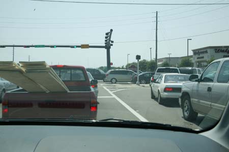
I did take a few photographs of Destin earlier today and then on the way here. Bumper to bumper.
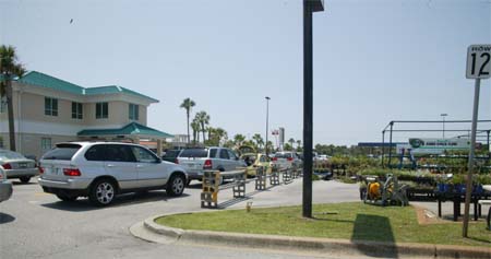
Line for gas...when there was gas earlier today.
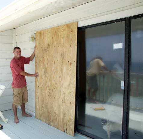
Boarding up the condo area.
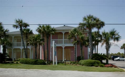
Houses boarded up.
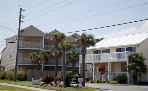
Boarded up houses in Destin.
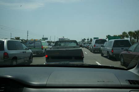
Long line of cars...for MILES
Evacuations are underway in Destin.
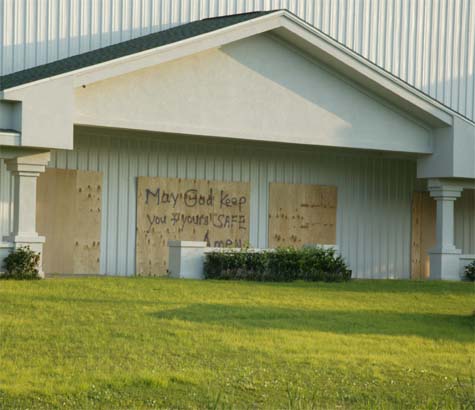
Church - May God Keep You Safe
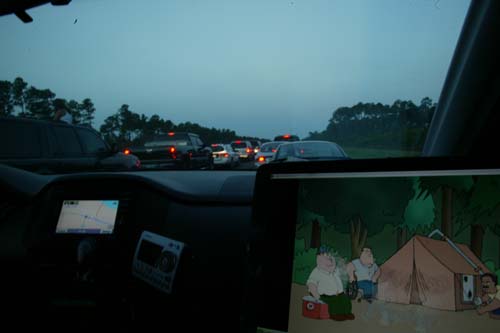
Road out of Destin...took three+ hours to go 10 miles.
Saturday...storm day
We are going to end up at a shelter.
Traffic is bumper to bumper throughout the area. Mandatory evacuation
orders continue for almost everyone along the coast here. I have
internet for a few hours then I won't be in contact online for at least 48 hours
or more.
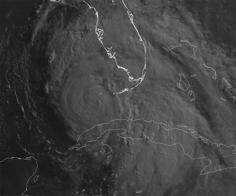
Morning Satellite image of Dennis
TURN THE PAGE CLICK HERE