
HOPKINS COUNTY, KENTUCKY

HOPKINS COUNTY, KENTUCKY
November continues...
ADDITIONAL TORNADO INFORMATION FROM THE PADUCAH, NATIONAL WEATHER
SERVICE
TORNADO MISSED MOTHERS HOUSE BY 2.31 MILES AND 3.5 MILES FROM DEENA AND TONY'S - THE METROPOLIS MESO MISSED MY PLACE BY 9 MILES!
ONE OF THE LONGEST TRACKED
TORNADOES IN RECENT MEMORY
F4 RATING - Tornado traveled more than 44 MILES
MOVED FROM GRAVES COUNTY...NEAR MAYFIELD ALL THE WAY INTO HOPKINS COUNTY, KENTUCKY.
Update (1 P.M. Monday 11/21): Investigation over the weekend confirmed mainly F-0 or F-1 damage along a path extending from central Graves County across the extreme northwest corner of Calloway County to near U.S. Highway 641, two miles south of Benton. In Graves County, the path of more significant damage begins about midway between Mayfield and Sedalia, then passes through the community of Golo in eastern Graves County. The continuity of the damage path was difficult to ascertain due to open fields and poor road access. Garages and barns sustained varying degrees of damage, and numerous trees were down. On the eastern end, damage surveys indicated the tornado crossed Lake Barkley, striking a subdivision and crossing Interstate 24 just southeast of Exit 45. Some of this damage appears to be F-2 intensity. The damage path ends near the community of Saratoga in Lyon County.
PUBLIC INFORMATION STATEMENT
NATIONAL WEATHER SERVICE PADUCAH KY
101 PM CDT MON NOV 21 2005
...UPDATED DAMAGE SURVEY RESULTS FOR GRAVES...MARSHALL...AND LYON
COUNTIES IN KENTUCKY AND LAND BETWEEN THE LAKES RECREATION AREA...
THE FOLLOWING IS AN UPDATED PRELIMINARY DAMAGE ASSESSMENT FOR THE
DAMAGE THAT OCCURRED OVER MARSHALL COUNTY KENTUCKY AND THE LAND
BETWEEN THE LAKES (LBL) RECREATION AREA ON NOVEMBER 15 2005.
* EVENT DATE: TUESDAY NOVEMBER 15 2005
* EVENT TYPE: F3 TORNADO
* EVENT LOCATION: FROM APPROXIMATELY 2.5 MILES SOUTH OF MAYFIELD
IN GRAVES COUNTY...THROUGH MARSHALL COUNTY AND THE LBL
RECREATION AREA...TO SARATOGA IN LYON COUNTY
* PEAK WIND: 200 MPH (PEAK WIND OCCURRED FROM BIG BEAR HIGHWAY TO
MOORS RESORT)
* AVERAGE PATH WIDTH: 275 YARDS. (TORNADO WAS CLOSE TO 500 YARDS WIDE
IN PLACES)
* PATH LENGTH: 44.1 MILES.
* INJURIES: 10
* FATALITIES: 1
* DISCUSSION/DAMAGE: ADDITIONAL SURVEYS WERE COMPLETED OVER THE
WEEKEND. THE TORNADO TOUCHED DOWN AROUND 145 PM NEAR THE SOUTH
HIGHLAND COUNTY CLUB IN SOUTH HIGHLAND IN GRAVES COUNTY. BY 2:15 PM
THE TORNADO WAS NEAR SLAUGHTER ROAD IMMEDIATELY EAST OF HIGHWAY 641
IN MARSHALL COUNTY...REACHED MOORS RESORT AROUND 2:25 PM...HILLMAN
FERRY CAMPGROUND AROUND 2:30 PM...AND THE EXTREME NORTHEAST CORNER
OF LBL AROUND 2:40 PM. THE TORNADO CONTINUED NORTHEAST AND LIFTED
NEAR SARATOGA IN LYON COUNTY AROUND 250 PM. DAMAGE RESULTS SO FAR
ARE AS FOLLOWS: 120 STRUCTURES RECEIVED DAMAGE...65 WITH MINOR
DAMAGE...36 WITH MAJOR DAMAGE...AND 19 DESTROYED.
$$
SHANKLIN/HOOPER/SPODEN

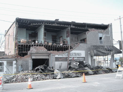
TREES SNAPPED OFF LIKE TWIGS...LOOKS FAMILIAR
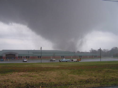
HOPKINS COUNTY, KENTUCKY
HOPKINS COUNTY, KENTUCKY

HOPKINS COUNTY, KENTUCKY

Marshall County, Kentucky

Marshall County, Kentucky November Tornadoes
Metropolis, Illinois Damage
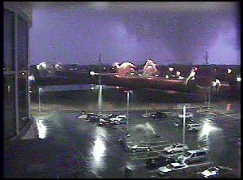
EVANSVILLE F3 TORNADO CAUGHT ON A WEB-CAM (the tornado
that struck before I left for Canada)
Photo of actual tornado taken by
webcam at Deaconess Women’s Hospital
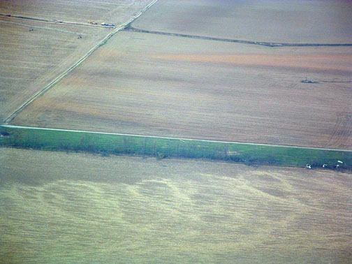
TORNADO TRACKS THROUGH A FIELD - EVANSVILLE TWISTER
NWS PHOTO
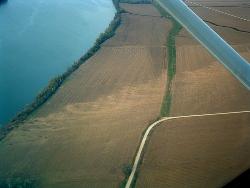
FIELD TRACKS...EVANSVILLE TORNADO - PADUCAH NWS PHOTO
THIS IS THE SECOND - YES SECOND - 40+ MILE TORNADO IN THE PAST TWO WEEKS! THAT IS AN INCREDIBLE STATISTIC. TORNADOES THAT TRAVEL THIS FAR ARE VERY RARE.
Recent tornadoes in historical perspective
The F-4 tornado that struck Hopkins County, Kentucky was the first F-4 tornado
in western Kentucky since April 3, 1968 and only the third since at least 1950.
The tornado fatality in Marshall County, Kentucky was the first tornado fatality
in western Kentucky since March 22, 1991. One person was killed then in a
tornado that tracked across Todd, Logan, and Warren Counties.
The F-3 tornado that struck the Evansville area caused the most fatalities in
the current Paducah NWS forecast area since May 21, 1949. An F-4 tornado on that
date killed 23 in Cape Girardeau County, MO and Alexander County, IL.
The F-3 tornado that struck the Evansville area tied the 1949 tornado as the
second deadliest in the Paducah NWS forecast area since the Great Tri-State
Tornado of 1925, which killed 695. The deadliest was on May 9, 1927 in the
Poplar Bluff, MO area. An F-4 tornado killed 98 as it tracked through Ripley and
Butler Counties in Missouri.
The Evansville area tornado was the first F-3 tornado to track through
Vanderburgh County since November 15, 1955...almost exactly 50 years ago to the
day.
The Evansville area tornado caused the first fatalities of any tornado that
tracked through Vanderburgh County since April 11, 1979.
Data prior to 1950 is unofficial data obtained from the publication Significant
Tornadoes, 1880-1989 Volume II: A Chronology of Events by Thomas P. Grazulis.
BREAKING NEWS
LUCY IS ALIVE!!!!
:)

LUCY LOOKING AS GOOD AS EVER...I BELIEVE SHE HAS GAINED
A FEW POUNDS.
Everything in Paducah is chaotic as ever. I won't
even begin to list of things that have gone wrong today. :) Tyler is
in the hospital. Everything around here is needing to have some attention
paid to it. I guess being gone awhile does that to everything from A to Z.
Much to do.
Tuesday...November 22, 2005
The Decorating begins :) Christmas lights go up today and start unpacking
everything else :) Should be fun.
Polar Express comes out today as well! YAY!
U
PDATE FROM THE NATIONAL WEATHER SERVICETWO TORNADOES TOUCHED DOWN IN McCracken County and Massac Counties
NEAR ROSSINGTON KENTUCKY 130 PM F0
MCCRACKEN COUNTY
2.5 W METROPOLIS - OHIO RIVER - 134 PM F0
MCCRACKEN COUNTY KENTUCKY/MASSAC COUNTY ILLINOIS
OKAY TURN THE PAGE FOR THANKSGIVING :) AND LIGHTS
See PADUCAH Live View Web-Cam Below
------------------------------------------------------
------------------------------------------------------
LIVE: VIEW
FROM DOWNTOWN PADUCAH
...VIA WEB CAM FROM WPSD NEWS CHANNEL 6

------------------------------------------------------
------------------------------------------------------
MAILING ADDRESS
BEAU DODSON
465 Ashcreek Road
Paducah, Kentucky
42001
-
Phone Number
Home 270-554-6715
Cell 270-970-1202
Email beaudodson@hotmail.com