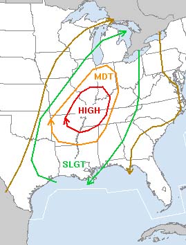
HIGH RISK OF TORNADOES -
STORM PREDICTION CENTER
NOVEMBER 15th TORNADO OUTBREAK
HIGH RISK OF TORNADOES -
STORM PREDICTION CENTER
There is a high risk of severe thunderstorms across my area through this afternoon and evening. Tornadoes are very likely in the high risk zone. This could be a very bad day back home.
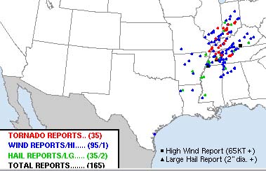
Preliminary Reports
Micro-Burst HAS HIT METROPOLIS...roof off of a building, glass blown out of businesses, buildings damaged - Methodist Church damaged
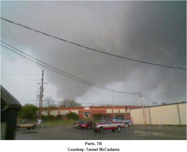
TORNADO HAS HIT PARIS, TN - 20 injuries - major damage
TORNADO HIT EDDYVILLE, KY - damage reported
TORNADO HIT CANNELBURG, IN - Many injured and major
damage
TORNADO HAS HIT CLARKSVILLE, TN - significant damage reported
TWO TORNADOES PASSED THROUGH GRAVES COUNTY, KENTUCKY
TORNADOES REPORTED NEAR MARION, ILLINOIS - minor damage
TORNADO HAS HIT EARLINGTON, KY - MAJOR DAMAGE
LILBOURNE, MO HIT BY A TORNADO...ROOF OFF A HOUSE
TORNADOES REPORTED NEAR JACKSON, MISSOURI - roof off of
building
TORNADOES REPORTED NEAR FRANKLIN, TENNESSEE -
MAJOR TORNADO DAMAGE REPORTED NEAR MADISONVILLE, KENTUCKY - Major damage
TORNADO HAS HIT BENTON (NORTH OF MURRAY) KENTUCKY 1 person killed - Major damage from a Multi-Vortex Tornado - lots of homes destroyed
TORNADOES HAVE HIT THE EVANSVILLE AREA
TORNADO IN EAST PRAIRIE, MISSOURI
TORNADO HAS HIT NEAR NEW MADRID, MISSOURI
TORNADOES HAVE HIT THE LOUISVILLE, KY AREA
DOZENS OF TORNADOES...Damage reported in many areas
MAJOR/HISTORIC TORNADO OUTBREAK HITS THE OHIO AND TENNESSEE VALLEYS
Numerous towns have been hit by tornadoes across portions of Missouri, Illinois, Indiana, Kentucky, and Tennessee.
Damaging winds have hit downtown Metropolis, Illinois - several businesses with major damage - no injuries reported
Tornado reportedly moved through Graves County, Kentucky and into Marshall County, Kentucky. Joey reports major damage in that area. Deena told me she went right under the wall cloud to get to the kids. She said it was eerie. You could almost touch the clouds. Lot of rotation.
We are going to have to push the weather radios harder.
NOVEMBER SEVERE WEATHER OUTBREAK
Wednesday, November 16, 2005
Much more quiet today than yesterday and that is a good thing. Ton of damage back in Western Kentucky and Western Tennessee...along with other areas. Thankfully everyone I know is okay and did not get much in the way of damage.
I have never seen so many tornadoes as in the past few years. Crazy stuff.
Toronto is going well. Had meetings today at Doug's Office and mother went shopping. :) Norman and Keri are getting ready for the big dinner on Friday. It should be lots of fun.
Mother and I are going to eat tonight with my friend Shawn. Should be a good evening.
Daviess County, Indiana, Tornado Photos from the
National Weather Service
F3 Tornadoes...
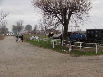
Indiana Tornadoes...
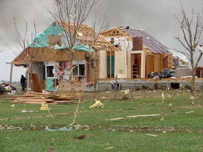
Indiana
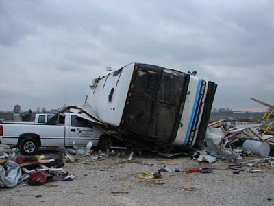
Indiana
Indiana...Daviess County
Damage Survey Results (as of 600 PM Wednesday, Nov. 16)
Owensville, Indiana (Gibson County) - Damage was result of microburst with 80 mph straight-line winds. Damage path 100 yards long and 50 yards wide. Time was estimated to be around 5:00 PM. Three mobile homes damaged.
Raleigh, Illinois (Saline County) - 1/8th of a roof peeled back off of church, other minor wind damage in the area.
Metropolis, Illinois (Massac County) - A microburst with wind speeds of 60-70 mph damaged a small area at 4th and Ferry Streets in downtown Metropolis. One brick wall of a structure crumbled and also sustained roof damage. An adjacent building suffered roof damage as well. A carport was blown into a church in the same vicinity. Time of the event: 3:30 PM CST.
Cobden, Illinois (Union County) - A microburst with wind speeds of 60-70 mph damaged several mobile homes. Two of the mobile homes had their roofs torn off, six others sustained minor damage. Several large tree limbs were down and a few trees were snapped off at their bases.
Lilbourn, Missouri (New Madrid County)- An F0 tornado touched down at 250 PM, three miles southwest of Lilbourn and traveled 1/4 mile before lifting. The peak winds were estimated to be 70 mph and the path width was 50 yards. Damage: An old equipment shed was destroyed. Near the shed, a couple of power lines were down and a good sized, but partially rotten tree was snapped off about halfway up. The damage was located on Highway 62, 3.5 miles west of the Highway 61/62 junction.
Lilbourn, Missouri (New Madrid County)- An F1 tornado touched down at 255 PM in the southwest corner of Lilbourn and traveled northeast approximately one mile before lifting south of Highway U near the railroad tracks. Peak winds were 80 mph and the path width was 75 yards. There were 2 minor injuries reported in Lilbourn. Damage: A couple of mobile homes were pushed off their foundations several feet. Several projectiles were embedded in one of the mobile homes. A considerable amount of debris was stuck in the trees in the area. Numerous trees were either topped out or blown down. A minivan was turned slightly while parked. A couple of small outbuildings were damaged or destroyed. Near the end of the tornado track...a couple of farm trailers and a couple of empty semi trailers were overturned.
Cayce, Kentucky (Fulton County)- A microburst with winds of 70 mph occurred at 120 PM, three miles southwest of Cayce along State Line Road. The damage was confined to a small area approximately 150 yards long by 50 yards wide. Part of the roof of a new steel farm equipment shed was blown off. The large sliding door on the windward side of the shed was also blown off. A couple of trees 100 yards downwind of the shed showed some minor damage.
Cayce, Kentucky (Fulton County)- A microburst with winds of 70 mph occurred at 125 PM, one mile south of Cayce. Damage was confined to a small area approximately 300 yards long by 50 yards wide. The damage was near the intersection of Highways 1128 and 239. Several trees were blown down. An old equipment shed that faced south and was open ended on that side, was rolled over and lodged against a row of trees immediately adjacent to it. Homes in the area were missing a few shingles. A poorly anchored carport was blown from its location approximately 100 yards downwind.
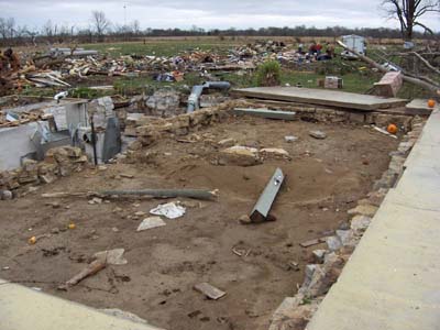
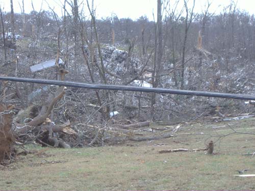
Aerial Survey Completed for Western Kentucky:
Two tornadoes were found. Both are potentially greater than F3, final determination of the rating will be available when the ground survey is completed.
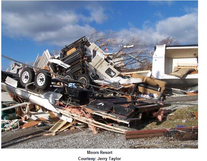
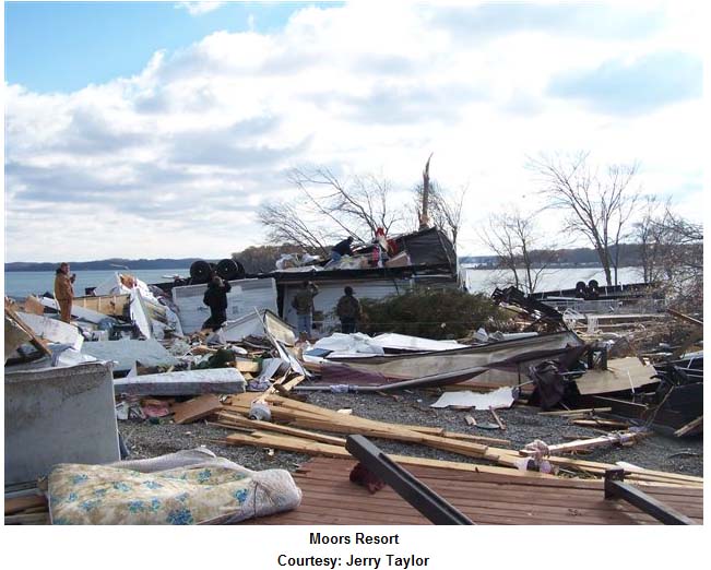
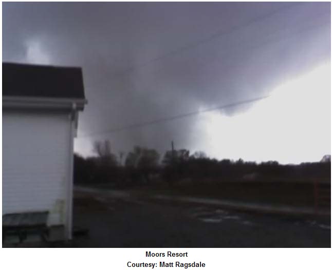
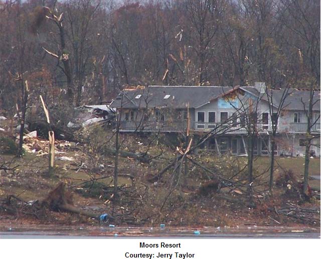
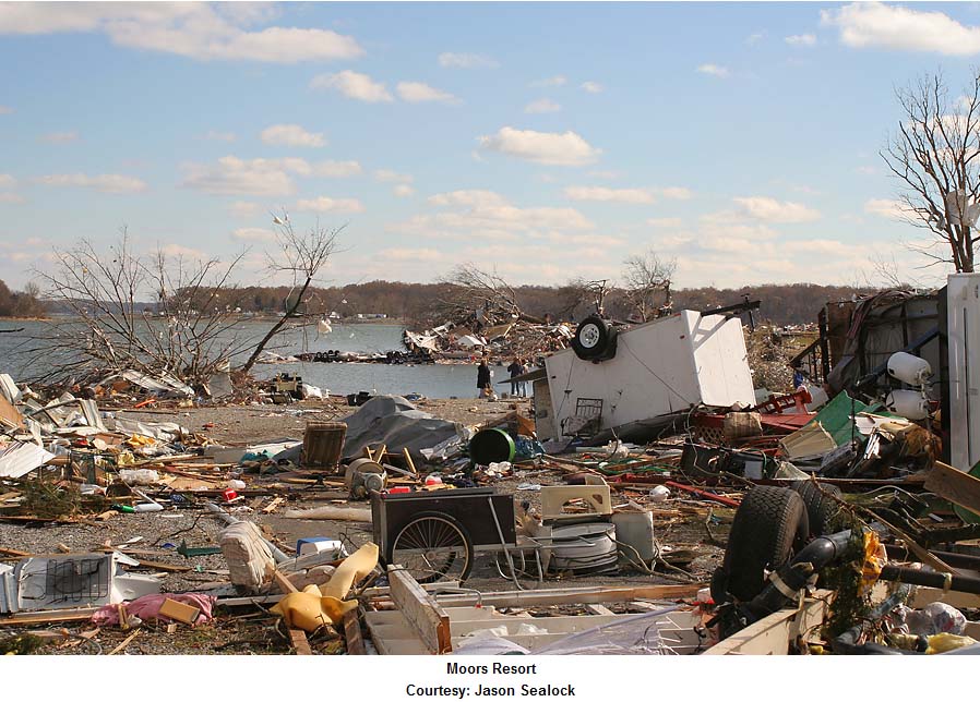
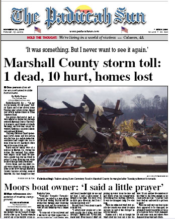
Marshall County - Preliminary path from 3.5 miles southwest of Benton to Moors Resort on Kentucky Lake.
10 injuries
Hopkins County - Preliminary path from 2.5 miles southwest of Earlington to just north of the Madisonville Municipal Airport to the Hopkins/McLean County line...about 5 miles west of Sacramento.
37 injuries, 2 critical
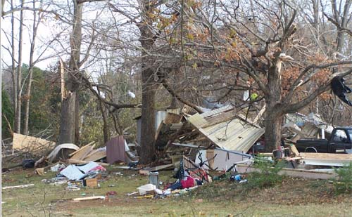
GRAVES AND MARSHALL COUNTY TORNADO
Photos below from WPSD TV 6 - this is the tornado and the storm that Deena drove through and passed over the kids school. Graves County was EXTREMELY fortunate this time around. The storm caused much more severe damage as it continued northeast into Marshall County.
These pictures below (most everyone from this area will know) is Moores Landing.
TORNADOES- WEST KENTUCKY
Soldiers
from Murray and Benton, Kentucky spent Tuesday searching for tornado survivors
in their own backyard. An F-3 tornado ripped an 8 mile long path of destruction
in Marshall County.
"It's nice to help everybody out, but when it's
closer to your home, it hits your heart a little more because you know most of
the people around," said Sergeant Merredeth Miller.
Soldiers went door to door looking for people
trapped in debris and offering assistance. They didn't find anyone with major
injuries, but they did find an amazing escape.
"(A dog) was on a chain in the ground.
Everything around him was destroyed," said Specialist James Jenkins.
"All he had was a little bump on the head, and he was just as playful as
ever."
The devastation off Big Bear Highway was
breathtaking. Homes were destroyed with few traces that they once stood. The
tornado scattered debris everywhere and snapped huge oak trees in half.
But this scene was nothing new for these soldiers.
They spent 30 days in Mississippi after Hurricane Katrina.
"It's a smaller scale than what we witnessed
down there," said 1st Sergeant Steve Berry. "As far as the type of
devastation there's not a lot of difference. It's exactly the same."
NEWS CHANNEL SIX IS NOW RUNNING THIS ON THEIR WEB SITE:)
http://www.wpsdtv.com/wxradio.html
The station called the other day and asked where we got the weather radios for the give away in 2004 - so they are now set up with a discount to sell NOAA Weather Radios from REECOM at a discount rate!!!!!
:) :) :) :) :) :)
Channel Six is going to keep this on their web site from here on out!
WPSD NewsChannel 6 and Reecom Electronics, Inc. are teaming up to offer weather radios for sale at a reduced price. These weather radios can be programmed to alert you at any hour of the day or night when the National Weather Service issues a warning for your community. They feature Digital S.A.M.E. All Hazard /Weather Alert technology with Amber Alert and EAS Alert Capabilities and time functions.Shown above is the Reecom R-1630 which usually sells
for $60.00. Through this special promotion with WPSD NewsChannel 6, you can
purchase this weather alert radio for $35.00.
Also available is the Reecom R-1650 which includes an additional AM/FM radio
built into the unit. It normally sells for $70.00. The WPSD price is $45.00.
To take advantage of the reduced price, you must download and fill out the WPSD
NewsChannel 6 order form.
Some new Shadow Angel projects are in about to be
announced. I am waiting to hear back from the NWS and Channel Six on final
plans for a new push on promoting NOAA Weather Radios!
A BIG THANK YOU TO THE PADUCAH NATIONAL WEATHER SERVICE AND NEWS CHANNEL SIX FOR ALL OF THEIR HARD WORK OVER THE PAST FEW WEEKS!!!!!
Had a wonderful time with Shawn and mother last night at a little restaurant in Cabbage Town.
Some pictures that Erick took from Tuesday night...

Doug, Erick, Me, Keri, and mother

Keri and mother in Toronto
------
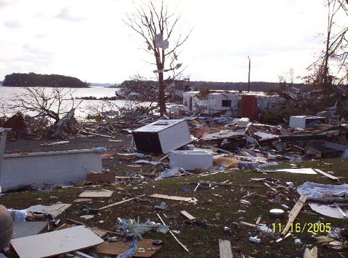
METROPOLIS, ILLINOIS
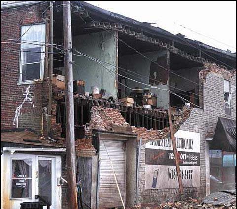
Damage from Monday's severe thunderstorms...Paducah Sun photo
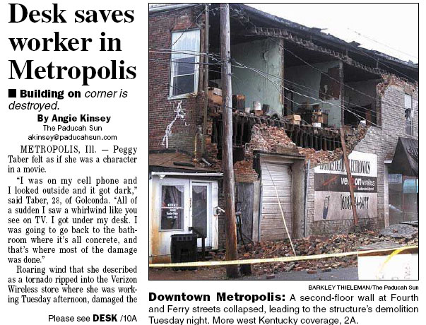
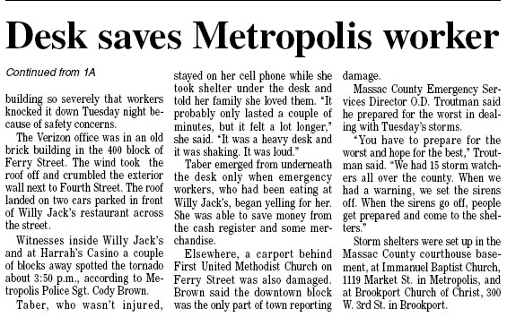
Paducah Sun - day after headlines
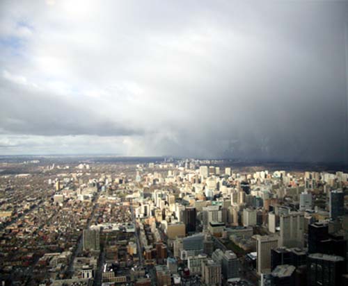
Thursday in Toronto :) SNOWING!
Fun day in Toronto :) Mother and I went to the CN Tower for lunch. We went Christmas shopping as well. It is SNOWING :) Just flurries though...but heh snow is snow! Hopefully we will get some more snow before we leave!
:)

Mother in front of the Iron Works Building...

Mother day dreaming at the CN Tower :)

Mom :)
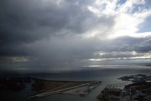
Snowing in the distance
Snowsqualls in the distance
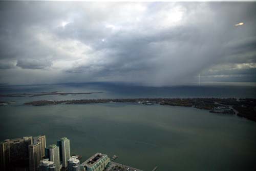
Lake Effect Snow on Lake Ontario

Lake Ontario, Canada
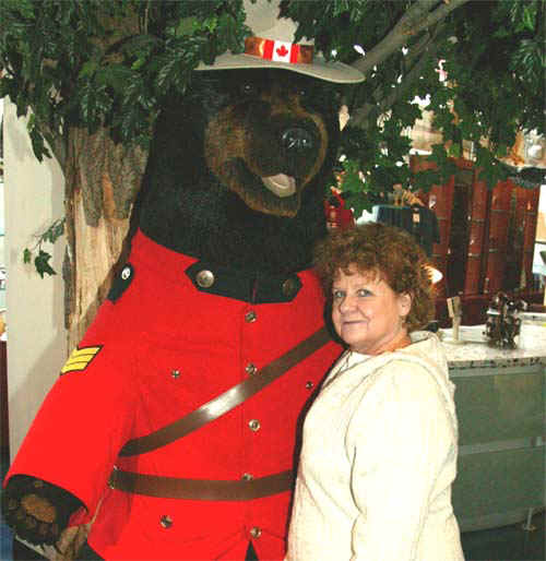
Mom hugging the local police bear :) hehe

Mom at the CN Tower in Toronto Canada :)
NEWS FROM PADUCAH...UPDATES
Just received news that the person killed in the Marshall County tornado was one of the Red Cross board members down there. Very sad news. Sue says that they expect to open up between 75-100 cases. A lot of homes destroyed...many of them are vacation homes though. Damage from the air looks bad. Here are some more NWS photographs that were just posted...the NWS will hold at news conference at 5 p.m today

Moors Marina - NWS Photo

Moors Marina - NWS Photo

Moors Marina - NWS Photo

Moors Landing - West Kentucky - WPSD TV Photo
West Kentucky - WPSD TV Photo
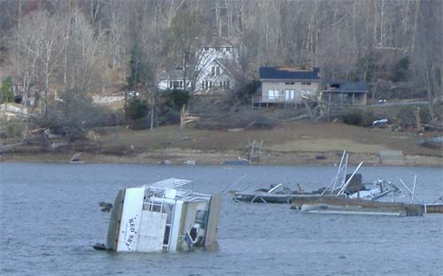
West Kentucky...Kentucky Lake - Moor's Landing - WPSD TV Photo
West Kentucky...Kentucky Lake - Moor's Landing - WPSD TV Photo
West Kentucky...Kentucky Lake - Moor's Landing - WPSD TV Photo
THREE MAJOR TORNADO OUTBREAKS IN THE LAST TWO
WEEKS...
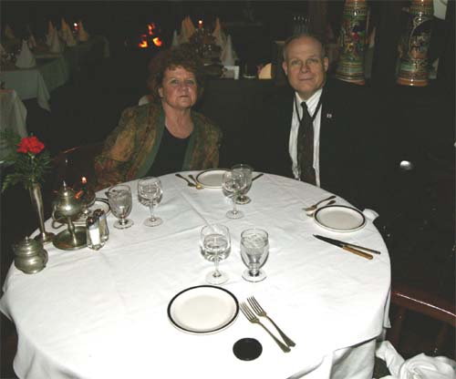
Mother and Norman at Carman's Restaurant
SNOWING IN TORONTO...THE GROUND IS ALMOST WHITE :) HEH - LIGHT SNOW BUT LOTS OF IT. WILL POST SOME PHOTOGRAPHS LATER!!!!
and
GAMMA forms in the Caribbean...heading for Florida? Hmmm
Photographs to boot :) CLICK HERE
See PADUCAH Live View Web-Cam Below
------------------------------------------------------
------------------------------------------------------
LIVE: VIEW
FROM DOWNTOWN PADUCAH
...VIA WEB CAM FROM WPSD NEWS CHANNEL 6

------------------------------------------------------
------------------------------------------------------
MAILING ADDRESS
BEAU DODSON
465 Ashcreek Road
Paducah, Kentucky
42001
-
Phone Number
Home 270-554-6715
Cell 270-970-1202
Email beaudodson@hotmail.com