EVERY COUNTY BUT ONE in Illinois has been declared a disaster area because of this drought.
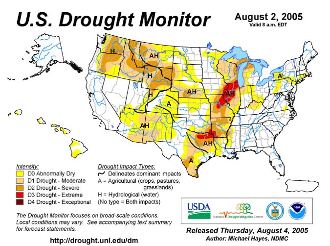
United States Drought Map - RED is EXTREME drought
AUGUST SIZZLES
Tuesday, August 9, 2005
HOT HOT HOT - HUMID HUMID HUMID! We can't escape this nasty air mass. We have been above 90 degrees for the past 9 days!
August 1 - 92 degrees
August 2 - 93 degrees
August 3 - 93 degrees
August 4 - 93 degrees
August 5 - 93 degrees
August 6 - 92 degrees
August 7 - 92 degrees
August 8 - 90 degrees
August 9 - ? We had 95 here in Lone Oak today
VERY HOT!
If we back up to July :) We had 15 days of 90 degrees and above!
June? We had 12 days above 90 degrees!
May had one day above 90 degrees.
More than 1/2 of our rainfall has come from the tropical systems. Had we not had rain from the tropical storm and hurricane then we would be extremely dry. It is still dry here. Severe drought north and west of here. Most of Illinois is in severe drought. Crops have failed in most areas. Thankfully we have had some rain here in Western Kentucky.
EVERY COUNTY BUT ONE in Illinois has
been declared a disaster area because of this drought.
United States Drought Map - RED is EXTREME
drought
Tuesday Continued...
So anyhoo yada yada yada - dry and hot weather seems to be the song and dance for this summer. I am missing CANADA! I hear that it is just as hot up there. I still miss Canada :) heh Nothing beats the fall leaves and the first snowfall in Ontario. Nothing REALLY beats the old cottage up there. I always day dream of that place. It really was heaven on earth. I will have to find someplace like that in Vermont or New Hampshire. Somewhere where it snows a lot! hehe I am sure there are plenty of places up that way. Need to do some scouting I guess.
Good grief...I need my Kristy update. She is moving to a new job soon and so she has not been online as much. I guess my LUCY UPDATES will have to wait a little while longer :( MISS YOU KRISTY! :)
A new logo for Shadow Angel is in the works :) I am excited...the first drafts are awesome. I would post them but I think I will wait for the finished product. A local artist is creating the logo and the symbol for Shadow Angel. :) This will replace the kneeling angel that I have been using. :)
Life is moving along...faster than I would like. It seems like time just gets faster and faster and faster. Lots to do and lots being accomplished down here. The Red Cross Disaster work is coming along nicely. Several more meetings on Thursday and then a few next week. Slowly the plan is coming together.
Wednesday, August 10, 2005
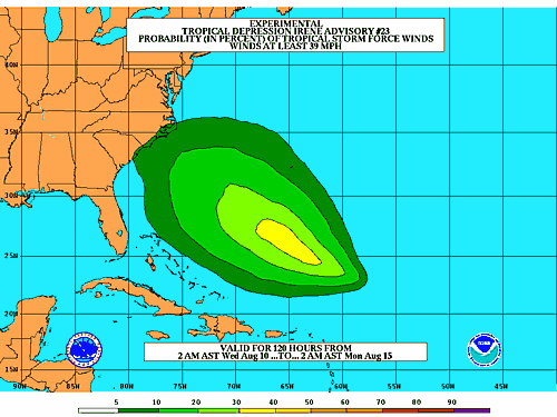
TROPICAL DEPRESSION IRENE
Although Irene continues to weaken and is now
a tropical depression, I still believe that she will regain strength and pose a
threat to the United States. As I mentioned last Thursday - keep your eyes
on Irene. She has potential to cause major problems to portions of the
United States. She could be a big one. Time will tell. Many
forecasts said she would not make it this far or would curve out to sea.
She continues to move towards the United States.
BULLETIN
TROPICAL DEPRESSION IRENE ADVISORY NUMBER 24
NWS TPC/NATIONAL HURRICANE CENTER MIAMI FL
11 AM AST WED AUG 10 2005
...IRENE GETTING A LITTLE BETTER ORGANIZED OVER THE OPEN ATLANTIC...
AT 11 AM AST...1500Z...THE CENTER OF TROPICAL DEPRESSION IRENE WAS
LOCATED NEAR LATITUDE 22.4 NORTH... LONGITUDE 57.7 WEST OR ABOUT
810 MILES...1305 KM... SOUTHEAST OF BERMUDA AND ABOUT 455 MILES...
730 KM...NORTHEAST OF THE NORTHERN LEEWARD ISLANDS.
THE DEPRESSION IS MOVING TOWARD THE WEST NEAR 10 MPH...17 KM/HR...
AND THIS GENERAL MOTION IS EXPECTED TO CONTINUE FOR THE NEXT 24
HOURS.
MAXIMUM SUSTAINED WINDS ARE NEAR 35 MPH... 55 KM/HR...WITH HIGHER
GUSTS. SOME STRENGTHENING IS FORECAST DURING THE NEXT 24 HOURS...AND
IRENE COULD REGAIN TROPICAL STORM STATUS LATER TODAY OR THURSDAY.
THE ESTIMATED MINIMUM CENTRAL PRESSURE IS 1009 MB...29.80 INCHES.
REPEATING THE 11 AM AST POSITION...22.4 N... 57.7 W. MOVEMENT
TOWARD...WEST NEAR 10 MPH. MAXIMUM SUSTAINED
WINDS... 35 MPH. MINIMUM CENTRAL PRESSURE...1009 MB.
THE NEXT ADVISORY WILL BE ISSUED BY THE NATIONAL HURRICANE CENTER
AT 5 PM AST.
FORECASTER STEWART
------------------------------
BREAKING NEWS
RECORD OIL PRICES LEAD TO PRESIDENTIAL ANNOUNCEMENT
BUSH TO INVADE
CANADA

DATELINE - AUGUST 10, 2005
Ashcreek News
(AN) Amid rising oil prices and consumer lash back George Bush announced new
measures today to bring down the price of oil for Americans. We will
invade Canada. The U.S. government said Thursday that Canada holds the
world's second-largest oil reserves, taking into account Alberta Oil sands
previously considered too expensive to develop. Bush says that he believes
that with these reserves we could bring the price of oil back down to $30 US a
barrel. Levels are currently nearing $65 US a barrel.
Bush continued to maintain that Canada is "a central front in the war for oil." How did he prove this case? He quoted the President of Canada Paul Martin, who once said, "America wishes it had the oil reserves we have...they need our oil." Bush believes that statement alone proves that they have the oil we need. Bush also said that Canada could post a military threat in the future and could one day attack us ( although apparently not only does Canada not have weapons of mass destruction they also don't even have a real army... although Bush swore he once saw an airplane with a Canadian flag on it). He went on to say that we would "SMOKE THEM OUT OF THEIR IGLOOS"
Bush said that Canada would become the 51st state, Bush said that we would name the state USANADA. Thus preserving the rich heritage that Canada believes that it holds. President Bush said that since Canada was part of South America that he hoped to one day visit the rainforests of Ontario and would be thrilled to see the polar bear monkeys that he has heard so much about.
Canadians had mixed views on the invasion. Many were happy to hear that they would have more access to guns, drugs, and violent video games. Canadians also said that they would finally have a "real military" with which they could invade other countries around the world - thus helping them to spread freedom and democracy. Thus achieving their long term goal of world domination.
Not all Canadians were happy though. At least one Canadian was against the invasion.
President Bush said that America would force freedom upon Canada. He said that Canadians would finally be free. Free from their health care system, free from their liberal politicians, and free from clean air and water. We will force Canadians to be happy. Something everyone in the universe would like to be...said President Bush.
Bush told Canadians that once freedom was forced upon them that they would also be forced to watch FOX News as their new choice for information. "Fox news doesn't distort or change the truth...they are the truth" Present Bush said earlier today. Demoilcracy errr Democracy is on the move!
Beau Dodson reporter at large
Thursday, August 11, 2005
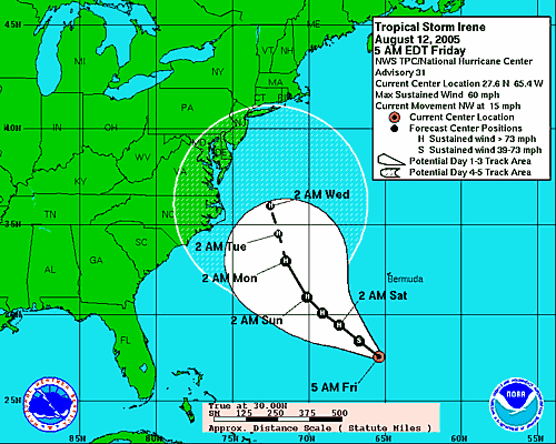
Still watching Irene. It appears that Irene is slowly getting better organized. I still believe there is a threat to the Southeast United States. The latest track from the National Hurricane Center is starting to show that Irene may not curve out to sea. Lots of time to watching this one.
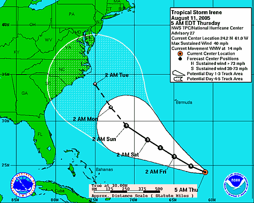
NHC PREDICTED TRACK OF IRENE
Thursday Afternoon...
Being put on the standby list for Tropical Storm Irene. She continues to gain strength this afternoon and is heading for the Southeast United States and the Middle Atlantic. If Irene curves then the Northeast United States could feel her impact as well.
BULLETIN
TROPICAL STORM IRENE ADVISORY NUMBER 29
NWS TPC/NATIONAL HURRICANE CENTER MIAMI FL
5 PM AST THU AUG 11 2005
...IRENE CONTINUING TO GRADUALLY GET BETTER ORGANIZED...
AT 5 PM AST...2100Z...THE CENTER OF TROPICAL STORM IRENE WAS LOCATED
NEAR LATITUDE 25.7 NORTH... LONGITUDE 63.9 WEST OR ABOUT 460
MILES... 740 KM... SOUTH OF BERMUDA AND ABOUT 950 MILES...1530
KM...SOUTHEAST OF CAPE HATTERAS NORTH CAROLINA.
IRENE IS MOVING TOWARD THE WEST-NORTHWEST NEAR 15 MPH...24 KM/HR.
THIS GENERAL MOTION...WITH A GRADUAL DECREASE IN FORWARD SPEED...
IS EXPECTED TO OCCUR FOR THE NEXT 24 HOURS.
MAXIMUM SUSTAINED WINDS ARE NEAR 50 MPH... 85 KM/HR...WITH HIGHER
GUSTS. SOME STRENGTHENING IS FORECAST DURING THE NEXT 24 HOURS.
TROPICAL STORM FORCE WINDS EXTEND OUTWARD UP TO 60 MILES
... 95 KM FROM THE CENTER.
THE ESTIMATED MINIMUM CENTRAL PRESSURE IS 1000 MB...29.53 INCHES.
REPEATING THE 5 PM AST POSITION...25.7 N... 63.9 W.
MOVEMENT
TOWARD...WEST-NORTHWEST NEAR 15 MPH. MAXIMUM SUSTAINED
WINDS... 50 MPH. MINIMUM CENTRAL PRESSURE...1000 MB.
THE NEXT ADVISORY WILL BE ISSUED BY THE NATIONAL HURRICANE CENTER
AT 11 PM AST.
FORECASTER STEWART
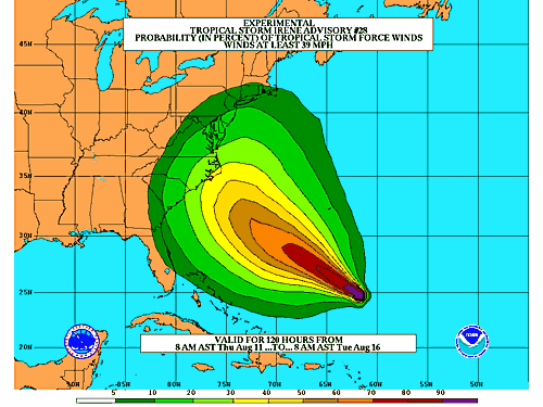
LATEST FORECAST TRACI WITH WIND FIELDS
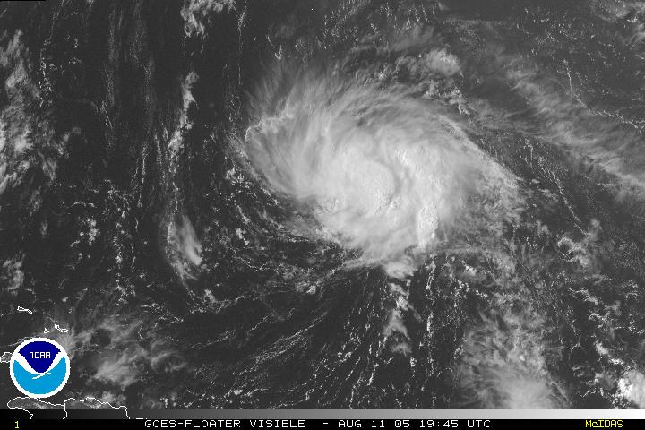
5 p.m. Satellite Photograph of Tropical Storm Irene
Perseid Meteor Shower Tonight! Very nice fireballs screaming from north to south here in Western Kentucky! I was able to see one red one. Several large fireballs already. Pretty kewl stuff!
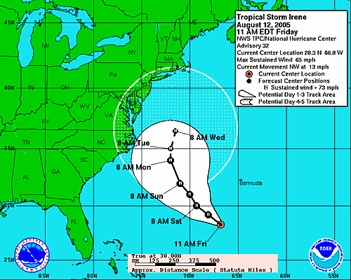
Friday, August 12, 2005
There are indications that Irene will come
close to the coast and then start to recurve. Going to be a VERY close
call for the Eastern United States. Many storms seem to recurve in this
area of the Atlantic. Hopefully she won't hit the United States. I
would imagine many areas could use the rain though.
BULLETIN
TROPICAL STORM IRENE ADVISORY NUMBER 31
NWS TPC/NATIONAL HURRICANE CENTER MIAMI FL
5 AM AST FRI AUG 12 2005
...IRENE STRENGTHENING...CENTER RE-LOCATED A LITTLE TO THE EAST...
DATA FROM SEVERAL MICROWAVE SATELLITES INDICATE THAT THE CENTER OF
IRENE IS SOMEWHAT TO THE EAST OF THE PREVIOUS ADVISORY POSITION.
AT 5 AM AST...0900Z...THE CENTER OF TROPICAL STORM IRENE WAS LOCATED
NEAR LATITUDE 27.6 NORTH...LONGITUDE 65.4 WEST OR ABOUT 325
MILES... 525 KM...SOUTH OF BERMUDA AND ABOUT 795 MILES...1275
KM...SOUTHEAST OF CAPE HATTERAS NORTH CAROLINA.
IRENE IS MOVING TOWARD THE NORTHWEST NEAR 15 MPH...24 KM/HR...AND
THIS GENERAL MOTION IS EXPECTED TO CONTINUE WITH A DECREASE IN
FORWARD SPEED DURING THE NEXT 24 HOURS.
MAXIMUM SUSTAINED WINDS HAVE INCREASED TO NEAR 60
MPH... 95
KM/HR...WITH HIGHER GUSTS. ADDITIONAL STRENGTHENING IS FORECAST
DURING THE NEXT 24 HOURS.
TROPICAL STORM FORCE WINDS EXTEND OUTWARD UP TO 60 MILES
... 95 KM FROM THE CENTER.
ESTIMATED MINIMUM CENTRAL PRESSURE IS 997 MB...29.44 INCHES.
REPEATING THE 5 AM AST POSITION...27.6 N... 65.4 W. MOVEMENT
TOWARD...NORTHWEST NEAR 15 MPH. MAXIMUM SUSTAINED
WINDS... 60 MPH. MINIMUM CENTRAL PRESSURE... 997 MB.
THE NEXT ADVISORY WILL BE ISSUED BY THE NATIONAL
HURRICANE CENTER AT 11 AM AST.
Forecast will take Irene close to the Southeast Coast
with a curve towards the end
of the forecast. New England isn't out of the woods yet.
NOON
Latest Forecast track is showing out to sea. Going to be a close call for the Southeast United States and the Middle Atlantic.
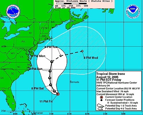
Saturday Morning...
Irene is nearing hurricane strength. She continues to move towards the west and northwest. She should continue this path for the next day or so and then turn more towards the north. Hopefully this means she will brush the southeast coast but not make a direct hit.
HOW HIGH WILL IT GO???? Gas is up to
2.46 here in Paducah now! That is the CHEAPEST gas. INSANE!
Hmmm how long until we have $3.00 a gallon gas? EEK
Saturday Late Morning...
Well I think Irene is definitely going to re-curve. I thought she might hit the Eastern Seaboard but that thankfully is not going to happen. Many of these storms that move through that region of the Atlantic tend to re-curve right before they hit land. Irene will go down in the books as one of those. The next tropical storm is developing way out in the Atlantic. This would be our 10th named storms...once it is named. Active season.
So say goodbye to Irene. She won't be hitting the United States.
:)
Showers and thunderstorms will become likely across this region over the next few days. Very heavy rain is likely with some of the storms. We could see several rounds - if we are lucky! We could use the relief. Heavy rains fell overnight across much of Missouri and Illinois. Those areas are in severe drought. It is prob way too late for the crops though. Most of the crops have already been destroyed by the drought.
I believe this is day 14 of 90+ degree weather.
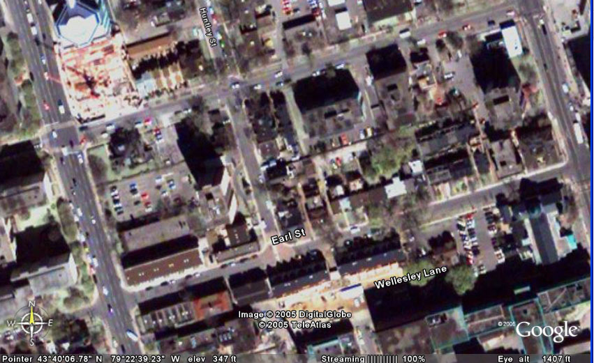
Using this new google.earth program :) I found Earl Street - see if Doug and Erick can find their house!
NORMAN'S PLACE :) - you can see the gardens and park across the street from his place!

Now I have to find Davids :)
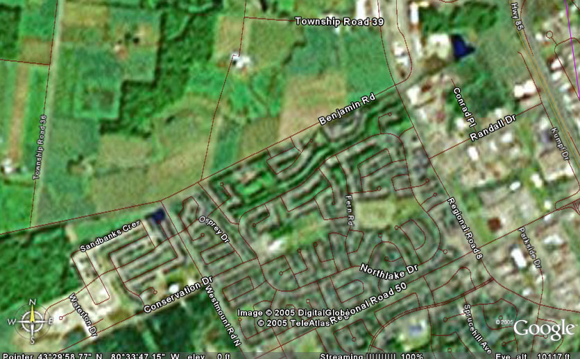
David :) - you can see the farm next to your place :)
MOO MOO
:)
I won't put exactly where everyone is...in case the paparazzi
starts looking around.
Sunday, August 14, 2005
Finally some rain is coming. Looks like showers and heavy thunderstorms for the next several days. Some areas could see very heavy rainfall totals. 1-3 inches of rain is not out of the questions as slow moving storms roll across the area. Severe thunderstorms are likely as well. High winds in excess of 60 miles per hour will be the main threat from the thunderstorms.
DROUGHT 2005
SEVERE DROUGHT NOW IN WESTERN KENTUCKY.
RIVER LEVELS ARE VERY LOW. SOME OF THE LOWEST LEVELS IN YEARS. RIVER
TRAFFIC HAS BEEN BANNED IN SOME AREAS.
EXTREME DROUGHT CONTINUES ACROSS MUCH OF
ILLINOIS AND INTO MISSOURI.
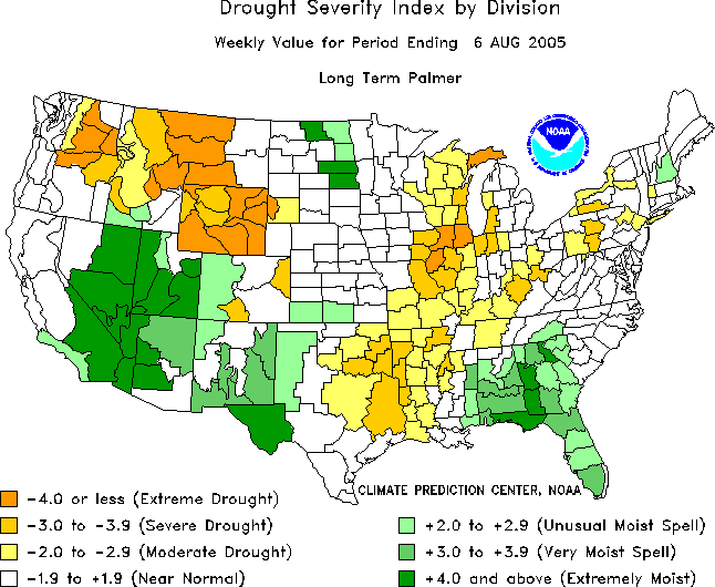
PALMER DROUGHT INDEX MAP - Most of Kentucky is
now in moderate to severe drought.
NATIONAL WEATHER SERVICE PHOTOGRAPH
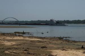
OHIO RIVER IS VERY LOW
Today will be the 15th day in a row that we have been above 90 degrees. Temperatures have been near 100 or over 100 degrees over the past week.
| Public Information Statement, Issued by NWS Paducah, KY |
1143 AM CDT FRI AUG 12 2005 THE ENVIRONMENTAL AND PUBLIC PROTECTION CABINET IS ANNOUNCING A WATER SHORTAGE WATCH FOR THE BLUEGRASS, CENTRAL AND WESTERN REGIONS OF KENTUCKY. A WATER SHORTAGE WATCH INDICATES AN INCREASED CHANCE FOR WATER SHORTAGES TO OCCUR IN A GIVEN AREA. A WATCH IS A RECOMMENDATION FOR PLANNING, PREPARATION AND AWARENESS OF THE DROUGHT CONDITIONS AND IMPACTS TO LOCAL WATER SOURCES. WATER SUPPLIERS IN THE WATCH AREA SHOULD BEGIN TO MONITOR WATER SUPPLIES CLOSELY AND NOTIFY THE DIVISION OF WATER AS WATER SHORTAGE ADVISORIES ARE ISSUED. DROUGHT CONDITIONS HAVE BEEN DEVELOPING ACROSS MOST OF KENTUCKY SINCE THE BEGINNING OF MAY. AUGUST AND SEPTEMBER ARE NORMALLY THE HOTTEST AND DRIEST MONTHS OF THE YEAR. MANY AREAS ARE VERY SHORT OF SOIL MOISTURE AND ALREADY EXPERIENCING DECREASED GROUNDWATER STORES AND DECLINING STREAMFLOWS. A COMBINATION OF DROUGHT INDICATORS INCLUDING RAINFALL, STREAMFLOWS AND THE PALMER DROUGHT INDEX, HELP TO QUANTIFY THE CURRENT SEVERITY OF DROUGHT CONDITIONS FOR EACH OF THE FOUR CLIMATIC DIVISIONS. THE INDICATORS ESTABLISH THE DROUGHT STATUS AS SEVERE FOR THE BLUEGRASS, CENTRAL AND WEST DIVISIONS AND MILD FOR THE EAST. |
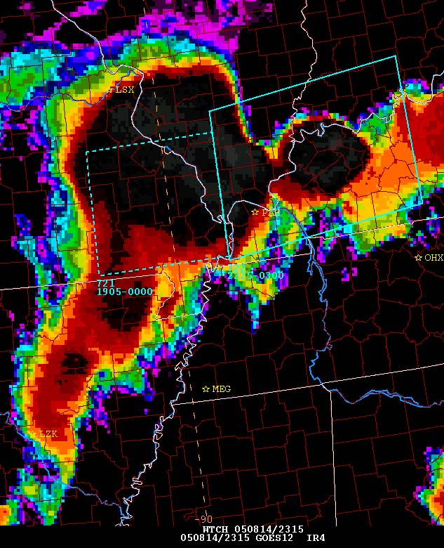
TROPICAL STORM IRENE
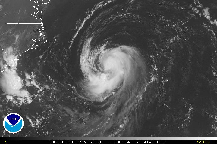
TROPICAL STORM IRENE - SUNDAY MORNING - SPINS RIGHT OFF THE SOUTHEAST COAST
--------
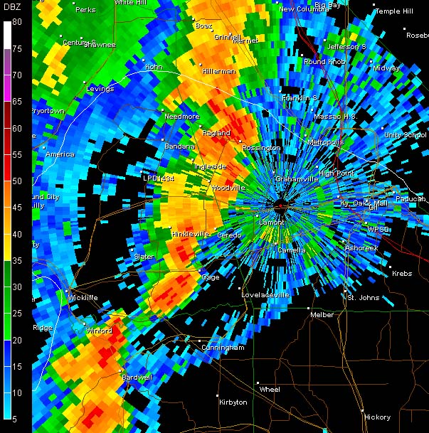
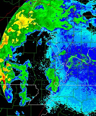
Heavy thunderstorms here in Lone Oak this evening.
Lots of rain and lightning. NWS Radar shows the heavy storms moving in.
Lots of severe weather reported across Southeast Missouri and Southern Illinois.
Numerous reports of wind damage.
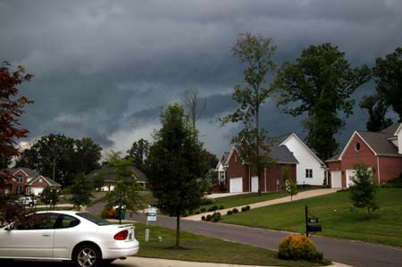
Stormy sky this evening
SATELLITE PHOTO SHOWS THE BIG STORM COMPLEX OVER THIS REGION
Monday, August 15, 2005
Day sixteen of 90-100 degree weather! It started out cool this morning with lots of clouds but that quickly went by the wayside. Sun is shining brightly now and it is extremely humid. It appears that more strong thunderstorms are going to move into this area later this afternoon. A chance for some severe thunderstorms again.
-------------
Thunderstorms here this evening. We picked up around 0.50" of rain in 30 minutes! Not too bad!!!! Lots of lightning...cloud to ground lightning in the neighborhood. Ton of rain moving in from the west tonight! Radar looks GREAT! BRING IT ON!
Radar shows heavy thunderstorms moving in from the
west as if 9 p.m.
7.2 Earthquake Rocks Japan - Tuesday Morning (Monday Night here)
Many people were reported injured in the coastal city of Sendai, Kyodo News Agency said, but national broadcaster NHK reported, citing city officials, only objects falling from bookshelves and no major damage.
The quake was centered nearly 13 miles beneath the ocean off the coast of Miyagi prefecture in northeastern Japan, NHK said, citing the nation's Meteorological Agency. The quake hit around 11:46 a.m. local time.
A 20-inch tsunami was expected to reach Japanese shore about 15 minutes after the quake struck, NHK reported.
The U.S. Geological Survey registered the quake with a 7.2 magnitude.
Japan sits at the juncture of four tectonic plates – or moving slabs of the earth's outer crust – and is one of the world's most quake-prone regions.
A magnitude-6.0 quake shook the Tokyo area on July 23, injuring more than two dozen people and suspending flights and trains for hours. A magnitude-5 quake can damage homes and other buildings if it is centered in a heavily populated area.
A Dec. 26 earthquake with a magnitude estimated at 9.1 to 9.3 and the subsequent tsunami killed more than 131,000 people in Indonesia and left half a million homeless. Three months later, another strong temblor left more than 900 dead on Nias and smaller surrounding islands.
Tuesday, August 16, 2005
Lots of lightning and thunder this morning in Paducah! Woke up around 3 a.m. to flashes of lightning. It rained for about a couple of hours. Looks like we picked up at least another 0.86" of rainfall! That is pretty good. Around 1.30" in the past 24 hours.
I am helping to teach a Red Cross class tonight...Intro to Disaster.
BREAKING 90 AGAIN
Another 90 degree day here. We briefly hit 90 this afternoon. DAY SEVENTEEN of 90 degrees and above!!!! EEK on that! I don't like the hot weather...ENOUGH already!
Gas is over $2.55 now! It just keeps going higher.
Wednesday, August 17, 2005
We had numerous thunderstorms last night. I was at the Red Cross and there was a lot of lightning and thunder. VERY heavy rains moved across portions of Western Kentucky. Storms moved out by late evening. We have a ton of clouds this morning. Looks like we are going to have a cloudy day with temperatures not able to reach 90 degrees. HOPEFULLY we can enjoy at least one day of cooler temperatures.
There could be some severe thunderstorms on Thursday. There is a risk of supercell thunderstorms across portions of the area. Will have to keep an eye on this situation. There is the potential for tornadoes.
I am on my way to the Red cross to work on shelter kits.
Wednesday Evening...
All is well. Kristy you out there????
Still debating the whole Mount Washington thing. I really want to see Maine as well. :) September perhaps.
Written by Lesly C. Simmons , Staff Writer, RedCross.org
Tuesday, August 16, 2005 — The small town of Wright, Wyo. is getting help from the American Red Cross after a tornado struck a trailer park on Friday, killing two and injuring at least a dozen others.
"This tornado was very destructive, and pinpointed," said Red Cross spokesman Peter Macias, who arrived in Wright on Monday. "It struck a trailer home park and left more than 100 homes uninhabitable."
 Friday's tornado destroyed a trailer park in the small community of Wright, Wyo. (Photo credit: WPBF News). |
The F2 tornado struck with little warning, leaving most of the town's 1800 residents with no time to move to shelter. The National Weather Service said the tornado that struck Wright was a F2 category twister with winds estimated at 113 to 130 mph.
About one hundred residents are unable to return to their own homes, so they are staying with family or friends.
"This community is so tight knit that we've had a shelter open but it's only had a few residents," said Macias. "People here have family and friends to stay with, and everyone is taking care of each other."
The Red Cross started outreach efforts over the weekend, opening mental health and assistance cases for nearly 200 people, while coordinating with state and local officials to make sure everyone's needs are being met.
"We've all been so impressed by the speed and the dedication the citizens of Wright, and of the volunteers who've come to help," said Macias.
Volunteers from local Red Cross chapters have been making the rounds delivering food to residents and emergency crews. Nearly 50 Red Cross staffers from seven states have joined the relief effort.
Thursday, August 18,2005
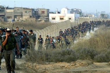
ISRAEL AT WAR WITH ITSELF
This is all very sad. Most people in Israel believe that the Palestinians SHOULD have a state. This is the path to that state. As hard as it is...this is the path. Some believe that the Palestinians will never stop...they won't stop at the Gaza or at the West Bank. They will keep wanting more and more. The world hopes that is not true.
Photographs from different news agencies
from yesterday and today.

A Jewish settler woman shouts as she holds her child while being escorted out of the Jewish settlement of Shirat Hayam in the Gush Katif bloc of settlements in the Gaza Strip Thursday Aug. 18 , 2005. Hundreds of soldiers on Thursday broke into the beachside Shirat Hayam outpost, one of Gaza's most hardline Jewish

A Jewish settler woman prays as soldiers surround the
synagogue in the Neve Dekalim settlement in the Gush Katif bloc of Jewish
settlements, southern Gaza Strip, August 18, 2005.
Israeli security forces advance towards the Jewish
settlement of Kfar Darom during the forced evacuation of settlers from the
southern Gaza Strip settlements, Thursday, Aug. 18, 2005.

A settler gestures from a rooftop at Israeli troops
approaching the Jewish settlement of Netzer Hazani, in the Gush Katif bloc of
settlements, in the southern Gaza Strip, Thursday Aug. 18, 2005.

Jewish settlers, some wearing Israeli flags, dance and sing in front of Israeli soldiers and police officers outside the synagogue of the Jewish settlement of Neve Dekalim, southern Gaza Strip, Thursday, Aug. 18, 2005.

Israeli soldiers carry a Jewish settler to be evacuated
from the Jewish settlement of Kfar Darom, in the southern Gaza Strip, Thursday
Aug. 18, 2005.

A Palestinian flag flies in front of an Israeli tank guarding the Jewish
settlement of Ganei Tal in the southern Gaza Strip August 18,2005

An Israeli soldier overcome by emotion wipes tears from
his eyes as Israeli police and army enter the Jewish settlement of Netzer Hazani,
in the Gush Katif bloc of settlements, in the southern Gaza Strip Thursday Aug.
18, 2005.

Israeli female soldiers taking part in the uproot of settlers cry in the
southern Gaza Strip settlement of Neve Dekalim.

A Jewish settler child cries as his family is evacuated
from their home by Israeli soldiers from the Jewish settlement of Neve Dekalim,
part of the Gush Katif settlement bloc in Gaza Strip August 17, 2005

An Israeli soldier carries a weeping child in his arms as he and other members
of his unit forcibly evacuate a family of settlers in the Neveh Dekalim
settlement in the Southern Gaza Strip.(AFP/David Furst)

A Palestinian boy, relative of one of three Palestinians gunned down by a Jewish
settler, cries at the entrance of the West Bank settlement of Shilo, north of
Ramallah Wednesday, Aug. 17, 2005

Israeli troops drag a Jewish settler out his house, as he attempts to resist the
forced evacuation of the Jewish settlement of Neve Dekalim, in the Gush Katif
bloc of settlements, in the southern Gaza Strip Wednesday, Aug. 17, 2005.

A weeping Israeli police officer is comforted by a fellow policeman as they take
part in the forced evacuation of settlers in the Jewish settlement of Neve
Dekalim, in the southern Gaza Strip Wednesday, Aug. 17, 2005

A Palestinian boy runs with a Palestinian flag in front
of the Israeli settlement of Morag, on the outskirts of Rafah, in the southern
Gaza Strip, Wednesday, Aug. 17, 2005
THURSDAY SEVERE WEATHER...
Destructive tornadoes are hitting Wisconsin this afternoon. Powerful
storm system has produced at least several strong tornadoes. Numerous
injuries have been reported along with widespread damage to homes.
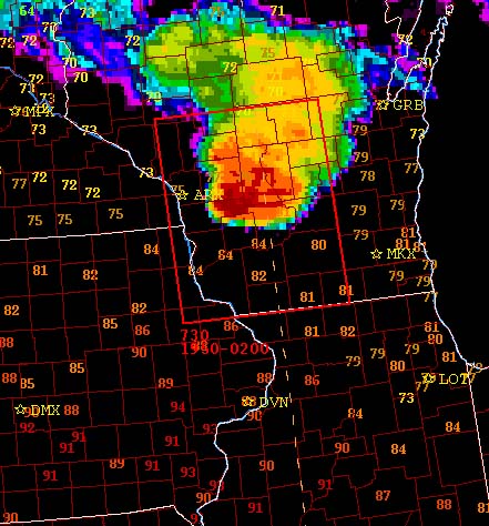
Satellite image of the storms...
MAJOR TORNADO OUTBREAK UNDERWAY TONIGHT...
WISCONSIN HAS BEEN HIT VERY HARD. HUNDREDS OF HOMES DAMAGED OR DESTROYED BY SEVERAL LARGE TORNADOES. REPORTS OF MAJOR DAMAGE IN A NUMBER OF TOWNS.
SPC REPORTING 27+ TORNADOES ON THE STORM EVENT PAGE.
TURN THE PAGE -
CLICK HERE