
MORNING THUNDERSTORMS - MIDNIGHT LIGHTNING - OUT MY BACK DOOR
JUNE 2005 - TROPICAL STORM ARLENE
Spring Storms Have Arrived...
After a quiet May, we now are starting to get thunderstorms. Several
severe storms moved through the Paducah Region overnight. I took this
photograph, out my back door, around midnight this morning!
MORNING THUNDERSTORMS - MIDNIGHT LIGHTNING - OUT MY
BACK DOOR
Thursday...
TROPICAL STORM ARLENE FORMS IN THE GULF OF MEXICO AND CARIBBEAN
This morning, the National Hurricane Center upgraded TD1 to Tropical Storm Arlene. At 8 am, Arlene had maximum sustained winds of 40 mph, was centered at 19.1N 84.0W, and was heading north at 8 mph. As the day wears on, Arlene will likely develop a westerly component to its track even as its forward motion accelerates.
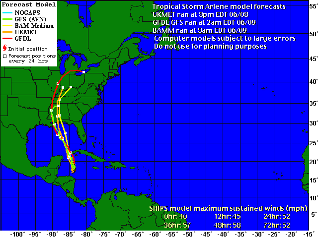
CURRENT FORECASTS BRING ARLENE TO THIS REGION.
Lots of time to watch it.
ARLENE FORMS IN THE ATLANTIC -
CIRCULATION IN THE CARIBBEAN. SLOW DEVELOPMENT LIKELY
OVER THE NEXT 48 HOURS. ARLENE SHOULD BECOME A TROPICAL STORM IN THE GULF
OF MEXICO.
Ok I HATE SPIDERS
We found this black widow this morning!
This is the second black widow I have ever seen in my life. This is defin
the largest one. Needless to say Orkin is coming over to help with this.
GOOD MORNING :( EEEEKKKKKKKKKKKKKKKKKKKKK
WARNING THESE PHOTOGRAPHS BELOW ARE NOT FOR THE FAINT OF HEART
SCROLL DOWN

GOOD MORNING - THIS WAS BY MY FRONT DOOR - UNDERNEATH A WICKER BOX


FRIDAY, JUNE 10, 2005
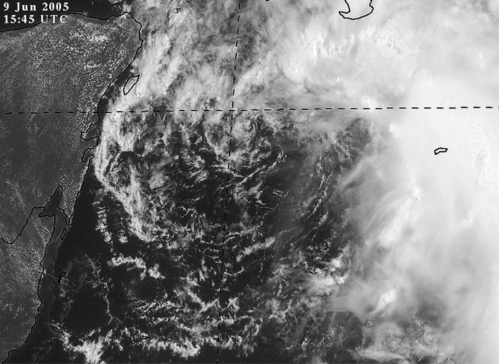
TROPICAL STORM ARLENE GAINS STRENGTH IN THE GULF OF MEXICO
TROPICAL STORM ARLENE INTERMEDIATE ADVISORY NUMBER 8A
NWS TPC/NATIONAL HURRICANE CENTER MIAMI FL
8 AM EDT FRI JUN 10 2005
...ARLENE EMERGING INTO THE SOUTHEASTERN GULF OF MEXICO...
AT 8 AM EDT...1200Z...THE POORLY-DEFINED CENTER OF TROPICAL STORM
ARLENE WAS LOCATED NEAR LATITUDE 22.6 NORTH...LONGITUDE 84.8
WEST...ABOUT 50 MILES...80 KM...NORTH OF THE WESTERN TIP OF CUBA.
ARLENE IS NOW MOVING TOWARD THE NORTH-NORTHWEST NEAR 10 MPH
...16 KM/HR...AND THIS GENERAL MOTION IS EXPECTED TO CONTINUE WITH
AN INCREASE IN FORWARD SPEED DURING THE NEXT 24 HOURS. ON THIS
TRACK...ARLENE WILL BE MOVING AWAY FROM WESTERN CUBA THIS
MORNING...AND WILL BE MOVING ACROSS THE SOUTHEASTERN GULF OF MEXICO
TODAY AND TONIGHT.
REPORTS FROM AN AIR FORCE RESERVE HURRICANE HUNTER AIRCRAFT INDICATE
THAT MAXIMUM SUSTAINED WINDS HAVE INCREASED TO NEAR 55 MPH... 90
KM/HR...WITH HIGHER GUSTS. THESE WINDS ARE CONFINED TO A SMALL
AREA TO THE NORTHEAST OF THE CENTER. SOME ADDITIONAL STRENGTHENING
IS STILL POSSIBLE DURING THE NEXT 24 HOURS.
--------------------
ARLENE WILL LIKELY MOVE INTO MISSISSIPPI AND ALABAMA LATER THIS WEEKEND AND INTO MONDAY. VERY HEAVY RAINFALL WILL BE LIKELY ON THE EASTERN SIDE OF THIS TROPICAL STORM. RAINFALL TOTALS IN EXCESS OF FIVE INCHES WILL BE LIKELY. THE PADUCAH AREA SHOULD SEE SOME RAIN FROM THIS SYSTEM. THE HEAVIEST RAIN IS CURRENTLY FORECAST TO REMAIN EAST OF PADUCAH AND METROPOLIS.
ARLENE CHURNS INTO THE GULF OF MEXICO - SLOWLY GAINING
STRENGTH THIS MORNING.
WINDS ARE NOW UP TO 55 MILES PER HOUR.
I am expecting 21 named storms this season! I know that is a lot but it should be an extremely active season. I wouldn't be surprised to see tropical weather into VERY late fall season (yes that means December!)
This could be the year of the hurricane. Water temps will likely remain above normal this summer and conditions will be very favorable for significant hurricanes. Almost all hurricanes forecasts indicate above normal activity although I believe most are underdone.
Probability of 1 category 5 hurricane - 90%
Probability of 2-3 category 5 hurricane - 80%
Probability of 4 category 5 hurricane - 40%
Probability of 7 major hurricanes - 70%
Probability of 5 or more US Landfalls - 90%
Probability of 6 or more US Landfalls - 80%
Probability of 7 ore more US Landfalls - 60%
Probability of 8 or more US Landfalls - 40%
Probability of less than 4 Storms and or hurricanes hitting the United States -
less than 20%
Probability of 3 or more Major hurricanes hitting the United States - 60%
Probability of 2 or more Major hurricanes hitting the United States - 80%
Probability of 1 Major hurricane hitting the United States - 90%
Prime target this season will be the Gulf Coast
States and the Southeast United States. Florida stands a significant
chance of being hit by multiple storms and hurricanes.
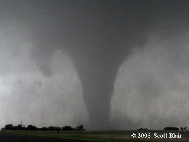
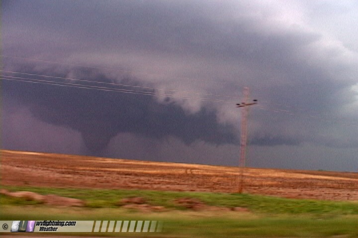
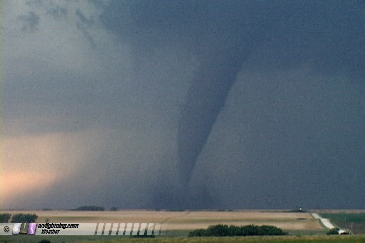
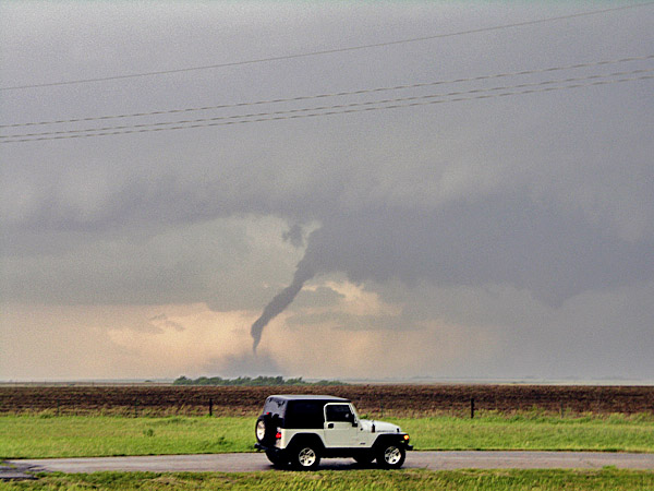
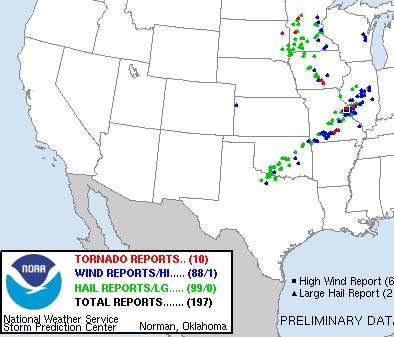
JUNE CONTINUES TO BRING SEVERE WEATHER TO MUCH OF THE UNITED STATES. THOUSANDS OF REPORTS OF SEVERE STORMS HAVE BEEN RECORDED OVER THE PAST 7 DAYS. NUMEROUS TORNADOES HIT THE PLAINS YESTERDAY. MORE THAN 50 TORNADOES WERE REPORTED.
SEVERE THUNDERSTORMS RAKED THE CENTRAL UNITED STATES ON THURSDAY (THIS HAS BEEN THE SAME STORY ALL WEEK LONG)
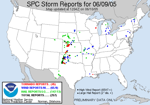
45 TORNADOES WERE REPORTED ON
THURSDAY
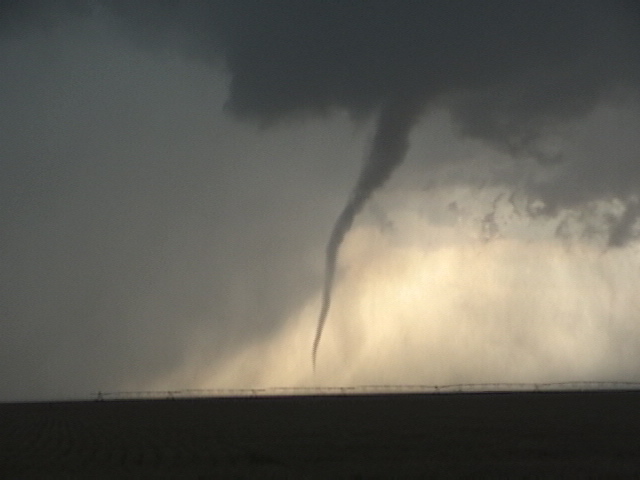
HERE ARE A FEW PHOTOGRAPHS FROM STORM CHASERS
SCOTT BLAIR CAUGHT THIS TORNADO IN KANSAS

11 a.m. TROPICAL STORM UPDATE
ARLENE BEGINS TO STRENGTHEN - MAY BECOME A
HURRICANE BEFORE LANDFALL...
at 11 am...1500
UTC...a Tropical Storm Warning has been issued for
the northern coast of the Gulf of Mexico from Grand Isle Louisiana
to St Marks Florida...including Lake Pontchartrain. Also at 11 am
...A Hurricane Watch has been issued from the mouth of the Pearl
River to Panama City Florida. A Tropical Storm Warning means that
tropical storm conditions are expected within the warning area
within the next 24 hours. A Hurricane Watch means that hurricane
conditions are possible within the watch area...generally within 36
hours.
-----------------------
TROPICAL STORM ARLENE DISCUSSION NUMBER 9
NWS TPC/NATIONAL HURRICANE CENTER MIAMI FL
11 AM EDT FRI JUN 10 2005
ARLENE HAS STRENGTHENED WHILE ENTERING THE GULF OF MEXICO. AN AIR
FORCE RESERVE HURRICANE HUNTER AIRCRAFT REPORTED A MAXIMUM 850 MB
FLIGHT LEVEL WIND OF 64 KT ABOUT 110 NM NORTHEAST OF THE CENTER AT
1130Z. THIS CORRESPONDS TO ABOUT 50 KT AT THE SURFACE...WHICH IS
THE BASIS FOR THE ADVISORY INTENSITY
---------------------------------------------
FRIDAY NIGHT - 8 PM - ARLENE NEARING HURRICANE
STRENGTH - ARLENE COULD BECOME A HURRICANE DURING THE NEXT 12-18 HOURS
8 PM UPDATE FROM THE HURRICANE CENTER...
RECENT DATA FROM A NOAA HURRICANE HUNTER AIRCRAFT
INDICATE THAT
MAXIMUM SUSTAINED WINDS HAVE NOW INCREASED TO NEAR 70 MPH...WITH
HIGHER GUSTS...AND THESE WINDS ARE OCCURRING MAINLY TO THE NORTH
AND EAST OF THE CENTER. SOME STRENGTHENING IS FORECAST DURING THE
NEXT 24 HOURS...AND ARLENE COULD BECOME A HURRICANE LATER TONIGHT
OR ON SATURDAY.
LATEST TRACK FORECAST
SEVERE THUNDERSTORMS IN McCRAKEN COUNTY - PADUCAH -
LONE OAK TONIGHT
Strong storms blew up over Western Kentucky this evening. Paducah, NWS, issued a severe thunderstorm warning for my area around 7:30 p.m. We had a wall cloud pass just north of here. Small hail (pea size) along with frequent lightning and heavy rain as well.
Big storm - here is radar
Strong Thunderstorm Over Lone Oak
WALL CLOUD AND FUNNEL CLOUDS MOVES
THROUGH LONE OAK -
ASHCREEK AREA. THANKFULLY IT DIDN'T TOUCH DOWN.
Lone Oak Wall Cloud
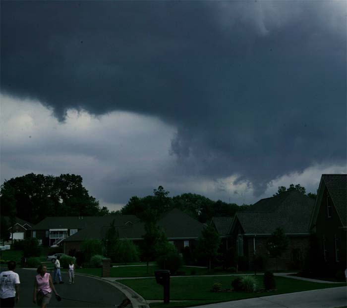
Lone Oak Wall Cloud Passing just north of my house
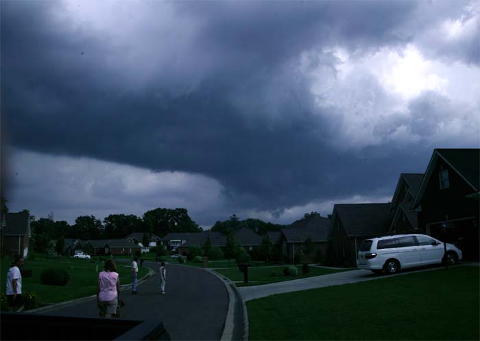
Everyone outside watching the storm as it passes through....Severe Thunderstorm
warning in effect at this time.
RAIN FREE BASE

Rain Free Base
--------------------------------
HURRICANE WARNINGS NOW HAVE BEEN POSTED FOR THE GULF OF MEXICO
DESTIN, FLORIDA IS INCLUDED IN THE HURRICANE WARNING.
At
10 PM CDT...0300z...a Hurricane Warning has been issued for
portions of the north central Gulf Coast from Pascagoula
Mississippi eastward to Destin Florida. A Hurricane Warning means
that hurricane conditions are expected within the warning area...
generally within 24 hours.
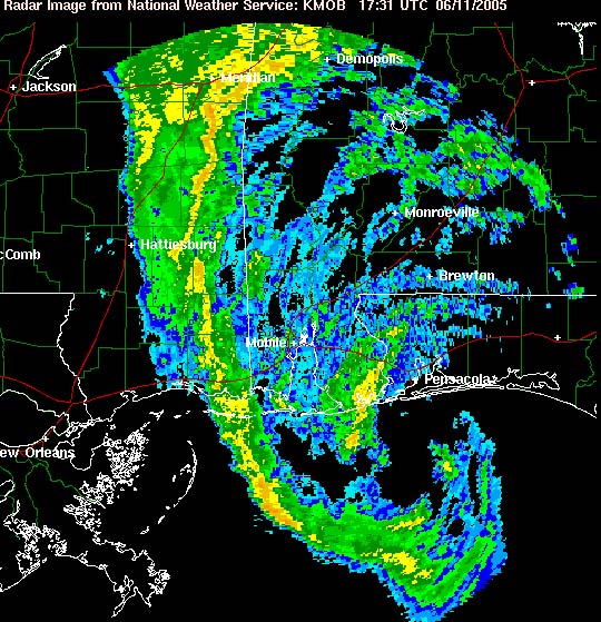
MIDNIGHT RADAR
TROPICAL STORM ARLENE APPROACHES THE GULF
COAST OF THE UNITED STATES.
LATEST FORECASTS BRING THE SYSTEM INTO THIS AREA ON SUNDAY. WE ARE IN A RISK FOR TORNADOES AS THE STORM SYSTEM MOVES THROUGH THE AREA. HIGHEST RISK WILL BE JUST EAST OF PADUCAH.
SATURDAY MORNING - ARLENE MOVING
TOWARDS SHORE
STORMY DAYS AHEAD OF US.
TROPICAL STORM WATCH FOR BIRMINGHAM, ALABAMA.
A HURRICANE WARNING REMAINS IN EFFECT FOR
PORTIONS OF THE NORTH
CENTRAL GULF COAST FROM PASCAGOULA MISSISSIPPI EASTWARD TO DESTIN
FLORIDA. A HURRICANE WARNING MEANS THAT HURRICANE CONDITIONS ARE
EXPECTED WITHIN THE WARNING AREA...GENERALLY WITHIN 24 HOURS.
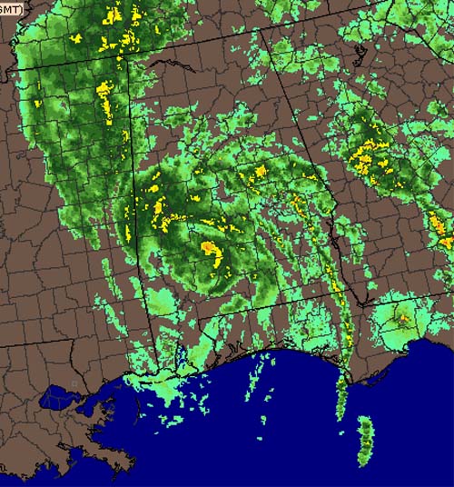
ARLENE IS ALREADY SPREADING TROPICAL MOISTURE INTO WESTERN KENTUCKY AND TENNESSEE. RADAR IS LIGHTING UP THIS MORNING. RAIN IS RAPIDLY DEVELOPING ACROSS THE REGION AND WILL CONTINUE TO DO SO THROUGH THE MORNING HOURS.
TROPICAL STORM ARLENE IS APPROACHING THE FLORIDA PANHANDLE TO THE COAST OF MISSISSIPPI THIS MORNING. SHE IS RIGHT NEAR HURRICANE STRENGTH. TORNADOES WATCHES COVER ALMOST ALL OF FLORIDA. THE THREAD FOR ISOLATED TORNADOES WILL GROW THROUGHOUT THE DAY.
THE STORM PREDICTION CENTER BELIEVES THAT THE PADUCAH AREA WILL SEE THE THREAT FOR TORNADOES ON SUNDAY AS ARLENE MOVES ACROSS THIS REGION.
ANOTHER OUTBREAK OF SEVERE THUNDERSTORMS WILL COME ON MONDAY AS A COLD FRONT SWEEPS THROUGH THIS REGION. THIS COULD BE A SIGNIFICANT EVENT FOR SOME LOCATIONS.
THE 4 a.m. POSITION OF ARLENE
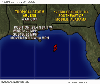
AT 4 A.M. ARLENE WAS NEARING THE COAST
ARLENE SHOULD MOVE ASHORE NEAR MOBILE, ALABAMA LATER TODAY. THIS WILL BRING FLOODING RAINS TO MUCH OF THE SOUTHERN UNITED STATES AND INTO THE TENNESSEE AND OHIO VALLEY. SOME AREAS NEAR NASHVILLE COULD SEE 2-5 INCHES OF RAINFALL. THE HEAVIEST RAIN SHOULD BE JUST EAST OF PADUCAH, HOWEVER, VERY HEAVY RAIN IS LIKELY ACROSS MOST OF WESTERN KENTUCKY AND SOUTHERN ILLINOIS. SOME FLOODING IS LIKELY. TORNADOES ARE ALSO POSSIBLE ON SUNDAY AND MONDAY.
-----------------------
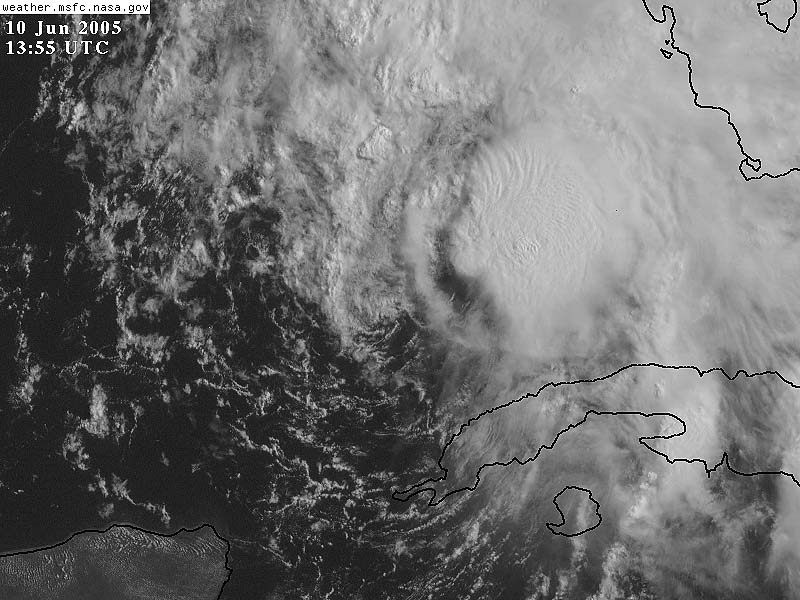
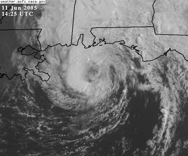
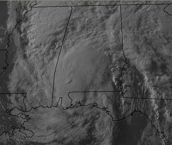
SIX A.M. EYE IS FORMING ON ARLENE AS SHE APPROACHES THE COASTLINE.
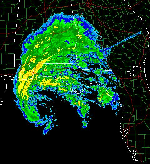
ARLENE IS FORMING AN EYE. YOU CAN SEE THE BROAD
CIRCULATION ON THIS NORTHWEST FLORIDA RADAR.
10 a.m. Saturday Morning
ARLENE IN THE GULF - YOU CAN SEE THE EYE OF THE STORM ON THIS SATELLITE PHOTOGRAPH
AP NEWS PHOTOGRAPH
Don Sheldon makes his daily walk along the beach near
Hollywood, Fla., as Tropical Storm Arlene strengthens
Friday, June 10, 2005. Sheldon said he has not seen such
beach conditions since last year's hurricane season.
(AP Photo/J. Pat Carter)

Cubans stand in the rain as they wait for
transportation in Havana June 9, 2005. The first tropical storm of the 2005
Atlantic hurricane season formed in the Caribbean on Thursday and headed toward
the Gulf of Mexico, bringing heavy rain to Central America, the Cayman Islands
and parts of Cuba. Tropical Storm Arlene was about 115 miles south-southeast of
the western tip of Cuba at 5 p.m. EDT (2100 GMT). Cuba issued tropical storm
warnings from Pinar del Rio to the capital Havana. Arlene's current track could
take it ashore in the United States near the Mississippi-Alabama border late on
Saturday, the National Hurricane Center in Miami said. REUTERS/Claudia Daut
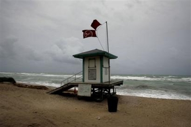
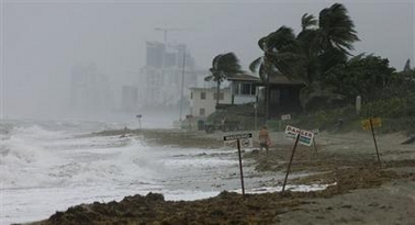
The beach at Hallande, Fla. was closed Friday, June 10, 2005 as Tropical Storm
Arlene grows stronger after drenching Cuba and heading northward towards the
U.S. Gulf Coast. The red flags warning swimmers to stay out of the water flew
above the closed life guard station. (AP Photo/J. Pat Carter)

Richard Knabb, a hurricane specialist at the National Hurricane Center in Miami,
studies the satellite images of Tropical Storm Arlene Friday, June 10, 2005 as
it moves northward in the Gulf of Mexico. (AP Photo/J. Pat Carter)

Lowes store employee Kenny Brown, left, loads plywood into a pickup truck for
Van Carpenter, right, at the Pascagoula, Miss., store, Friday afternoon June 10,
2005. Carpenter said he had recently moved to Hurley, Miss., and he had left his
plywood behind in the move so he was stocking up for Tropical Storm Arlene.
Carpenter.
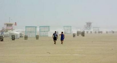
Tourists walk under heavy rain during a tropical storm in South Beach Miami,
Florida, June 10, 2005. The first tropical storm of the 2005 Atlantic hurricane
season, Arlene, skipped over western Cuba and entered the Gulf of Mexico.
REUTERS/Carlos Barria
------------------------------
Gulf Shores, Alabama residents are taking shelter in Red Cross Shelters. I don't think the storm is going to be that bad in most areas. Areas that flood easily could have some difficult times.
ARLENE NEARS THE SHORE - NOON SATURDAY
ARLENE IS NEARING THE COAST OF FLORIDA AND
ALABAMA. SHE WILL COME ASHORE AS A TROPICAL
STORM.

Hurricane specialist Richard Knabb, left, and Lixion
Avila work on an advisory for Tropical Storm Arlene Saturday, June 11, 2005 at
the National Hurricane Center in Miami. (AP Photo/Wilfredo Lee)

5 P.M.
ARLENE MOVES TOWARDS KENTUCKY AND
TENNESSEE
ARLENE MOVES ASHORE - FLORIDA PANHANDLE AND SOUTHERN ALABAMA. HEAVY RAINFALL AND THE THREAT FOR TORNADOES WILL EXIST THROUGH TONIGHT ACROSS THE SOUTH. THIS AREA WILL MOVE INTO TENNESSEE AND KENTUCKY ON SUNDAY.
A FLOOD WATCH IN EFFECT FOR PADUCAH THROUGH THE DAY ON SUNDAY. RAINFALL TOTALS OF 1-3 INCHES WILL BE POSSIBLE. ISOLATED TORNADOES ARE ALSO PREDICTED.
ARLENE MOISTURE ALREADY MOVING INTO WESTERN KENTUCKY TONIGHT
HERE SHE COMES
LAST VISIBLE SHOT OF ARLENE AS SHE MOVES TOWARDS MY
AREA
WEATHERTAP IMAGE OF ARLENE AS SHE MOVES
NORTH/NORTHWEST INTO THIS REGION.
AP PHOTOGRAPHS OF ARLENE - AFTERNOON AND EVENING
PHOTOS:

Don Sheldon makes his daily walk along the beach near
Hollywood, Fla.,
as Tropical Storm Arlene strenghtens Friday. (AP/J. Pat Carter)

GULF SHORES, ALABAMA
Huge waves from Tropical Storm Arlene come ashore at
Gulf Shores, Ala. Saturday June 11, 2005.
People seemed to be enjoying the effects of Tropical Storm Arlene.
Arlene is expected to make landfall near the
Alabama Florida lines. (AP Photo/Bill Haber)
BEAUTIFUL SUNSET IN PADUCAH TONIGHT!
JUST WOW!

DOESN'T GET MUCH BETTER THAN THIS!

THE SATURDAY NIGHT SUNSET - WESTERN
KENTUCKY!
SUNDAY MORNING
Rain began in Paducah around 10 p.m. last night. Arlene is centered southwest of Birmingham, Alabama at midnight.
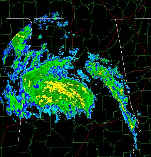
MIDNIGHT SUNDAY MORNING - June 12th, 2005
SUNDAY 10 a.m.
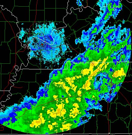
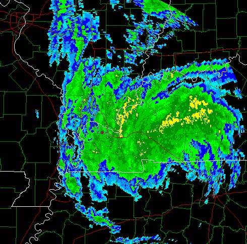
The remenants of Arlene are now located over Western Tennessee. They continue to move towards the north and northwest at about 20 miles per hour. Rain continues in Paducah. Moderate to heavy rain should continue through the rest of today. Rainfall amounts in Paducah should be around 1-2 inches. Tornado threat should remain east of the Paducah Region.
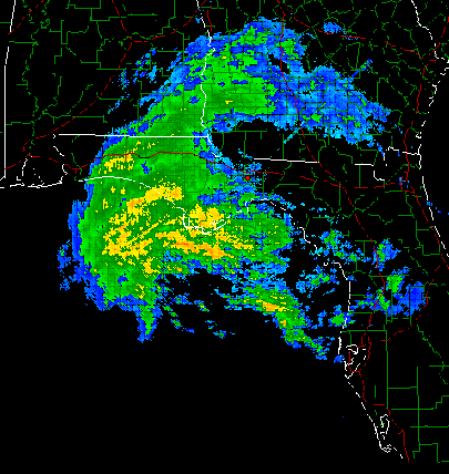
Radar at 10 a.m. shows the circulation over Tennessee
10 a.m. Paducah, Kentucky, NWS Radar
DAY ONE...TODAY AND TONIGHT
A FLOOD WATCH IS IN EFFECT INTO THIS EVENING FOR SOUTHWEST INDIANA
AND MOST OF WESTERN KENTUCKY. WIDESPREAD SHOWERS AND SCATTERED
THUNDERSTORMS WILL CONTINUE ACROSS THE QUAD STATE TODAY...AND ACROSS
THE EASTERN HALF OF THE REGION TONIGHT. HEAVY RAINS WILL BE POSSIBLE
ACROSS THE WATCH AREA INTO THIS EVENING.
DAYS TWO THROUGH SEVEN...MONDAY THROUGH SATURDAY
THERE IS A SLIGHT RISK OF SEVERE THUNDERSTORMS ACROSS THE QUAD STATE
REGION MAINLY LATE MONDAY INTO MONDAY NIGHT...THEN AGAIN ON TUESDAY
INTO TUESDAY NIGHT. THE PRIMARY CONCERNS WILL BE LARGE HAIL AND
DAMAGING WINDS. THUNDERSTORMS WILL END AS A COLD FRONT MOVES OUT OF
THE AREA LATE TUESDAY NIGHT.
-----------------------
NOON SUNDAY
Paducah has already received 1.50 inches of rain - as of noon. This makes over FOUR inches for the week (the last FOUR days)! Amazing amount of rainfall. We were VERY dry. We are now wet!
ARLENE SPINS THROUGH PADUCAH - WESTERN KENTUCKY
NOON-3 p.m. Lone Oak received 0.62" of rain = total rainfall now 2.13"
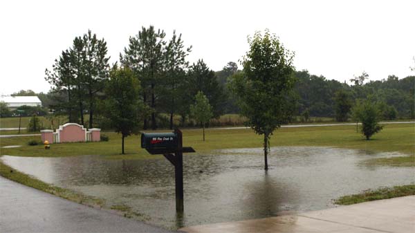
Soaking rain in Lone Oak, Kentucky

ARLENE BRINGS HEAVY RAIN TO LONE OAK - CREEKS NEAR BANKFULL
IN SOME AREAS
PUBLIC ADVISORY NUMBER 17 FOR TROPICAL DEPRESSION
ARLENE
NWS...HYDROMETEOROLOGICAL PREDICTION CENTER...CAMP SPRINGS MD
10 AM CDT SUN JUN 12 2005
...TROPICAL DEPRESSION ARLENE MOVING NORTH ACROSS TENNESSEE...
A FLOOD WATCH REMAINS IN EFFECT ACROSS CENTRAL TENNESSEE...WESTERN
AND CENTRAL KENTUCKY...AND SOUTHERN INDIANA.
AT 10 AM CDT...15Z...THE CENTER OF TROPICAL DEPRESSION ARLENE WAS
LOCATED NEAR 36.1 NORTH....LONGITUDE 87.6 WEST...OR ABOUT 45
MILES WEST OF NASHVILLE TENNESSEE.
ARLENE HAS BEEN MOVING NORTH NEAR 27 MPH OVER THE PAST SIX HOURS
AND THIS MOTION IS EXPECTED TO CONTINUE THROUGH TODAY WITH A
GRADUAL TURN TOWARD THE NORTH-NORTHEAST.
MAXIMUM SUSTAINED WINDS ARE NEAR 25 MPH WITH GUSTS TO NEAR 30 MPH.
MINIMUM CENTRAL PRESSURE IS 29.62 INCHES OR 1003 MB.
SELECTED 24 HOUR RAINFALL TOTALS IN INCHES THROUGH 7 AM
CDT JUNE
12 AND STORM TOTAL RAINFAL FROM 7 AM CDT JUNE 9 THROUGH 7 AM CDT
JUNE 12:
LOCATION
24 HOUR TOTAL
========
=============
COLUMBUS MS
5.16
DOWLING PARK FL
4.81
MOBILE AL
4.39
CRISP COUNTY DAM GA 3.65
PLYMOUTH FL
3.51
TUPELO MS
2.95
MERIDIAN MS
2.83
HURLBERT FIELD FL
2.69
DAYTONA BEACH FL
2.53
TUSCALOOSA AL
2.16
EVERGREEN AL
1.89
ALBANY GA
1.91
JACKSON TN
1.76
MUSCLE SHOALS AL
1.67
JACKSONVILLE FL
1.60
LOCATION
STORM TOTAL
========
===========
NAPLES FL
5.67
HURLBERT FIELD FL
5.42
COLUMBUS MS
5.19
FORT MYERS FL
5.04
MOBILE AL
4.54
HOMESTEAD FL
4.18
WEST KENDALL FL
3.55
MACDILL AFB FL
3.27
TUPELO MS
2.96
MERIDIAN MS
2.89
ADDITIONAL RAINFALL TOTALS SHOULD BE AROUND 2 TO 3 INCHES IN THE
FLOOD WATCH AREAS ALONG THE TRACK OF THE STORM...WITH ISOLATED
HIGHER AMOUNTS. A SECONDARY AREA OF HEAVY RAINFALL COULD ALSO
OCCUR IN THE SOUTHERN APPALACHIANS.
REPEATING THE 10 AM CDT POSITION...36.1 NORTH...87.6 WEST...
MOVEMENT NORTH AT 27 MPH...MAXIMUM SUSTAINED WINDS...
25 MPH...MINIMUM CENTRAL PRESSURE...29.62 INCHES OR 1003 MB.
THE NEXT ADVISORY WILL BE ISSUED BY THE HYDROMETEOROLOGICAL
PREDICTION CENTER AT 4 PM CDT.
LADER
PADUCAH COMMENTS: NWS
Western Kentucky and Southwest Indiana were the primary recipients of a widespread soaking rainfall from 1 to 3 inches. A listing of rainfall measurements from automated rain gage sites is included near the bottom of this page.
The effects of the heavy rain were mostly limited to standing water in yards, and ditches and creeks rose to bankfull in some areas.
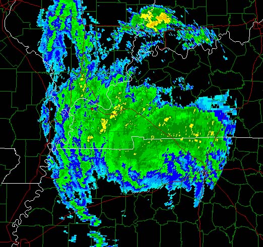
Tropical Depression Arlene: The following image shows the center of dissipating Tropical Depression Arlene over western Kentucky at 1 P.M. on June 12. The surface low position is overlaid on satellite and radar imagery. Most of the rain was in the northern and eastern quadrants of the circulation of Arlene. There were no strong winds from this system over western Kentucky or southwest Indiana. The effects of the depression are contained in an advisory issued by the HPC (Hydrometeorological Prediction Center) at 11 A.M. on June 12.
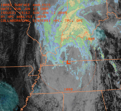
REMNANTS OF ARLENE
Specific rainfall measurements from automated rain gages included:
Evansville, IN... 2.53"
Paducah, KY... 1.53"
Hopkinsville, KY... 1.48"
Uniontown, KY... 3.06"
Benton, KY... 2.48"
Newburgh, IN... 2.46"
Smithland, KY... 2.07"
Barkley Dam, KY... 1.96"
Canton, KY... 1.80"
Cadiz, KY... 1.76"
Greenville, KY... 1.59"
Cobb, KY... 1.26"
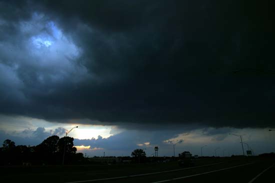
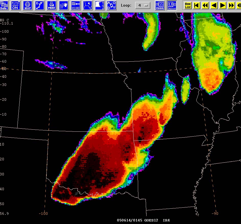
MONDAY - SEVERE THUNDERSTORMS LIKELY ACROSS THE HEARTLAND
SQUALL LINE FORMING TO OUR NORTH AND WEST. SEVERE
WEATHER POSSIBLE
LATER TODAY AND TONIGHT INTO SOUTHEAST MISSOURI AND SOUTHERN ILLINOIS.
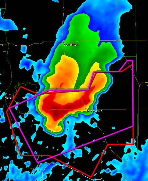
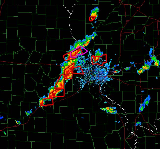
HOOK ECHO NORTH/NORTHEAST OF ST LOUIS - 445 P.M.
TORNADIC SUPERCELL THUNDERSTORM
SATELLITE IMAGE LATE THIS AFTERNOON SHOWS
THUNDERSTORMS BLOWING UP OVER ILLINOIS ALL THE WAY INTO OKLAHOMA.
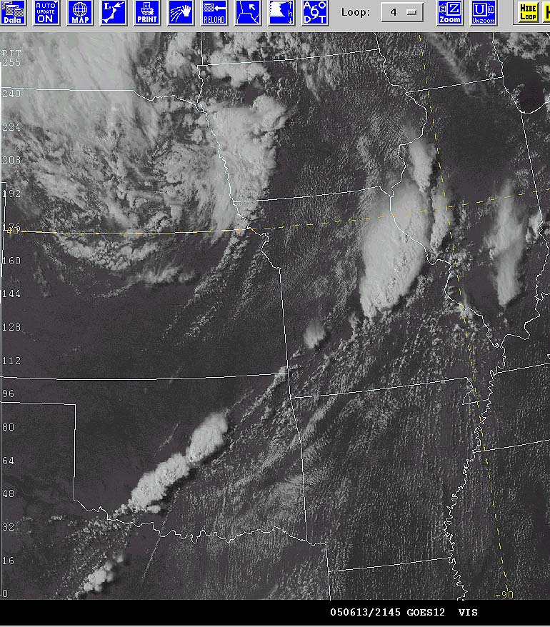
STORMS BLOWING UP OVER MISSOURI AND ILLINOIS. MORE SEVERE STORMS DOWN INTO
OKLAHOMA AND TEXAS. TORNADO AND SEVERE STORM WATCHES ARE IN EFFECT.
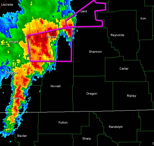
SOUTHWEST MISSOURI - SPRINGFIELD, MISSOURI - TORNADIC SUPERCELL
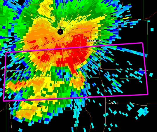
SPRINGFIELD, MISSOURI - TORNADIC STORM MOVING
THROUGH THE CITY
Hook on that cell southeast of Springfield, Missouri
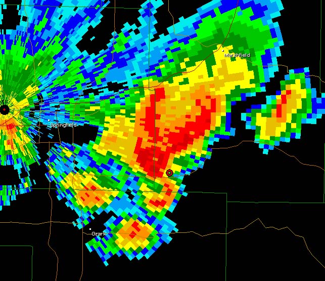
THUNDERSTORM COMPLEX ROLLS THROUGH MISSOURI, OKLAHOMA,
AND ILLINOIS - TORNADOES REPORTED THIS EVENING ACROSS THESE AREAS. 830
P.M. IMAGE
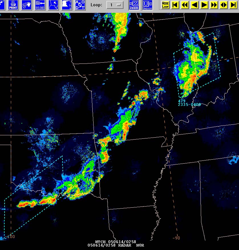
LINE OF THUNDERSTORMS RACING THROUGH SOUTHERN MISSOURI
THIS EVENING. TORNADO WARNINGS CONTINUE TO BE ISSUED WITH THEM AS OF 10
P.M.
SQUALL LINE DUE WEST OF PADUCAH - TORNADO WARNINGS IN
PURPLE. STORMS SHOULD START TO DIE DOWN SOON. HOPEFULLY
WE WON'T GET ANYTHING MAJOR HERE. SOME RAIN FOR SURE.
SEVERE STORMS SO FAR THIS AFTERNOON
AND TONIGHT
Storms passed through here without anything major in the severe weather department. Looks like they will refire now to our east. We did good on this one. People west of here were not so lucky.
Looks like a few nice days ahead of us.
This page is WAY too long :) CLICK HERE TO TURN THE PAGE
See PADUCAH Live View Web-Cam Below
------------------------------------------------------
------------------------------------------------------
LIVE: VIEW
FROM DOWNTOWN PADUCAH
...VIA WEB CAM FROM WPSD NEWS CHANNEL 6

------------------------------------------------------
------------------------------------------------------
MAILING ADDRESS
BEAU DODSON
465 Ashcreek Road
Paducah, Kentucky
42001
Phone Number
Home 270-554-6715
Cell 270-970-1202
Email beaudodson@hotmail.com