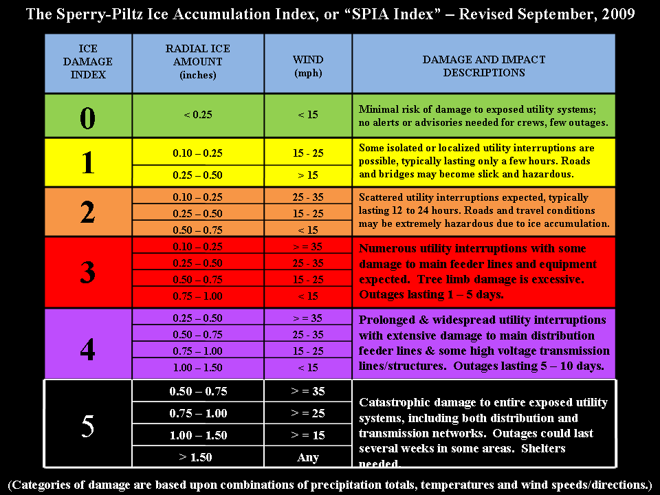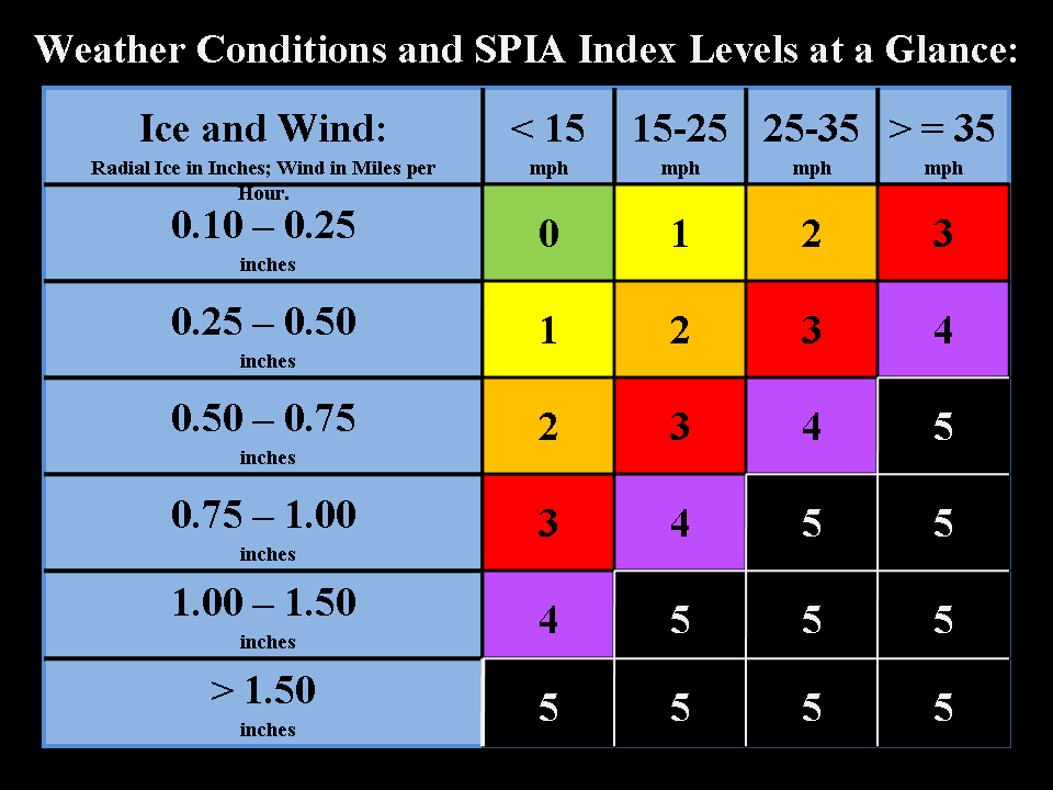

Please keep in mind that the ice storm rating system is highly subjective.
During an ice storm there can be great variations in damage from one
county to the next. A great example of this would be the 2008 and 2009 ice
storm events in our local region. The difference in damage between one
county north or south of Graves County, Kentucky was substantial - to say the
least. Portions of Tennessee had little or no ice. Graves
County, Kentucky (right across the border from west Tennessee) had catastrophic
ice damage.
Freezing drizzle can cause extremely dangerous (life threatening) driving
conditions. This ice storm rating scale is NOT intended to be
used for travel planning purposes or to rate travel conditions. The scale
is only a forecast of POTENTIAL damage to power lines and trees.
Remember that a rating of 0 does not mean that there will not be travel
problems. Air temperatures can also have a major impact on
whether road conditions become hazardous. It is possible to have a
damaging ice storm (to power lines and trees) and for roadways
to remain relatively free of ice. Remember that bridges and overpasses
freeze first.
Please listen to all official forecasts - advisories - watches and warnings that
are issued by the National Weather Service.
Most advisories, watches, and warnings contain a call to action statement.
This call to action statement should advice you of what
type of impacts a winter storm is expected to cause.
For more information on this ice storm damage index please visit the
following web-site: This is a PDF file.
Click here.
Another story on this
index can be
viewed here.
The local National Weather Service Office has chosen NOT to use this scale as
of 2009 (some neighboring offices are using the scale). This
scale is for planning purposes only. Any forecast issued by Beau Dodson is
his and his alone.
Please keep in mind that it only takes a small glaze of ice to cause
significant travel problems.
Ice storms are extremely difficult to forecast - a slight difference in the
track of a storm system can cause dramatic changes in forecasted precipitation
amounts and precipitation type. Please listen for updated forecasts before
and during the event.

For those of you who are a Cocorahs Observer:
So, How do I measure ice?
Freezing rain is precipitation that reaches the ground in liquid
form and then freezes on contact. The deposits of ice are called glaze. Glaze is
not snow or
sleet. If you receive freezing rain only, then you melt what lands in your gauge
and report that as your daily precipitation amount. You report the new snow
amount to be 0.0 However, the entry for "Total Depth of Snow" includes the depth
of both snow (new and old) AND ice. So if the glaze has accumulated to a
depth of about 1/2 inch, you report 0.0 for your snowfall but 0.5 as your total
depth of snow (and ice) on the ground.
Freezing rain can make it nearly impossible to remove your gauge
from its mounting bracket for melting and measuring. If freezing rain is
anticipated, it
may be a good idea to remove the gauge from its' bracket and set it securely on
the ground. Warm water can be used to melt the ice on the bracket
to free the gauge, if necessary.
There is no perfect fast way to melt the ice inside and along the rim of your
gauge. You only want the ice that has accumulated inside the beveled rim of
your gauge to end up in your measurement for the day. Bring the gauge inside and
let the ice melt. Adding a measured amount of warm water to
the inside of the gauge can hasten the melt, if necessary. Use of microwaves to
melt the ice inside the gauge is not recommended as we do not
know who well these gauges hold up to microwaves.
If you can afford it, winter is the time to splurge and get a
second gauge. You can order extra outer cylinders from the company that makes
them up in
Minnesota. There is a parts list inside your rain gauge box. It is really great
to be able to bring in one gauge and set out another so you don't have to rush
melting and measuring the precipitation. I've heard from a few of you, that
you've collected three or even four gauges to make winter measurements,
including
core sample measurements, quicker and easier.
In the event of freezing rain, there is a very useful measurement that you can
make. All you need are your eyes and a simple ruler. Engineers for utility
companies, power transmission lines, communications towers, etc need to be able
to compute the weight of ice buildup so they can better design and build
structures to withstand heavy ice loads. Using a ruler, measure the RADIAL
THICKNESS of ice that has accumulated on objects above ground. Straight
twigs and fence wires provide good surfaces for radial ice thickness
measurements. The radial thickness is the average thickness of the ice sticking
out in all directions from the center of the collection surface. It is the
RADIUS of that ice that we are interested in, NOT the diameter. Use a
ruler to measure the radial thickness to the nearest 1/8 or 1/10th inch. Report
that information along with any other useful remarks in your "Observation Notes"
The above information was copied from this link: Click here
More information on measuring snow and ice: Click here