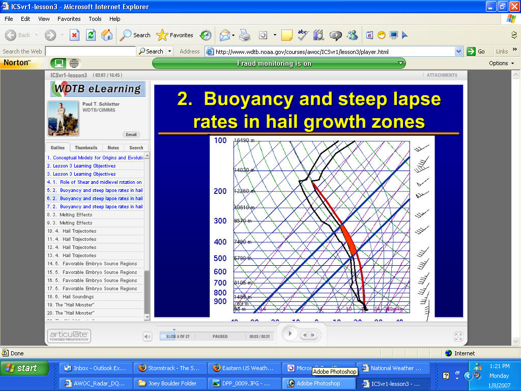
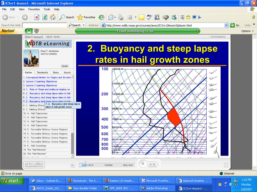
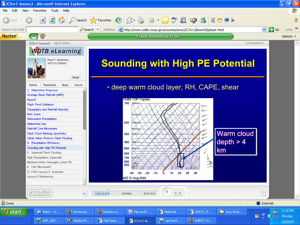
Hail Threat on Soundings
Follow the blue line...temps to -10 and -20 or -30 and see how much cape is
in that region
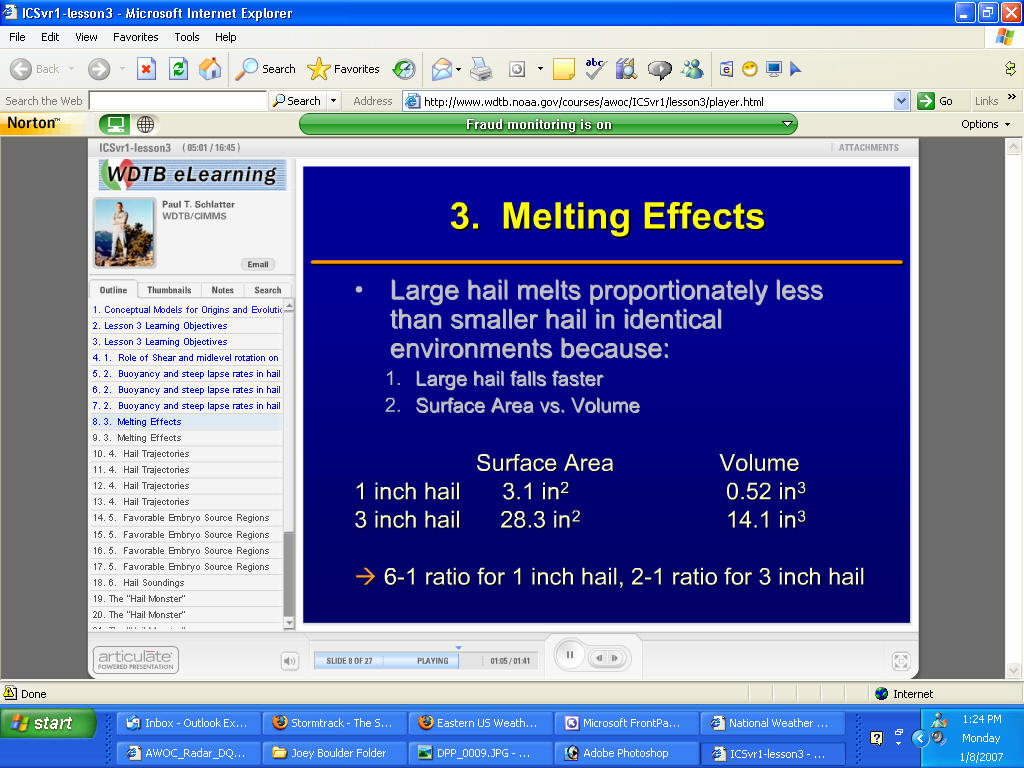
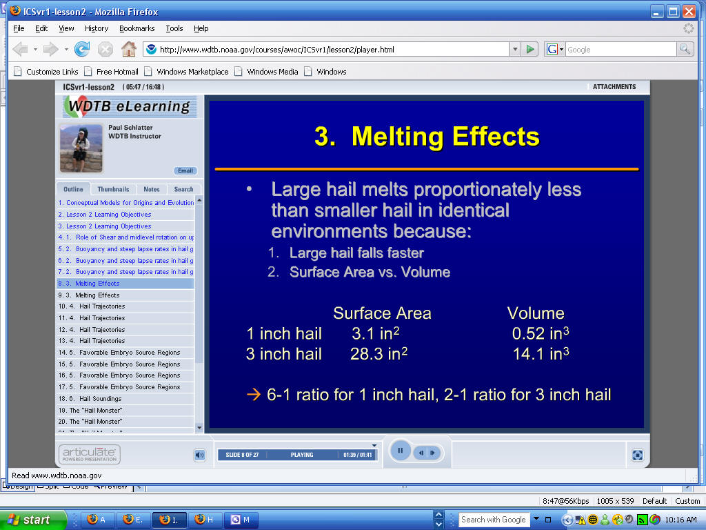
Longer the residence time in a storm the larger the hail
Large hail melts less because it has a higher fall velocity
Look for the -10 to -30C Area...high cape in those areas and steep lapse
rates will mean a large hail threat is much more likely/
See below soundings
Thin CAPE in that zone...no hail reported on this day
METEOROLOGIST JEFF HABY
Hail is both destructive to vegetation and manmade structures. Hail is
classified as severe by the National Weather Service if it is equal to or
greater than 3/4" in diameter. Strong winds make these darting spheres of ice
even more damaging. It is difficult to pin point where exactly a large hail
shaft will strike just as it is difficult to predict where tornadoes will
exactly occur. However, the general region where hail can be expected is very
predictable. Hail occurs in association with thunderstorms, particularly
supercell thunderstorms. Below are factors to consider when trying to forecast
for the likeliness and size of hail.
1. ELEVATION:
Higher elevation areas are closer to the cold layers of the upper atmosphere.
When a hail stone falls, it rapidly begins to melt when the environmental
temperature rises above freezing. If the hailstone has to fall through a deep
layer of warm air, it will melt from the outside in, turning into non-damaging
raindrops or decreasing significantly in size. Mountainous regions and the High
Plains of the United States have the highest number of hail days per year. Small
hail which would normally melt before reaching the surface in a low elevation
area reaches the surface in high elevation area. Storms do not need to be as
severe in the lee of the Rockies as in lower elevation areas for hail to reach
the surface.
2. FREEZING LEVEL:
The freezing level determines the depth of the atmosphere that is above
freezing. If the freezing level is high in the atmosphere, hailstones will have
more time to melt than if the freezing level is close to the surface. A high
freezing level also decreases the vertical depth in which hailstone formation
and growth is possible. The freezing level depends on elevation, the season, and
the temperature profile of the atmosphere. High elevation areas will have
relatively low freezing levels in all seasons. For low elevation areas a general
rule to follow is: If the freezing level is closer to the surface than 650
millibars, strong thunderstorms have a good probability of producing hail that
will reach the surface. The freezing level can be found readily by examining the
morning or afternoon Skew-T Log-P plot or forecast sounding.
3. WET BULB ZERO LEVEL:
The wet bulb zero level is defined as the freezing level that will result due to
evaporational cooling. The freezing level will lower if there is dry air in the
mid-levels of the atmosphere. This occurs due to evaporational cooling of
environmental air that entrains into a thunderstorm. This same entrainment can
also produce strong and gusty surface winds. Dry mid-levels are common in the
Great Plains. This is another factor that leads to many hail days in this region
of the US.
4. CONVECTIVE AVAILABLE POTENTIAL ENERGY (CAPE):
This is the most important factor in determining hail size. CAPES under 1000
J/kg generally produce borderline severe hail (near 3/4" or less) while CAPES
over 2000 J/kg can produce very large hailstones. High CAPES lead to high upward
vertical velocities within a thunderstorm. High UVV's can suspend hailstones and
add layers of ice onto already developed hailstones. The amount of CAPE can be
approximated by modifying the morning Skew-T sounding for that day. In many
cases this is executed by changing the surface temperature and dewpoint to fit
current observations. Forecast model soundings can also be examined for changes
in CAPE during the day.
5. SUPERCELL THUNDERSTORM (HIGH WIND SHEAR):
Strong upper level winds allow CAPE to be maximized to its fullest potential.
Strong upper level winds tilt the updraft of developing thunderstorms. This
allows the updraft and downdraft to be separated from each other. This produces
higher UVV's in the updraft.
6. PRECIPITABLE WATER:
The weight of moisture and water will influence the strength of the updraft.
High moisture soundings result in water loading. CAPE is reduced with water
loading since the force of gravity pushes down on the liquid water drops.
Precipitable water values of less than 1.0" will not be nearly as influenced by
water loading than if precipitable water values are above 1.5". Lower
precipitable water values have the potential to produce large hailstones when
significant CAPE is present. Low precipitation supercells are notorious for
producing large hail. In the lee of the Rockies, PW is climatologically low,
adding to the hail potential.
----- consensus -----
Hailstone size is maximized by high elevation, low freezing levels, low PW,
dry mid-level air, high CAPE, and large wind shear. The region of the country
that these factors come together the most are in the High/Great Plains of the
US.
Hailstone size is minimized by low elevation, high freezing levels, water
loading (high PW), moist mid-levels, low CAPE, and weak wind shear.
Then compare to this one with a lot of CAPE in that area - this produced the
largest hail ever recorded
Large hail melts slower because of two reasons - see below
Higher the humidity the more likely the hail will melt faster...that and
higher temperatures.
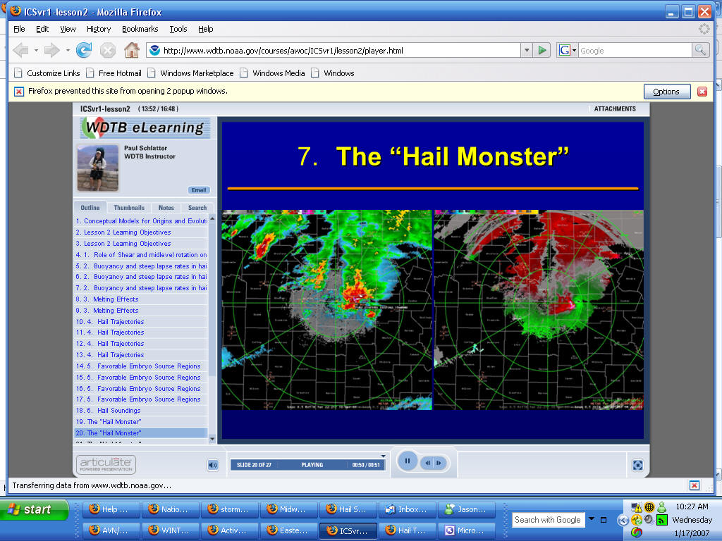
Below images you can see the BWER and the intense hail chore aloft.
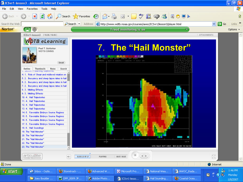
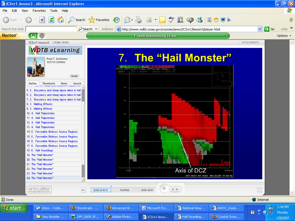
You can see the DCZ - Deep Convergence Zone - this is what you should look
for as far as LARGE hail and hail storms. Cross section image velocity.
 '/
'/
The hail monster...you can see the flanking line and the
strong convergence along that area - good sign that large hail is likely
see below this Missouri Hail Storm Radar Image
WER EXAMPLE weak echo region - that is the updraft
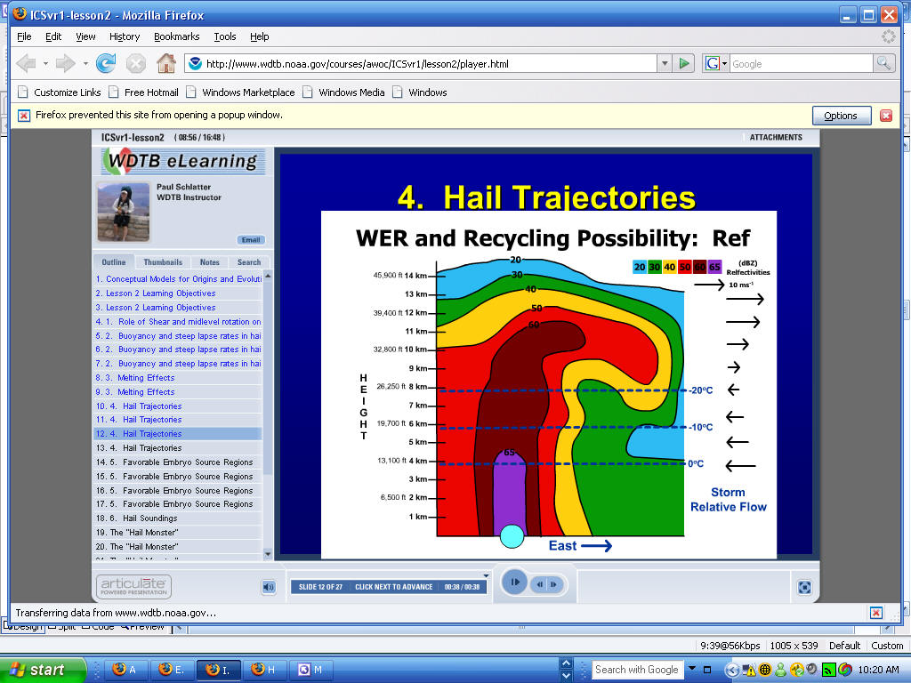
Heavy Rainfall Convergence
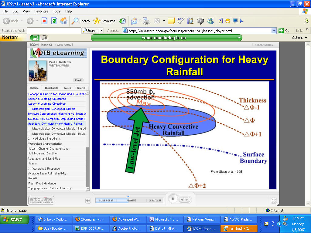
WARM CLOUD LAYER ABOVE THE LCL - above 0C - High CAPE is not good for Heavy
Rainfall nor is HIGH SHEAR - you need some strong Low Level
winds/jet.
|
|
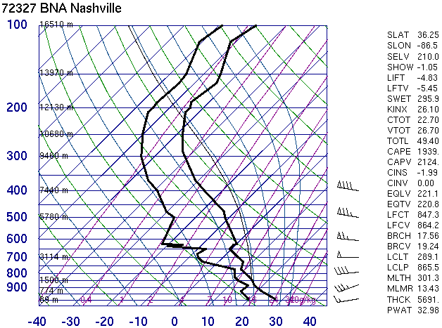
Decent: 819 J/kg, no CIN |
|
|
Excellent: 0-6 km shear of 45 knots, good veering
profile, WSW 95 knots winds at tropopause |
|
Mid-level Lapse Rates:
|
Good: about the same as or better than moist adiabatic up
through at least -30C |
|
Freezing Level:
|
10.6 kft |
Overall Threat of Severe Hail:
|
Moderate: Would like to see more CAPE, but rotational
potential is huge with any storm that gets going. The shear is so good it's
tough to not go moderate risk. |
Summary of the Event:
Date of Sounding: 22 January 1999 @ 00 UTC
This turned out to be a very significant tornado and large hail outbreak
across much of Arkansas. From 20:30-02:00 UTC the LZK office logged 87
severe hail reports, with several reports larger than 3.00 inches (5.00
inch hail was largest). Numerous supercells were to blame for the hail
reports, and the majority of the supercells were tornadic. For this event
it is likely that dynamically induced vertical pressure gradients due to
strong rotation within the storms siginificantly added to the hail threat,
as enormous hail was produced with less than 1000 J/kg CAPE
|
|
|
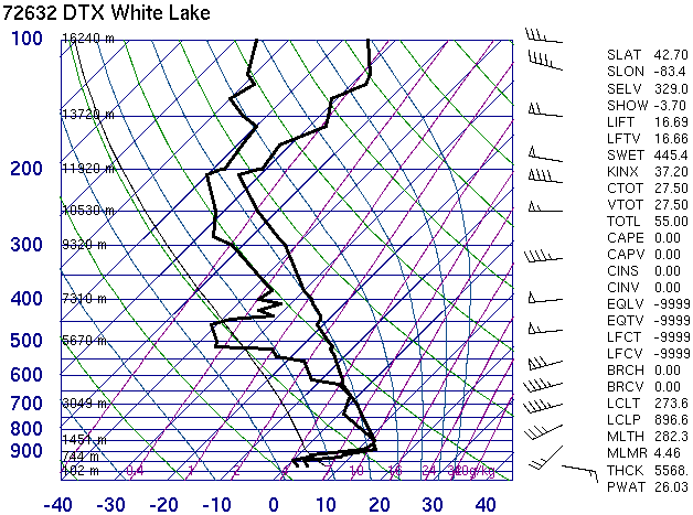
Good: 2124 J/kg makes it almost excellent, no
CIN.
|
|
|
Excellent: 60 knots shear 0-6 km, but unidirectional
|
|
Mid-level Lapse Rates:
|
Excellent: above -10 the lapse rates are nearly dry
adiabatic up to -40 C. |
|
Freezing Level:
|
12.2 kft |
Overall Threat of Severe Hail:
|
High: This is a no brainer. All ingredients are there and
very strong in this sounding |
Summary of the Event:
Date of Sounding: 28 April 2002 @ 18 UTC
Locations in Nashville reported golfball hail at 19 UTC. Additional
supercells developed southwest of Nashville, all producing severe hail,
and 3.00 inch hail was reported at 20:38 UTC 50 miles southwest of
Nashville.
|
|
|
Elevated: Even an elevated parcel yields very little CAPE
|
|
|
Excellent: 0-6 km shear is 60-70 knots, with great
veering near warm front |
|
Mid-level Lapse Rates:
|
Weak: moist adiabatic |
|
Freezing Level:
|
10.6 kft |
Overall Threat of Severe Hail:
|
None: Doesn't appear to be any elevated CAPE potential on
the sounding, and the lapse rates are weak throughout the depth of the
troposphere. Shear is very good however, thus storms get going north of the
front they should rotate. It would be helpful to see the environment south
of the warm front.
|
Summary of the Event:
Date of Sounding: 10 April 2001 @ 00 UTC
It would be a stretch to label the severe hail risk "slight" north of the
warm from without seeing what the atmosphere was doing to the south. There
was elevated CAPE north of the warm front with a source of instability
from the southwest. Rotating storms formed north of the warm front in the
Detroit area (Wayne County), and they were large hail producers, with 3.50
inch hail at just before 15 UTC in Belleville (a picture of some of that
hail is on the center of the banner at the top of the index page). There
were 3 reports of golfballs and over 10 0.75 inch hail reports from this
event, all with mid 40s surface temperatures.
|
see how small hail melts a lot faster...6 to 1
compared to 2 to 1 of 3 inch hail below example
Very warm temp profile and lots of humidity melt
hail faster...you can still have very large hail in those conditions if it is
large hail to begin with.
Instructions:
1. Examine each skew-T plot and
diagnose the threat level of hail (in your head) based on each of
the following parameters that are listed below each sounding:
CAPE of any parcel
Deep layer (0-6 km) shear
Mid Level Lapse Rates
The subjective scale used for rating
the parameters is "weak", "decent", " good", "excellent", and "begin
crying" (a few instances a year that particular parameter is that
high).
2. After diagnosing the hail threat
by parameter, mentally decide on an overall hail threat, using SPC
nomenclature of "none", "slight", "moderate", and "high". Then click
the "Reveal" button to show what and why an experienced hail
forecaster would have assigned each parameter and overall hail
threat. Clicking reveal also displays a brief summary of the hail
event.
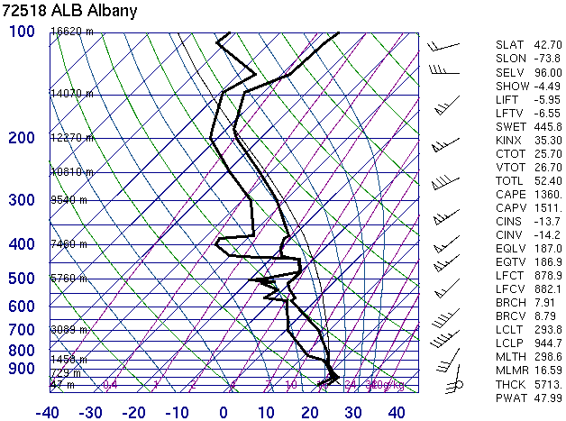
Good: 1511 J/kg just above the very shallow inversion. Not much CIN.
Excellent: If surface ob correct, then 0-6 km shear is 65 knots, with 80 knot
winds at at 10 km. There is some decent veering in the lowest 2 km.
Mid-level Lapse Rates:
Decent: weak above -10 C and there appears to be a cloud layer. Its also moist
adiabatic above -20 C.
Freezing Level:
13.1 kft
Overall Threat of Severe Hail:
Moderate: The CAPE is pretty good and the shear is great, but the mid-level
lapse rates do not look favorable for significant growth within the hail growth
zone, thus just a moderate.
Summary of the Event:
Date of Sounding: 22 July 2003 @ 00 UTC
A squall line associated with an MCV resembling a "land hurricane" moved
across the northeast U.S. It was mainly an embedded tornado and straight
line wind event. Hail reports were surprisingly very scarce, with just one
report from anywhere in PA/NY on the entire day: golfballs not far from
Albany at 00:30 UTC 22 July 2003.
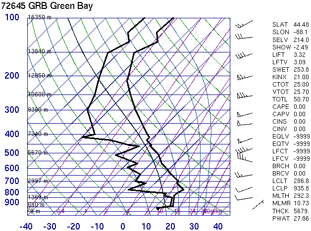
Weak: 379 J/kg, nice low level lapse rates though.
Decent: 0-6 km shear 25-30 knots, but there are 75 knot winds at 10 km.
Mid-level Lapse Rates:
Good: nearly dry adiabatic up until almost -20C
Freezing Level:
15.3 kft
Overall Threat of Severe Hail:
Slight: Not a lot of CAPE or shear, but combined with the lapse rates this
deserves a slight severe hail threat.
Summary of the Event:
Date of Sounding: 27 July 2003 @ 00 UTC
A cluster of severe thunderstorms initiated ahead of an approaching upper
level short wave trough. 2.00 inch hail fell in extreme eastern Oregon at 23
UTC, and 1.00 inch hail at 00:05 UTC in western Idaho. The event as a whole
was described as a "massive outbreak" in E. Oregon and W. Idaho.
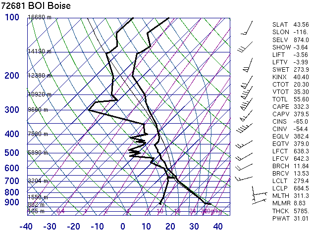
Weak: 466 J/kg, more if the skin layer of moisture is used for a surface parcel
Good: 0-6 km 50 knots shear, but all unidirectional
Mid-level Lapse Rates:
Weak: essentially moist adiabatic from -10 C and above
Freezing Level:
12.1 kft
Overall Threat of Severe Hail:
Slight: Not a lot of CAPE, shear is good but unidirectional, and lapse rates are
weak. It would take a rotating storm to get some severe hail, and that is
certainly possible with this shear.
Summary of the Event:
Date of Sounding: 28 September 1998 @ 00 UTC
At 2040 UTC on the 27th 4.00 inch hail fell at Niagara Falls, NY. The
sounding above was very likely not representative of the environment that
the hailstorms were feeding on. Though very close in proximity to the
hailstorms, the sounding was 3-4 hours after the event.
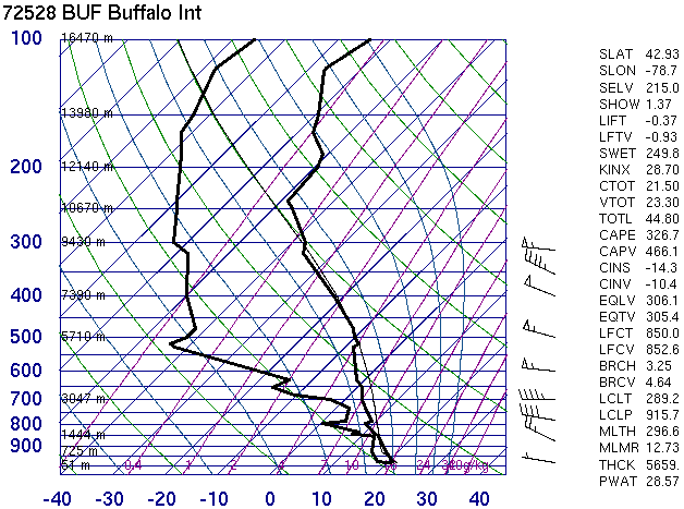
Excellent: No CIN, 3001 J/kg, although it is more of a "thin" CAPE profile
Decent: 0-6 km shear is 30-35 knots with great veering
Mid-level Lapse Rates:
Decent: nearly moist adiabatic in the growth zone
Freezing Level:
12.6 kft
Overall Threat of Severe Hail:
High: The CAPE/shear combination is outstanding. The only thing keeping this
from not great are the lapse rates but the shear/CAPE should more than make up
for that.
Summary of the Event:
Date of Sounding: 16 November 2001 @ 00 UTC
This was mainly a flash flood/tornado event for south Texas. However, one
storm south of the flash flooding and tornadic storms did produce 0.75-1.00
hail 50 miles north of Corpus Christi at 2:00 UTC. It was the only storm of
the day with reported severe hail.
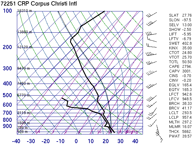
Good: 1765 J/kg, some CIN.
Good: 40 knots 0-6 km shear from 180 degrees of veering 0-3 km.
Mid-level Lapse Rates:
Excellent: steep throughout the growth zone.
Freezing Level:
15.1 kft
Overall Threat of Severe Hail:
Moderate: CAPE is good and there are great mid-level laspe rates. For a high
threat, it's be nice to see a little better shear and higher CAPE.
Summary of the Event:
Date of Sounding: 27 May 2001 @ 00 UTC
A supercell formed overnight in southwest Texas, and struck the KDFX (Del
Rio) radome with 4.00 inch hail and winds to 84 knots. The combined effects
of the enormous hail followed by the wind caused the radome to collapse.
Several goats in the area were killed by the hail.
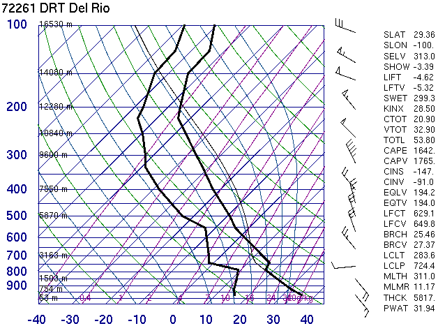
Weak: 441 J/kg
Excellent: 0-6 km shear of 50 knots, 100 knot winds at 10 km, and strong
veering.
Mid-level Lapse Rates:
Weak: moist adiabatic or worse from -5 C and above
Freezing Level:
9.9 kft
Overall Threat of Severe Hail:
Slight: CAPE and mid-level lapse rates as low as this are the reason this is
only slight.
Summary of the Event:
Date of Sounding: 22 November 1996 @ 12 UTC
Although this sounding is on the east side of the Sierras, the wind shear
was very similar in California's Central Valley. CAPE was probably slightly
higher (800-1000 J/kg) in the Central Valley. A supercell produced 2.5 inch
hail in Lemoore at 2250 UTC, as well as few tornadoes.
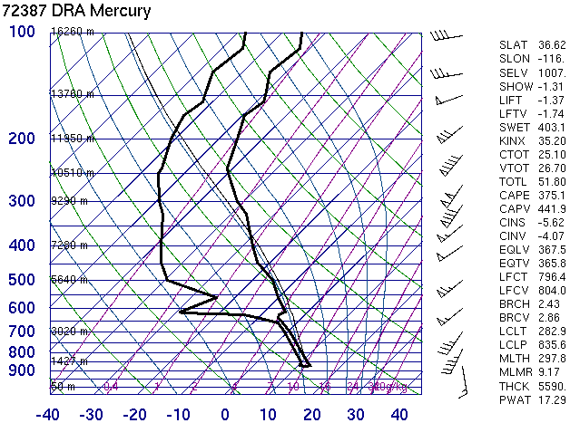
Elevated: Even an elevated parcel yields very little CAPE
Excellent: 0-6 km shear is 60-70 knots, with great veering near warm front
Mid-level Lapse Rates:
Weak: moist adiabatic
Freezing Level:
10.6 kft
Overall Threat of Severe Hail:
None: Doesn't appear to be any elevated CAPE potential on the sounding, and the
lapse rates are weak throughout the depth of the troposphere. Shear is very good
however, thus storms get going north of the front they should rotate. It would
be helpful to see the environment south of the warm front.
Summary of the Event:
Date of Sounding: 10 April 2001 @ 00 UTC
It would be a stretch to label the severe hail risk "slight" north of the
warm from without seeing what the atmosphere was doing to the south. There
was elevated CAPE north of the warm front with a source of instability from
the southwest. Rotating storms formed north of the warm front in the Detroit
area (Wayne County), and they were large hail producers, with 3.50 inch hail
at just before 15 UTC in Belleville (a picture of some of that hail is on
the center of the banner at the top of the index page). There were 3 reports
of golfballs and over 10 0.75 inch hail reports from this event, all with
mid 40s surface temperatures.
Decent: 1315 J/kg, but lots of CIN for surface parcel
Good: 0-6 km shear of 40 knots, with good veering.
Mid-level Lapse Rates:
Good: in between dry and and moist adiabatic
Freezing Level:
14.1 kft
Overall Threat of Severe Hail:
Moderate: Limiting factor is CAPE/CIN combination, would like more CAPE and less
CIN.
Summary of the Event:
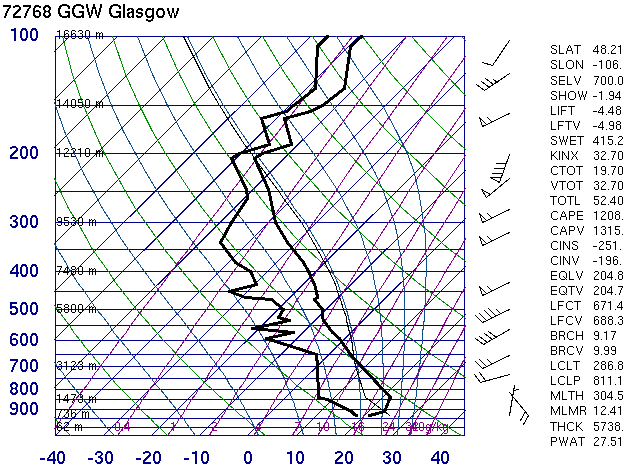
Date of Sounding: 21 July 2001 @ 00 UTC
Monster supercell initiated along a warm front across eastern Montana (south
of this sounding). The supercell produced up to 4.50 inch hail and large
amounts of severe hail all along it's trek across eastern Montana. The
softball hail fell from 23-00 UTC 40-50 miles southeast of Glasgow. Extreme
downburst winds accompanied the storm as well.
Elevated: but pretty good above warm front
Good: 0-6 km shear of 40 knots
Mid-level Lapse Rates:
Excellent: steep from 0 to -20 C, and not too bad above that.
Freezing Level:
13.3 kft
Overall Threat of Severe Hail:
Slight: need to see environment south of the warm front, but the steep lapse
rates above the frontal inversion are impressive.
Summary of the Event:
Date of Sounding: 12 May 2000 @ 12 UTC
Much like the Detroit case, a supercell initiated before noon in western
Wisconsin, north of a warm front. SBCAPE south of the warm front was over
2000 J/kg, but surface temps in Wisconsin were in the low 50s. The supercell
was a hail beast, with very wide swaths of severe hail and several reports
of 2.00 to 2.50 inch hail, between 15-16 UTC and just south of Green Bay.
The shear amounts of the large hail combined with severe winds did
tremendous damage across central and eastern Wisconsin, making it one of the
costliest storms ever to hit Wisconsin.
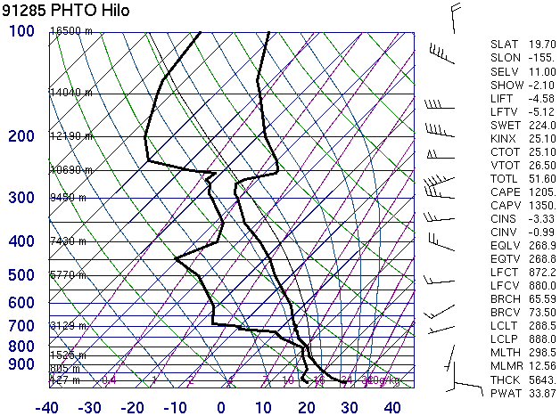
Good: 1350 J/kg, but fairly narrow CAPE profile, no CIN
Weak: 20-25 knots 0-6 km shear because of veering profile, but 60 knot westerly
winds at 11 km is impressive for the tropics
Mid-level Lapse Rates:
Decent: Moist adiabatic from +10 C and above
Freezing Level:
12.0 kft
Overall Threat of Severe Hail:
Slight: Unusual to have a thermodynamic profile in the tropics like this.
Because of the CAPE profile and decent lapse rates in the growth, severe hail is
a possibility even in Hawaii.
Summary of the Event:
Date of Sounding: 26 January 2004 @ 00 UTC
Storms formed all across Hawaii on the afternoon of the 25th. An F0 tornado
was photographed on Oahu at 23:45 UTC. On the big island, there was one
report of 0.75 inch hail, occurring at 1:15 UTC in Hilo (not a bad proximity
sounding). This proves the point that if the right atmospheric conditions
are in place, severe hail can occur anywhere in the U.S.
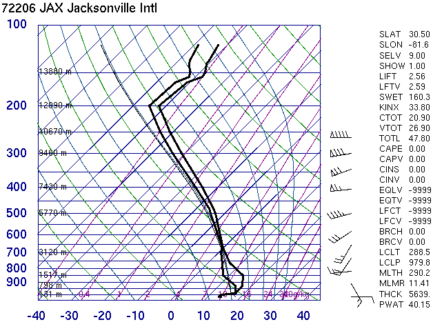
#12 Jacksonville, Florida
Elevated: The dry adiabatic lapse rates between 950 and 850 mb could lead to
decent CAPE.
Good: 40-50 knots 0-6 km shear, with great veering and 90 knot westerlies at
10.5 km.
Mid-level Lapse Rates:
Weak: saturated environment, thus a contaminated sounding
Freezing Level:
11.4 kft
Overall Threat of Severe Hail:
Slight: looks pretty tropical, but shear is good enough that storms that go
along the warm front should be able to produce some severe hail
Summary of the Event:
Date of Sounding: 1 March 2003 @ 12 UTC
Jacksonville was just north of a warm front across northern Florida. SBCAPE
just south of the warm front was around 1000 J/kg. A severe storm formed on
the warm front about 20 miles southwest of Jacksonville. In Hampton,
softball hail fell at 14 UTC, and there were several other reports of 0.75
inch to golfball hail across northeast Florida.
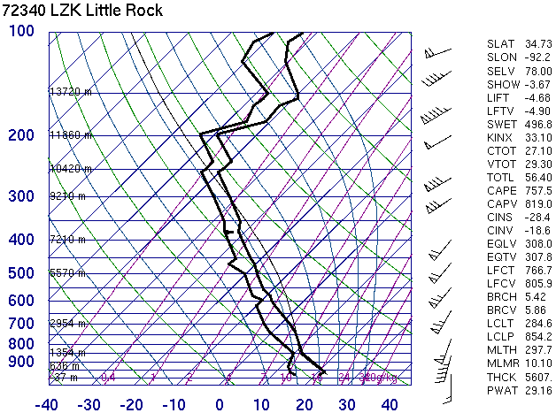
#13 Little Rock, Arkansas
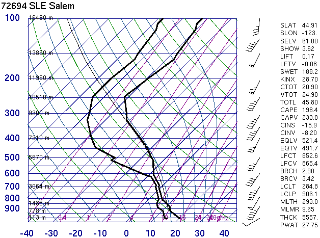
Decent: 819 J/kg, no CIN
Excellent: 0-6 km shear of 45 knots, good veering profile, WSW 95 knots winds at
tropopause
Mid-level Lapse Rates:
Good: about the same as or better than moist adiabatic up through at least -30C
Freezing Level:
10.6 kft
Overall Threat of Severe Hail:
Moderate: Would like to see more CAPE, but rotational potential is huge with any
storm that gets going. The shear is so good it's tough to not go moderate risk.
Summary of the Event:
Date of Sounding: 22 January 1999 @ 00 UTC
This turned out to be a very significant tornado and large hail outbreak
across much of Arkansas. From 20:30-02:00 UTC the LZK office logged 87
severe hail reports, with several reports larger than 3.00 inches (5.00 inch
hail was largest). Numerous supercells were to blame for the hail reports,
and the majority of the supercells were tornadic. For this event it is
likely that dynamically induced vertical pressure gradients due to strong
rotation within the storms siginificantly added to the hail threat, as
enormous hail was produced with less than 1000 J/kg CAPE.
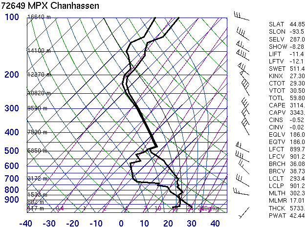
#14 Minneapolis, Minnesota
Excellent: 3343 J/kg CAPE, very little CIN.
Good: 55 knots shear from 0-6 km, but it is unidirectional
Mid-level Lapse Rates:
Decent: from 0 to -15 C, lapse rates are very good but then it goes through a
cloud layer and it can't be discerned above -15 C.
Freezing Level:
14.6 kft
Overall Threat of Severe Hail:
High: CAPE and shear alone in this sounding is enough for a high risk of severe
hail.
Summary of the Event:
Date of Sounding: 20 July 2003 @ 00 UTC
That dry layer in mid-levels indicates a severe wind threat in addition to
the high risk of hail. Storm moved into central and eastern Minnesota by 20
UTC. From 21-0100 UTC MPX logged 27 severe hail reports, with a few baseball
hail reports just west of Minneapolis around 00 UTC.
Good: 2124 J/kg makes it almost excellent, no CIN.
Excellent: 60 knots shear 0-6 km, but unidirectional
Mid-level Lapse Rates:
Excellent: above -10 the lapse rates are nearly dry adiabatic up to -40 C.
Freezing Level:
12.2 kft
Overall Threat of Severe Hail:
High: This is a no brainer. All ingredients are there and very strong in this
sounding
Summary of the Event:
Date of Sounding: 28 April 2002 @ 18 UTC
Locations in Nashville reported golfball hail at 19 UTC. Additional
supercells developed southwest of Nashville, all producing severe hail, and
3.00 inch hail was reported at 20:38 UTC 50 miles southwest of Nashville.
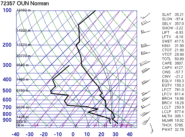
Begin crying: 4127 J/kg, some CIN
Begin crying: ~55 knots shear 0-6 km, 95 knots at 9.5 km, strong veering
profile.
Mid-level Lapse Rates:
Excellent: nearly dry adiabatic in the hail growth zone.
Freezing Level:
15.1 kft
Overall Threat of Severe Hail:
High: Much like the Nashville sounding, the ingredients are outstanding for
severe hail, just about as high as you can get at the same time.
Summary of the Event:
Date of Sounding: 9 May 2003 @ 00 UTC
A supercell moved across the Oklahoma City Metro area around 2130-2300 UTC,
producing an F4 tornado. Although in terms of hail threat, this is just
about as high each parameter listed above gets in the U.S. at the same time.
However, this is essentially a null event in terms of hail. There was a lack
of significant hail from that supercell. It passed directly over a metro
area and there were just 4 hail reports, 2 at 0.75 and 2 at 0.88 inches.
This is an example of storm microphysics playing an important role in hail
production, as underreporting is unlikely in this event.
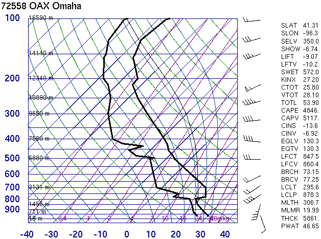
Begin crying: 5117 J/kg CAPE, lots of CIN however. Need a trigger.
Decent: 25 knots shear 0-6 km, but a good veering profile
Mid-level Lapse Rates:
Excellent
Freezing Level:
14.6 kft
Overall Threat of Severe Hail:
High: With the proper trigger, this sounding is a guarantee for severe hail for
any storm that goes up.
Summary of the Event:
Date of Sounding: 3 July 1999 @ 00 UTC
There is CIN on this sounding, but storms broke the cap along a warm front
across Iowa and quickly became supercellular. This event really hammered the
Des Moines CWA, with exceptional numbers of severe hail reports, and the
majority of the reports were golfball and larger. Significant amounts of
severe hail were reported from 16-23 UTC in central Iowa.
Weak: 233 J/kg, no CIN .
Good: 0-3 km shear is strong (40 knots), but 0-6 km shear just 20 knots.
Mid-level Lapse Rates:
Weak: especially around -10 C.
Freezing Level:
9.4 kft
Overall Threat of Severe Hail:
Slight: This is a tough call putting any risk at all. There is some CAPE, pretty
good shear but the shear is shallow. Freezing level very low so marginally
severe hail shouldn't melt too much should it form aloft.
Summary of the Event:
Date of Sounding: 28 June 2001 @ 00 UTC
The upper level vorticity max was quite cold, as freezing levels in late
June were at 9400 feet across Oregon. One report of 0.75 inch hail occured
near Pendleton in eastern Oregon at ~00:00 UTC.
Decent: 489 J/kg, no CIN
Good: 0-5.6 km shear 30 knots, 0-7 km shear 80 knots, nearly unidirectional.
Southwesterly winds of 115 knots at 10 km quite impressive.
Mid-level Lapse Rates:
Decent: but only to -25 C
Freezing Level:
7.6 kft
Overall Threat of Severe Hail:
Slight: Much like the previous case in Oregon, this is a tough call since CAPE
and lapse rates are far from ideal. However, the risk is certainly there with
some CAPE and lapse rates good up to -25 C. That low freezing level should allow
pretty much any size hail that forms aloft to reach the ground.
Summary of the Event:
Date of Sounding: 13 November 2003 @ 00 UTC
Very low freezing level and low EL with a strong upper level vorticity
maximum offshore of southern Califorina. A stationary storm over south
central Los Angeles dumped extraordinary amounts of rainfall and small hail.
None of the hail was "severe", but the amount of the small hail piled up
into 2-3 foot drifts.
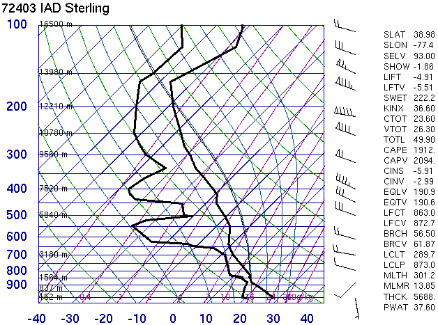
Good: 2094 J/kg, no CIN. Nearly excellent.
Decent: 0-6 km shear 15 knots, but 90 knot westerly jet at the tropopause. Some
veering in the lowest levels.
Mid-level Lapse Rates:
Decent: effectively moist adiabatic
Freezing Level:
12.5 kft
Overall Threat of Severe Hail:
Moderate: The CAPE is great, shear/mid level lapse rates not high enough for a
"high" threat.
Summary of the Event:
Date of Sounding: 2 July 2004 @ 00 UTC
20:50 UTC baseball hail reported in Baltimore County, MD, and at 23 UTC
Washington DC had 0.88 inch hail.
Good: 1215 J/kg, no CIN. Considering low freezing level, CAPE looks good. No
CIN.
Excellent: 0-6 km shear 50 knots, and 115 knots. Unidirectional however.
Mid-level Lapse Rates:
Good: slightly better than moist adiabatic
Freezing Level:
9.4 kft
Overall Threat of Severe Hail:
Moderate: CAPE/shear combinations plenty high for supercells. Lapse rates in
hail growth zones also good. CAPE on the low side but considering the the cool
environment it's significant. This is very close to "High".
Summary of the Event:
Date of Sounding: 22 February 2005 @ 00 UTC
During the afternoon of Feb. 21, north and central Georgia was pounded by a
line of supercells producing very large hail. No tornadoes were reported
from any of the storms. Some statistics and specifics: 60 hail reports, some
up to baseball in size. Metro Atlanta was especially hit hard, between 00:30
and 1:00 UTC, causing millions of dollars in damage.
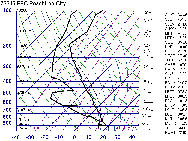
Good: 1951 J/kg, no CIN.
Weak. Although you can find 15 knots max in the 0-6 km layer.
Mid-level Lapse Rates:
Weak, tropical in nature, and hardly any CAPE in the growth zone layer
Freezing Level:
14.7 kft
Overall Threat of Severe Hail:
Slight: CAPE alone should warrant a threat of hail, but in this environment, I
would be surprised to see anything larger than 0.75-1.00 inch.
Summary of the Event:
Date of Sounding: 5 August 2005 @ 00 UTC
Storms fired all along the Atlantic sea breeze across the Miami metro area.
2 hail reports, both 0.75 inch diameter, were recorded:
1945 UTC in Davie, Broward County, and a separate storm, 1945 UTC in Opa
Lacka, Miami-Dade County.
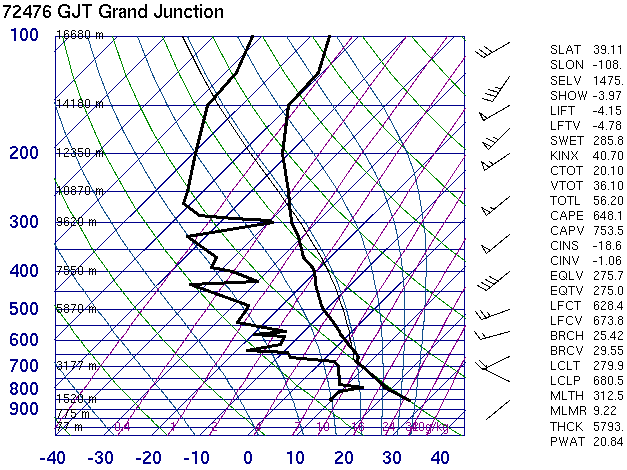
#23 Grand Junction, Colorado
Decent: 753 J/kg, no CIN. You rarely see greater than 1000 J/kg west of the
Rockies outside of Arizona
Decent: 35-40 knots 0-6 km AGL shear, unidirectional
Mid-level Lapse Rates:
Good. Would be excellent but lapse rates are very weak just above -20C
Freezing Level:
14.7 kft
Overall Threat of Severe Hail:
Slight: Close to moderate because of all the parameters being at least decent to
good. Would not be surprised at a few 1.00 inch hail reports.
Summary of the Event:
Date of Sounding: 17 August 2005 @ 00 UTC
Montrose County, Colorado at 20:20 UTC on 16 Aug 2005 1.00 inch hail was
reported in Montrose. Further west into Utah, the storms were more intense.
Flash flooding occurred in Moab. The big story was the large hail in the
Green River, UT area (not much out there, take my word for it). At 23:45 UTC
1.50 inch hail was reported in Castle Dale, and at 00:00 UTC golfball hail
was reported 20 miles southwest of Green River.
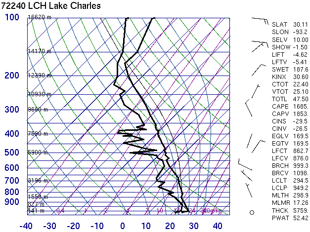
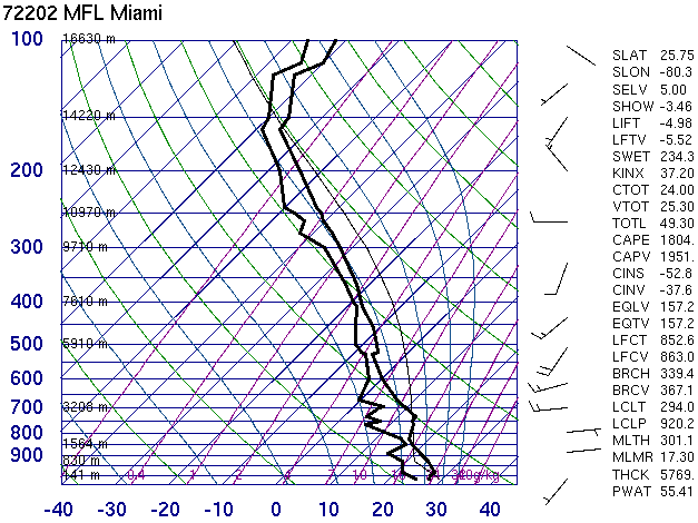
#24 Lake Charles, Louisiana
Good: 1853 J/kg, should be too hard to mix out the shallow nocturnal inversion
Weak: ~10 knots at best from 0-6 km, nothing above that either.
Mid-level Lapse Rates:
Weak: worse than moist adiabatic above -10 C.
Freezing Level:
14.8 kft
Overall Threat of Severe Hail:
None: Even though CAPE is good, the other 2 parameters are exceptionally weak,
such that I doubt any severe hail falls for this event.
Summary of the Event:
Date of Sounding: 4 August 2005 @ 12 UTC
Storms were numerous across southwest Louisiana. There were 3 reports of
severe wind, but no reports of any hail.
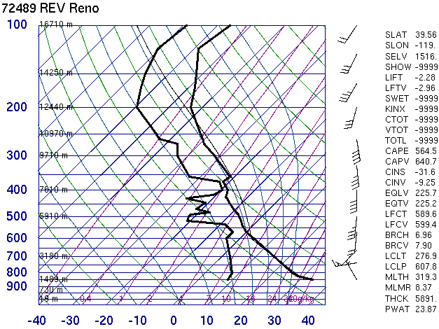
Decent: 640 J/kg, no CIN
Good: ~40 knots from 0-6 km, but in reality the shear is shallow.
Mid-level Lapse Rates:
Decent: Inversion at -20C but all the CAPE is located above the 0C level so
can't complain too much.
Freezing Level:
16.0 kft
Overall Threat of Severe Hail:
Slight: Shear looks good from some rotating cells, no CIN, CAPE sufficient for
some severe hail.
Summary of the Event:
Date of Sounding: 22 July 2005 @ 00 UTC
July 21, 2005 was an active day for severe weather in the Reno area. At 1:30
UTC and 1:36 UTC Sparks, NV in Washoe County had hail reports of 0.75 in and
0.88 inch diameters, respectively. Very strong winds and flash flooding also
plagued Washoe County throughout this time period from the line of
convection.