From there, it seems that a surface low forms over central or western Texas,
and tracks northeastward, into the Mid MS Valley and Lower Ohio Valley.... with
the classic Alabama severe weather track of Arkansas to Kentucky/Illinois. The
surface low will be deepening along the way, from 1004-1006mb to under 996-mb as
it heads toward inland New England areas. This puts the Deep South in the warm
side of the storm.....
Now, beyond a few days, there's really no way whatsoever to know the mesoscale
details of a weather system...and it's the mesoscale details that make or break
a severe thunderstorm/tornado day.... but there are many larger-scale signals
that we look for to know if the overall setup is favorable or unfavorable. Let's
break down those signals with this system and see how we stack up....
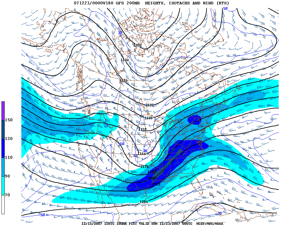
I usually start off by looking at the jet stream, to get an overall feel for the
large scale pattern in the upper-levels, as it has a major major role in how the
other mandatory levels behave. During the winter months, I use the 200-mb level
to find the core of the jet stream, as the colder air is denser, which means the
atmosphere is "thicker", placing the core of the jet stream higher in the
atmosphere. Below is the 12Z GFS 200-mb prog for 180 hrs.
http://img117.imageshack.us/img117/2701/gfs200180mfi7.gif
We see a major upper-level system over the center of the nation with a 130-140
kt jet streak from eastern Texas to southeastern Kentucky. Note that the
northern branch of the jet and the southern branch of the jet are combined here.
This is called phasing, and this adds power to a storm system as you basically
have two branches of the jet stream phasing into one stronger jet. Also note the
diffluence over the Deep South, with wind barbs over Arkansas pointing northeast
to north-northeast and wind barbs over the northern Gulf of Mexico pointing
east-northeast. This evacuation of air in the upper levels in one specific area
promotes rising motion in the atmosphere, and many major severe weather
outbreaks are found in that diffluent area. Note also that Alabama is in the
right-front quadrant of this upper jet. Now, I know that we are taught in
standard meteorology books that rising motion occurs in the left-front and
right-rear quadrants of the upper jet, and sinking motion is found in the
right-front and left-rear quadrants. In the Deep South though, we are much
closer to the Gulf of Mexico, and much further away from the source region of
the capping inversion, than say...Oklahoma. We usually end up with a weaker cap
in a severe weather situation here, than in Oklahoma. That means, that in order
to get discrete, strong updrafts here, when such a dynamic system is present,
there has to be something to counteract all the rising motion on such a weak
cap. The subsidence in the right-front quadrant of the upper jet can often do
this, by "weeding out" the weaker updrafts trying to grow around supercell
thunderstorms. As a matter of fact, all four F5 tornadoes in the state of
Alabama occurred in the right-front quadrant of the upper-level jet...as well as
many other major tornado outbreaks... We all know the days... April 3, 1974; May
27, 1973; April 4, 1977; March 27, 1994; April 8, 1998; November 10, 2002; March
1, 2007.
We move a little lower in the atmosphere, to 500-mb, to get a good picture of
the trough/ridge pattern...get details on shortwaves...areas of positive
vorticity advection and associated rising motion...etc...
http://img117.imageshack.us/img117/962/gfs500180mgh1.gif
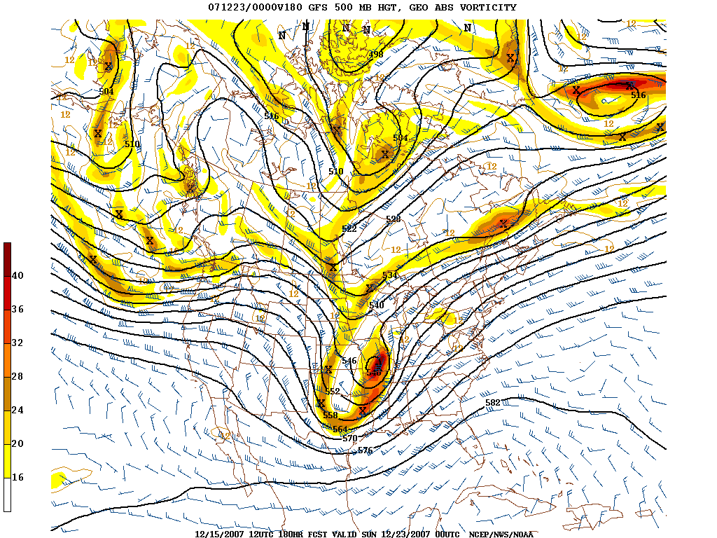
Note again the major system over the center of the nation. The upper-level low
is centered over southern Missouri here, with a 110-kt jet from eastern Texas to
western Tennessee. To put those speeds into perspective, 100-kts is called the
"barb of death" in severe weather forecasting. Also note that the Deep South is
again in the right-front quadrant of the jet, as mentioned above. As with the
upper-levels, we are in the center of strong diffluence, and this will help
promote large scale rising motion in the atmosphere, necessary in aiding
thunderstorm development. Another thing to note is the vorticity pattern here.
Note that we don't have one large vort max, but rather two. This tells me that
the forcing may not be overly strong, so strong that we have all the convection
just instantly forced into a line. The vorticity maximum itself isn't the whole
story though, we look at the advection of that vorticity downstream, to get an
idea of rising motion. Note that the secondary vort max upstream from the Deep
South is parallel to the upper-level winds. The advection pattern associated
with this is known as channel vorticity advection, and is much more subtle. This
also makes me think things may not be instantly forced into a line. Also note
the height pattern. There's an old rule of thumb with synoptic level severe
weather forecasting, that the greatest tornado threat will lie ahead of the
shortwave, between the 564dm and 576dm H5 heights. On the model prog above, that
would be about the northern two-thirds of Alabama.
We move down a little further, to the 700-mb level.
http://img81.imageshack.us/img81/1962/gfs700180mmv3.gif
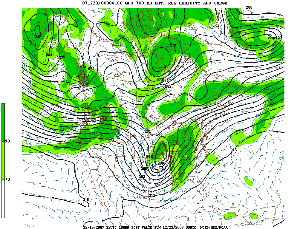
We note the very strong system again centered over Missouri, with a 70-kt jet at
this level punching in from the southwest. Something very important to note is
the very strong dry punch coming across Mississippi and Alabama. Mid-level dry
air will do two things in an environment like this... A) Create subsidence that
will help not only allow breaks in the clouds, but spacing of storms...so that
discrete convection is favored. B) The dry air will allow more evaporational
cooling as moist air is brought upward in developing updrafts, and this
evaporational cooling will make the air surrounding the rising air
colder...meaning that the rising air will continue to rise...and rise faster.
Also note the relative humidity gradient over Mississippi and Alabama. I
typically look for the greatest severe weather threat to be in the gradient from
40% to 80%, and that is much of Mississippi and Alabama on this image.
We move down into the lower-levels of the atmosphere now, by looking at 850-mb.
http://img81.imageshack.us/img81/20/gfs850180mlg6.gif
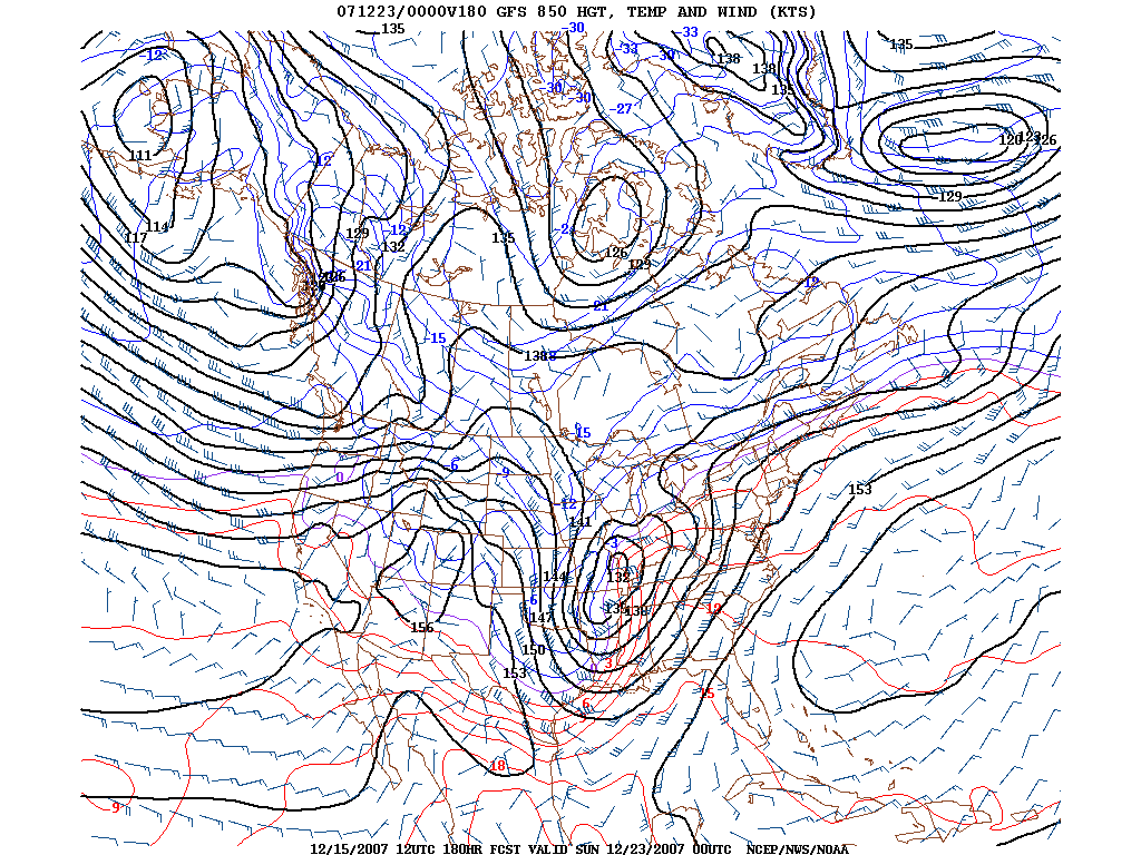
Several things to note here. We have the cyclone at this level centered right
over St. Louis. This puts Alabama deeply within the warm sector of the system.
Note that 12 deg C 850-mb temperatures extend northward to the TN/KY state line.
12 deg C at 850-mb is often a very good indicator for unstable low-level air.
Also note, ahead of the strong cold front over Mississippi, the very strong
south-southwesterly low-level jet of 50-60 kts from southern Louisiana to
central Kentucky, with some of the highest wind speeds over Alabama. This will
mean that not only warm, moist, unstable air races rapidly northward, but there
will be very strong wind fields through the atmosphere, given the winds at the
higher levels as well. This is very favorable for sustained updrafts and updraft
rotation. Note also that the wind barbs originate from the southern Gulf of
Mexico and northwest Caribbean. This is a signal that very rich low-level
moisture will be present in the warm sector of this system. 65 degree dewpoints
look VERY doable to me, along and south of wherever the warm front happens to
setup.
We look at the surface now...
http://img81.imageshack.us/img81/4176/gfsslp180mka3.gif
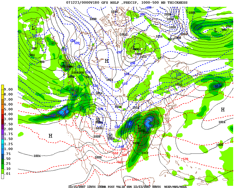
We have a deepening 1000-mb surface low very near Paducah, Kentucky with a
trailing cold front into Mississippi and Louisiana. This is classic surface low
placement for a severe weather outbreak day in Alabama. It appears that the main
warm front is over the Ohio Valley, with a secondary warm front over north
central Alabama. This secondary warm front will be the northern edge of the most
unstable air....and this boundary will also be an area of enhanced low-level
shear. Note 1000-500mb thickness of 564dm well into Alabama at this time.
1000-500mb thickness of 564dm is often a signal for significantly unstable air
in the cool season. No, you won't see 3000 SBCAPE, but you probably never will
in Alabama. This is the signal for air sufficiently unstable for significant
severe weather, IF all other parameters are favorable. Also note that 1008-mb
surface pressures extend well into South Alabama. I typically look for surface
pressures at or below 1008-mb for a significant tornado threat. One of the "old
school" rules of thumb. Also note the isobars... To get the surface wind
direction, draw a wind barb 30 degrees inward from an isobar for low pressure,
as winds converge inward toward a low pressure area. That makes the surface
winds over Alabama out of the southeast. Now, compare that to the wind
directions and speeds in the other progs through the different layers, and you
have a strongly veering wind profile with height. This kind of veering wind with
height is very favorable for rotating thunderstorms.
That's all what we can see right now..... but as stated above, it's the
mesoscale details that make or break an event, and we've all seen that before
too. What if the unstable air doesn't make it far enough northward? What if
convection forms on the coast to block inflow from further northward? Where does
that secondary warm front setup? What will the track of the surface low be?
What's the timing of the system? Those are all VERY important questions, that
can't be answered right now. All we can see is the larger scale indicators, and
they seem to be becoming consistent on an idea that favors a POTENTIAL severe
weather event before Christmas. There's still plenty of time for this all to
change, but it needs to be monitored closely in the coming days.